
The Cairngorms are a mountain range in the eastern Highlands of Scotland closely associated with the mountain of the Cairn Gorm. The Cairngorms became part of Scotland's second national park on 1 September 2003. Although the Cairngorms give their name to, and are at the heart of, the Cairngorms National Park, they only form one part of the national park, alongside other hill ranges such as the Angus Glens and the Monadhliath, and lower areas like Strathspey.

A mountain hut is a building located high in the mountains, generally accessible only by foot, intended to provide food and shelter to mountaineers, climbers and hikers. Mountain huts are usually operated by an Alpine Club or some organization dedicated to hiking or mountain recreation. They are known by many names, including alpine hut, mountain shelter, mountain refuge, mountain lodge, and mountain hostel.

A bothy is a basic shelter, usually left unlocked and available for anyone to use free of charge. It was also a term for basic accommodation, usually for gardeners or other workers on an estate. Bothies are found in remote mountainous areas of Scotland, Northern England, Northern Ireland, Wales and the Isle of Man. They are particularly common in the Scottish Highlands, but related buildings can be found around the world. A bothy was also a semi-legal drinking den in the Isle of Lewis. These, such as Bothan Eòrapaidh, were used until recent years as gathering points for local men and were often situated in an old hut or caravan.

A hut is a primitive dwelling, which may be constructed of various local materials. Huts are a type of vernacular architecture because they are built of readily available materials such as wood, snow, ice, stone, grass, palm leaves, branches, hides, fabric, or mud using techniques passed down through the generations.

Sandwood Bay is a natural bay in Sutherland, on the far north-west coast of mainland Scotland. It is best known for its remote 1-mile-long (1.6 km) beach and Am Buachaille, a sea stack, and lies about 5 miles south of Cape Wrath. Behind the bay's large dunes, stretches the freshwater Sandwood Loch.

Glen Affric is a glen south-west of the village of Cannich in the Highland region of Scotland, some 15 miles (24 km) to the west of Loch Ness. The River Affric runs along its length, passing through Loch Affric and Loch Beinn a' Mheadhoin. A minor public road reaches as far as the end of Loch Beinn a' Mheadhoin, but beyond that point only rough tracks and footpaths continue along the glen.

A wilderness hut, bothy, backcountry hut, or backcountry shelter is a free, primitive mountain hut for temporary accommodation, usually located in wilderness areas, national parks and along backpacking and hiking routes. They are found in many parts of the world, such as Finland, Sweden, Norway, northern Russia, the Alps, the Pyrenees. Scotland, Australia, New Zealand, Canada, and the United States. Huts are basic and unmanned, without running water.
The Mountain Bothies Association (MBA) is a Scottish registered charity. It looks after 104 bothies and two emergency mountain shelters. Of these, only two bothies are owned by the charity. The remainder are maintained with the agreement and encouragement of the owners. The majority are in Scotland with the remainder in Wales and Northern England. These may be stayed in without charge.

Corrour Bothy is a simple stone building on Mar Lodge Estate, Aberdeenshire, Scotland.
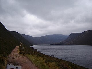
Loch Muick is an upland, freshwater loch lying approximately 5 mi (8.0 km) south of Braemar, Scotland at the head of Glen Muick and within the boundary of the Balmoral estate.

A shieling, also spelt sheiling, shealing and sheeling, is a hut, or collection of huts, once common in wild or lonely places in the hills and mountains of Scotland and northern England. The word is also used for a mountain pasture for the grazing of cattle in summer, implying transhumance between there and a valley settlement in winter.
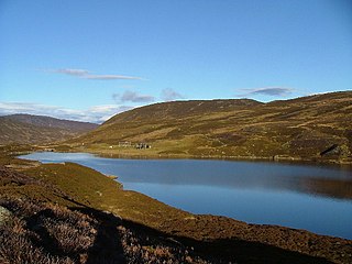
Loch Callater is an upland, freshwater loch lying approximately 5 miles (8 km) south of Braemar, Scotland. The loch trends in a northwest to southeast direction and is surrounded on both sides by steep hills. It is approximately 1.6 km (1 mi) in length.
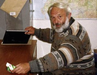
Irvine Butterfield (1936–2009) was an environmentalist, hillwalker and author of several books about mountains and the outdoor environment who took a significant role in the running of organisations with such interests in Scotland. He was a good organiser and volunteered large amounts of his time to causes he believed in.

Lurg Mhòr is a remote 986-metre (3,235 ft) mountain, a Munro, in the Northwest Highlands of Scotland at the high point of an east–west range of hills comprising Meall Mor, Lurg Mhòr and Bidein a' Choire Sheasgaich.
Bidein a' Choire Sheasgaich is a remote 945-metre (3,100 ft) mountain, a Munro, in the Northwest Highlands of Scotland at the western end of an east–west range of hills comprising a Munro Top Meall Mor, the Munro at the highest point of the ridge Lurg Mhòr, and Bidein a' Choire Sheasgaich itself.

Gorton railway station or Gortan railway station, named for the nearby Meall a Ghortain area of high ground, was a remote rural private railway station on Rannoch Moor, Argyll and Bute, Scotland. Opened in 1894 by the North British Railway, it was located at the present day Gorton Crossing engineer's siding where the ancient Rannoch Drove Road crossed the railway line.
Loch Skiach is a small freshwater loch in Perth and Kinross, Scotland, situated 4 miles southwest of Ballinluig.

Loch Moraig is a freshwater loch, located 2 miles northeast of Blair Atholl. Loch Moraig was an artificial loch, originally a Snipe marsh, that was dammed in the south, to create the current loch.
Aonach Beag is a 1,116-metre (3,661 ft) mountain in the Highlands of Scotland in the remote area between Loch Ericht and Loch Laggan located about 4 kilometres (2.5 mi) northwest of Ben Alder. Its prominence is 99 metres (325 ft) with its parent peak, Geal-Charn, about 1 kilometre (0.62 mi) to the east. In Gaelic, Aonach Beag means "little ridge" despite it being a Munro. It should not be confused with the better-known Munro near Ben Nevis, also called Aonach Beag, about 30 kilometres (19 mi) to the west.

