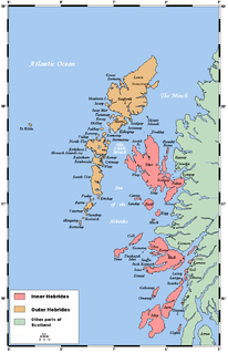
The Hebrides are a Scottish archipelago off the west coast of the Scottish mainland. The islands fall into two main groups, based on their proximity to the mainland: the Inner and Outer Hebrides.

The Outer Hebrides or Western Isles, sometimes known as Na h-Innse Gall or the Long Isle/Long Island, is an island chain off the west coast of mainland Scotland. The islands are geographically coextensive with Comhairle nan Eilean Siar, one of the 32 unitary council areas of Scotland. They form part of the archipelago of the Hebrides, separated from the Scottish mainland and from the Inner Hebrides by the waters of the Minch, the Little Minch, and the Sea of the Hebrides. Scottish Gaelic is the predominant spoken language, although in a few areas English speakers form a majority.

Harris is the southern and more mountainous part of Lewis and Harris, the largest island in the Outer Hebrides, Scotland. Although not an island itself, Harris is often referred to as the Isle of Harris, which is the former postal county and the current post town for Royal Mail postcodes starting HS3 or HS5.

North Uist is an island and community in the Outer Hebrides of Scotland.

South Uist is the second-largest island of the Outer Hebrides in Scotland. At the 2011 census, it had a usually resident population of 1,754: a decrease of 64 since 2001. The island, in common with the rest of the Hebrides, is one of the last remaining strongholds of the Gaelic language in Scotland. South Uist's inhabitants are known in Gaelic as Deasaich (Southerners). The population is about 90% Roman Catholic.

Benbecula is an island of the Outer Hebrides in the Atlantic Ocean off the west coast of Scotland. In the 2011 census, it had a resident population of 1,283 with a sizable percentage of Roman Catholics. It is in a zone administered by Comhairle nan Eilean Siar or the Western Isles Council. The island is about 12 kilometres from west to east and a similar distance from north to south. It lies between the islands of North Uist and South Uist and is connected to both by road causeways. Benbecula's main settlement and administrative centre is Balivanich.

"Uist" is a group of six islands and are part of the Outer Hebridean Archipelago, part of the Outer Hebrides of Scotland.
Berneray is an island and community in the Sound of Harris, Scotland. It is one of fifteen inhabited islands in the Outer Hebrides. It is famed for its rich and colourful history which has attracted much tourism. It lies within the South Lewis, Harris and North Uist National Scenic Area, one of 40 such areas in Scotland which are defined so as to identify areas of exceptional scenery and to ensure its protection from inappropriate development.
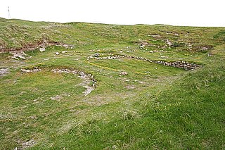
Cladh Hallan is an archaeological site on the island of South Uist in the Outer Hebrides in Scotland. It is significant as the only place in Great Britain where prehistoric mummies have been found. Excavations were carried out there between 1988 and 2002, indicating the site was occupied from 2000 BC.

Howmore lies on the island of South Uist to the southwest of Loch Druidibeg. The mountain of Haarsal rises to 139 m (456 ft) to the east and immediately south is the smaller settlement of Howbeg. Howmore is also within the parish of South Uist.

Askernish is a crofting community on South Uist, in the Outer Hebrides, Scotland. Askernish is in the parish of South Uist, and is situated on the A865 north of Daliburgh. The Askerish golf course, designed by Old Tom Morris is located on the coast and has a view of the beach.
Ceann Ear is the largest island in the Monach or Heisgeir group off North Uist in north west Scotland. It is 203 hectares in size and connected by sandbanks to Ceann Iar via Sibhinis at low tide. It is said that it was at one time possible to walk all the way to Baleshare, and on to North Uist, 5 miles away at low tide. In the 16th century, a large tidal wave was said to have washed this away.
Ospadal Uibhist agus Bharraigh is a community hospital in Benbecula which provides services on the islands of North Uist, South Uist and Benbecula in the Western Isles of Scotland. It is managed by NHS Western Isles.

Scolpaig Tower is a Georgian folly located near the village of Scolpaig on the island of North Uist in the Outer Hebrides. The name probably derives from the Old Norse scolpvik, or 'Scolp Bay'.
The flora and fauna of the Outer Hebrides in north west Scotland comprises a unique and diverse ecosystem. A long archipelago, set on the eastern shores of the Atlantic Ocean, it attracts a wide variety of seabirds, and thanks to the Gulf Stream a climate more mild than might be expected at this latitude. Because it is on the Gulf Stream, it also occasionally gets exotic visitors.
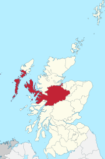
Inverness-shire is a historic county, registration county and lieutenancy area of Scotland. Covering much of the Highlands and Outer Hebrides, it is Scotland's largest county, though one of the smallest in population, with 67,733 people or 1.34% of the Scottish population.

South Lewis, Harris and North Uist is a large national scenic area (NSA) in the Western Isles of Scotland. It is one of 40 such areas in Scotland, which are defined so as to identify areas of exceptional scenery and to ensure its protection from inappropriate development. The designated area covers 202,388 ha in total, of which 112,301 ha is on land, with a further 90,087 ha being marine, making it the largest of the NSAs in both total and marine area. The designated area includes the mountainous south west of Lewis, all of Harris, the Sound of Harris and the northern part of North Uist.

Loch Druidibeag is a freshwater loch situated on the island of South Uist, in the Outer Hebrides of Scotland. The loch is near the northern end of the island, to the north-east of Howmore and to the east of the A865 road and south of the B890.
