
Milngavie is a town in East Dunbartonshire, Scotland and a suburb of Glasgow. It is on the Allander Water, at the northwestern edge of Greater Glasgow, and about 10 kilometres (6.2 mi) from Glasgow city centre. It neighbours Bearsden. Milngavie is a commuter town, with much of its working population travelling to Glasgow to work or study. The town is served by Milngavie railway station on the North Clyde Line of the SPT rail network, which links it to Central Glasgow.
The Vale of Leven is an area of West Dunbartonshire, Scotland, in the valley of the River Leven. Historically, it was part of The Lennox, the name of which derives from the Gaelic term Leamhnach, meaning field of the Leven. Leamnha is thought to mean elm-water.

Dunbartonshire or the County of Dumbarton is a historic county, lieutenancy area and registration county in the west central Lowlands of Scotland lying to the north of the River Clyde. Dunbartonshire borders Perthshire to the north, Stirlingshire to the east, Lanarkshire and Renfrewshire to the south, and Argyllshire to the west. The boundaries with Lanarkshire and Stirlingshire are split in two owing to the existence of an exclave around Cumbernauld.

Bearsden is a town in East Dunbartonshire, Scotland, on the northwestern fringe of Greater Glasgow. Approximately 6 miles (10 km) from Glasgow City Centre, the town is effectively a suburb, and its housing development coincided with the 1863 introduction of a railway line. The town was named after Bearsden railway station, which was named after a nearby cottage.

Bearsden and Milngavie was formerly (1975–96) one of nineteen local government districts in the Strathclyde region of Scotland, north of the City of Glasgow.

Back is a district and a village on the east coast of the Isle of Lewis in the Outer Hebrides, Scotland, situated on a coastal area known as Loch a'Tuath, or Broad Bay. Back is within the parish of Stornoway, and is situated on the B895. The village/district utilises the motto "Tre Dhilseachd Buaidh" as seen on the crest of Back FC.
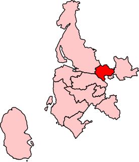
Clydebank and Milngavie is a constituency of the Scottish Parliament covering part of the council areas of East Dunbartonshire and West Dunbartonshire. It elects one Member of the Scottish Parliament (MSP) by the first past the post method of election.It is also one of ten constituencies in the West Scotland electoral region, which elects seven additional members, in addition to the ten constituency MSPs, to produce a form of proportional representation for the region as a whole.
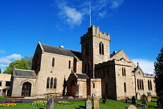
New Kilpatrick, is an ecclesiastical Parish and former Civil Parish in Dunbartonshire. It was formed in 1649 from the eastern half of the parish of Kilpatrick, the western half forming Old Kilpatrick. New Kilpatrick is also a disused name for the town of Bearsden.

Bearsden railway station serves Bearsden, East Dunbartonshire near Glasgow, Scotland. The railway station is managed by ScotRail and lies on the Argyle Line and North Clyde Lines.
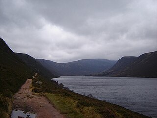
Loch Muick is an upland, freshwater loch lying approximately 5 mi (8.0 km) south of Braemar, Scotland at the head of Glen Muick and within the boundary of the Balmoral estate.
Clydebank was a local government district in the Strathclyde region of Scotland from 1975 to 1996, lying immediately to the north-west of the regional capital Glasgow.

The Kilpatrick Hills are a range of hills in central Scotland, stretching from Dumbarton in the west to Strathblane in the east. Strathblane divides the Kilpatricks from the Campsie Fells to the east, while to the north is part of the Loch Lomond and the Trossachs National Park. To west and south the hills are fringed by the settlements of Balloch, Dumbarton, Milton, Bowling, Old Kilpatrick, Clydebank, Bearsden and Milngavie. The majority of the range is within West Dunbartonshire, although it extends into the East Dunbartonshire and Stirling areas.

Netherton is a district of Glasgow, in the north of the city, bounded by Temple to the south, Knightswood to the west while Westerton in Bearsden lies to the North and East. Netherton appears in Joan Blaeu's 1662 Atlas of Scotland and many subsequent old maps. It is currently not shown on Ordnance Survey maps greater than 1:25000 scale.
The Bearsden Choir is a choir of 140 mixed adult voices based in Bearsden, Scotland. It was formed in 1968 and performs both sacred and secular classical choral works. The singer Jamie MacDougall is its Honorary President.

Hillend Loch is an artificial lake, called a loch in Scots English, located to the east of Caldercruix in North Lanarkshire, Scotland. It is bordered on its south shore by the A89 road.

Loch Tarsan; is a freshwater loch and impounding reservoir located 13 kilometres Northwest of Dunoon, on the Cowal peninsula in Argyll and Bute, Scotland. This three-armed Reservoir extends into both Glen Tarsan and Glen Lean. It supplies water to the Striven Hydro-Electric Scheme. The larger of the two dams is 17.6 metres high and was completed in 1953. The water that is collected in the loch, are piped to the hydro-electric generating station, located at Ardtaraig, at the head of Loch Striven.

Loch Loskin is a freshwater loch in Ardnadam, Argyll and Bute, Scotland. The outflow from the loch is the Milton Burn, which winds its way through Dunoon to the Firth of Clyde. The A885 from Sandbank known as the "High Road" locally passes the loch.
Loch Lomond Rowing Club is a rowing club on the River Leven, based at Heather Avenue, Balloch, Alexandria, West Dunbartonshire. The club is affiliated to Scottish Rowing.

