Kinlochbervie is a scattered harbour village in the north west of Sutherland, in the Highland region of Scotland. It is the most northerly port on the west coast of Scotland.

Inverpolly is the name given to a large area of northern Wester Ross in the Northwest Highlands of Scotland, north of Ullapool. The area contains several prominent hills, rising up from a rough landscape of bogs and lochans. From 1961, the area was designated national nature reserve but since 2004, the designation has been limited to the area of Knockan Crag. The area supports a large number of high-quality freshwater loch habitats, the majority of which are oligotrophic. Major peaks in the area include Stac Pollaidh, Cul Mòr, Cul Beag. At the heart of Inverpolly lies the large irregular shaped Loch Sionascaig.
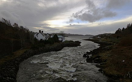
Lochinver is a village at the head of the sea loch Loch Inver, on the coast in the Assynt district of Sutherland, Highland, Scotland. A few miles north-east is Loch Assynt which is the source of the River Inver which flows into Loch Inver at the village. There are 200 or so lochans in the area, popular with anglers. Lochinver is dominated by the "sugar loaf" shape of Caisteal Liath, the summit peak of nearby Suilven.

Habost is the name of two crofting townships on the Isle of Lewis in the Outer Hebrides of Scotland.
Loch Long is a sea loch situated on the western coast of Scotland, in the Highlands. It is a popular destination for tourists and fishers.
Bernisdale is a small township, near the head of Loch Snizort Beag, Isle of Skye in the Highlands and Islands and is in the Scottish council area of Highland.

Luib is a crofting and fishing settlement on the south east shore of the sea loch, Loch Ainort near Broadford, on the island of Skye in Scotland. It is in the council area of Highland.The settlement of Dunan is 1 mile directly east of Luib, along the A87 coast road.

Mellon Charles is a remote crofting village on the north east shore of Loch Ewe near Gairloch in Wester Ross, in the Highland council area of Scotland.
Kensaleyre is a scattered crofting township, part of a group of settlements clustered around the A87 road on the shore of Loch Snizort Beag on the Trotternish peninsula of the island of Skye in the Highlands and Islands of Scotland. It is in the council area of Highland.

Bualintur is a remote township, which lies at the head of Loch Brittle on the island of Skye in the Highlands of Scotland and is in the Scottish council area of Highland. Accessed only by the Glen Brittle bridge (footbridge) that appears in the Royal Commission on Ancient and Historical Monuments in Scotland Bualintur affords some of the best views of the Cuillin hills, and is the point of access for several of Skye' s most dramatic coastal and forest walks. In recent history it was the central township of Glen Brittle, with the post office and school for the community. It was once a thriving community before the effects of the highland clearances and depopulation of the highlands and islands took place, and many ruined houses can be seen among the existing houses.
Mybster is a small village, in Caithness, Scottish Highlands, and is in the Scottish council area of Highland.

Inverkirkaig is extremely remote scattered crofting township, situated on the north eastern bay, of the sea loch Loch Kirkaig, in the Assynt district of Sutherland, Scottish Highlands and is in the Scottish council area of Highland.

Diabaig is a remote coastal fishing and crofting township in Wester Ross, in the Northwest Highlands of Scotland. Diabaig lies on the north shore of the sea loch of Loch Diabaig, an inlet off the north side of Loch Torridon, and is in the Highland council area.

Badnaban is a remote scattered coastal village, which lies on the south shore of the sea loch, Loch Inver, in the Assynt district of the west coast of Sutherland, Scottish Highlands. and is in the Scottish council area of Highland.
Strathan is a remote scattered coastal village, located in Bàgh an t-strathain Bay, which lies on the south shore of the sea loch, Loch Inver, in the Assynt district of the west coast of Sutherland, Scottish Highlands and is in the Scottish council area of Highland. Strathan is situated less than 1 mile northeast of Badnaban, 1 mile north of Inverkirkaig, and 2 miles southwest of Lochinver

Sinclairs Bay is a bay on the eastern coast of Caithness, in the Scottish Highlands.

Loch Awe is a small loch, located 4 miles south of Loch Assynt and next to the village of Ledmore, within the Assynt area of Sutherland, Scotland. The loch is located in an area along with neighbouring Coigach, as the Assynt-Coigach National Scenic Area, one of 40 such areas in Scotland.

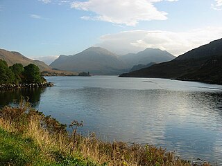
Loch Sionascaig is a large irregular shaped, freshwater loch in the remote Coigach area of northern Wester Ross. It is located 5.5 miles southeast of the village of Lochinver and is situated within the Inverpolly Forest.

Loch Osgaig is a small remote and deep freshwater loch, orientated on north-west to south-east axis, that is located 1 miles south of Enard Bay and 2 mile northeast of Achiltibuie and immediately north west of Loch Bad a' Ghaill. It is located in the Coigach peninsula in Lochbroom, Wester Ross.