
The River Ness is a river in Highland, Scotland, UK. It flows from Loch Dochfour, at the northern end of Loch Ness, north-east to the mouth of the Beauly Firth at Inverness, a distance of about 6 miles, with a fall in height of about 16 metres. The river is the origin of the name of Inverness, which is from Scottish Gaelic: Inbhir Nis, meaning "Mouth of the Ness".

Gairloch is a village, civil parish and community on the shores of Loch Gairloch in Wester Ross, in the North-West Highlands of Scotland. A tourist destination in the summer months, Gairloch has a golf course, a museum, several hotels, a variety of shops, takeaway restaurants, a community centre, a leisure centre with sports facilities, a local radio station, beaches and nearby mountains. Gairloch is one of the principal villages on the North Coast 500 route.
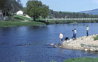
The River Spey is a river in the northeast of Scotland. At 98 mi (158 km) it is the ninth longest river in the United Kingdom, as well as the second longest and fastest-flowing river in Scotland.. It is important for salmon fishing and whisky production.

Strathnaver or Strath Naver is the fertile strath of the River Naver, a famous salmon river that flows from Loch Naver to the north coast of Scotland. The term has a broader use as the name of an ancient province also known as the Mackay Country, once controlled by the Clan Mackay and extending over most of northwest Sutherland.

The River Shin is a river in the Scottish North West Highlands.

Strathmore is a strath or wide valley in Sutherland in northern Scotland. The strath is in the parish of Durness to the south-east of Loch Eriboll. It runs north–south and has a minor road running alongside the Strathmore River which flows along the valley floor northwards into Loch Hope. Ben Hope is to the east.

Borgie is a hamlet in Sutherland, Highland, Scotland. Historically it was part of the 12,600-acre (5,100-hectare) Tongue estate with shooting rights, and it contains the Borgie Lodge, now a bed and breakfast. Borgie is noted for its salmon, which are caught in the nearby River Borgie.
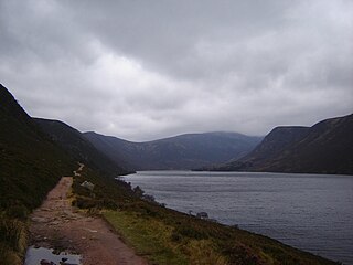
Loch Muick is an upland, freshwater loch lying approximately five miles south of Braemar, Scotland at the head of Glen Muick and within the boundary of the Balmoral estate.

The River Garry in Inverness-shire is a Scottish river punctuated by two long Lochs, in the region of Lochaber. It flows broadly west to east through Glen Garry, starting in a wilderness to the east of Knoydart and ending at Loch Oich in the Great Glen, which forms part of the Caledonian Canal. There are a few tiny settlements within Glen Garry, but the only village of any size near to the river is Invergarry, at its mouth. Loch Quoich at the western end of the watercourse is dammed by the largest mass earth fill dam in Scotland, and supplies water to Quoich hydroelectric power station. Loch Garry is dammed by a much smaller dam in the gorge where the river begins its descent to Invergarry, and supplies water to Invergarry hydroelectric power station, close to the mouth of the river. Both hydroelectric schemes were built in the 1950s, with the aim of stimulating economic regeneration in the area. They have altered the ecology of the river, as both lochs were made considerably bigger as a result of constructing the dams.

Altnaharra is a small hamlet in Sutherland in the Highland region of northern Scotland. The hamlet is on the A836 road, close to its junction with the B873. The nearest villages are Lairg and Tongue. Lochs in the area include Loch Naver and Loch Eriboll.
Badcall comprises two remote hamlets, called Lower Badcall and Upper Badcall. Upper Badcall, a crofting township, is the larger of the two and is situated on the western shore of Badcall Bay. Lower Badcall is located less than 1 mile to the east on the eastern shore of Badcall Bay. Badcall is on the west coast of Sutherland, Scottish Highlands and is in the Scottish council area of Highland.
Loch Dionard is a medium-sized loch in the Durness Parish, in Sutherland, Highland Council Area, Northern Scotland. It is in the North-Western Highlands about four miles south of Polla.

Loch Borralan is a freshwater loch in the Assynt District of Sutherland in the Highland Council Area, northern Scotland.

Loch Badanloch is a loch in Sutherland in the Highland Council Area of northern Scotland.
Loch Nan Clar is a loch in Sutherland in the Highland Council Area of northern Scotland. It is located near the B871 main road, and there is no settlement directly on the lake although the hamlets of Gearnsary and Garvault are very nearby. The loch is used as both a reservoir and as one of few salmon fishery areas in Highland.
Loch Rimsdale is a loch in the Farr parish in Sutherland in the Highland Council Area of northern Scotland. It is located near the B871 main road. There are no settlements directly on the loch however the hamlet of Gearnsary and the Farmstead of Rimsdale are very nearby. The loch is used as both a reservoir and as one of few salmon fishery areas in Highland.

Loch Hope is a loch in the Durness parish in Sutherland in the Highland Council Area of northern Scotland. It is located on the A838 main road. The settlements of Hope, Lochside, and Muiseal directly on the loch in addition nearby there's Inverhope, Heilam, Moine House, Alltnacaillich, Strathmore, etc.. The Loch is a large tourist destination for the area around it.

Loch Brora is a loch in the Golspie parish near the east coast of Sutherland in the Highland council area in Northern Scotland. It is located directly south of a small road which links a few miles east with the A9 in Brora from where the loch gets its name.

Loch Choire is a loch in Sutherland in the Highland council area of northern Scotland. It is located at the end of a rural street which links the loch and the lodges around it with Badanloch Lodge and the B871 main road.

