
The West Highland Way is a linear long-distance route in Scotland. It is 154 km long, running from Milngavie north of Glasgow to Fort William in the Scottish Highlands, with an element of hill walking in the route. The trail, which opened in 1980, was Scotland's first officially designated Long Distance Route, and is now designated by NatureScot as one of Scotland's Great Trails. It is primarily intended as a long distance walking route, and whilst many sections are suitable for mountain biking and horseriding there are obstacles and surfaces that will require these users to dismount in places.
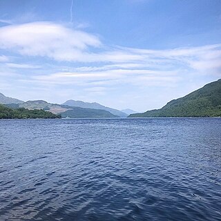
Loch Lomond is a freshwater Scottish loch which crosses the Highland Boundary Fault, often considered the boundary between the lowlands of Central Scotland and the Highlands. Traditionally forming part of the boundary between the counties of Stirlingshire and Dunbartonshire, Loch Lomond is split between the council areas of Stirling, Argyll and Bute and West Dunbartonshire. Its southern shores are about 23 kilometres (14 mi) northwest of the centre of Glasgow, Scotland's largest city. The Loch forms part of the Loch Lomond and The Trossachs National Park which was established in 2002.
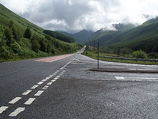
The A82 is a major road in Scotland that runs from Glasgow to Inverness via Fort William. It is one of the principal north-south routes in Scotland and is mostly a trunk road managed by Transport Scotland, who view it as an important link from the Central Belt to the Scottish Highlands and beyond. The road passes close to numerous landmarks, including Loch Lomond, Rannoch Moor, Glen Coe, the Ballachulish Bridge, Ben Nevis, the Commando Memorial, Loch Ness, and Urquhart Castle. Along with the A9 and the A90 it is one of the three major north–south trunk roads connecting the Central Belt to the North.
Sutherland is a historic county, registration county and lieutenancy area in the Highlands of Scotland. The name dates from the Viking era when the area was ruled by the Jarl of Orkney; although Sutherland includes some of the northernmost land on the island of Great Britain, it was called Suðrland from the standpoint of Orkney and Caithness.
Loch Morar is a freshwater loch in the Rough Bounds of Lochaber, Highland, Scotland. It is the fifth-largest loch by surface area in Scotland, at 26.7 km2 (10.3 sq mi), and the deepest freshwater body in the British Isles with a maximum depth of 310 m (1,017 ft). The loch was created by glacial action around 10,000 years ago, and has a surface elevation of 9 metres (30 ft) above sea level. It separates the traditional district of North Morar, from Arisaig and Moidart.

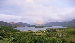
Loch Shiel is a freshwater loch situated 20 kilometres (12 mi) west of Fort William in the Highland council area of Scotland. At 28 kilometres long it is the 4th longest loch in Scotland, and is the longest to have retained a natural outflow without any regulation of its water level, being 120 m (393 ft) deep. Its nature changes considerably along its length, being deep and enclosed by mountains in the north east and shallow surrounded by bog and rough pasture in the south west, from which end the 4 km River Shiel drains to the sea in Loch Moidart near Castle Tioram.
The geography of Scotland is varied from rural lowlands to unspoilt uplands, and from large cities to sparsely inhabited islands. Located in Northern Europe, Scotland comprises the northern part of the island of Great Britain as well as 790 surrounding islands encompassing the major archipelagos of the Shetland Islands, Orkney Islands and the Inner and Outer Hebrides. The only land border is with England, which runs for 96 miles in a northeasterly direction from the Solway Firth in the west to the North Sea on the east coast. Separated by the North Channel, the island of Ireland lies 13 nautical miles from Mull of Kintyre on the Scottish mainland. Norway is located 190 nmi (350 km) northeast of Scotland across the North Sea. The Atlantic Ocean, which fringes the coastline of western and northern Scotland and its islands, influences the temperate, maritime climate of the country.

The Brack is a mountain, located in the Arrochar Alps, on the south side of Glen Croe, near Loch Goil in Argyll and Bute in Scotland. The Brack has two summits: the lower peak, Cruach Fhiarach, can be seen from the shores of Loch Long, and the main peak is seen from Glen Croe and Loch Goil.

Sgorr Ruadh is a mountain between Strath Carron and Glen Torridon in Wester Ross in the Northwest Highlands of Scotland. It is located in Coire Lair near Achnashellach along with two other mountains, Beinn Liath Mhòr and Fuar Tholl, and is often climbed together with one or both of these other mountains.
The A815 is a major road located on the Cowal peninsula, in Argyll and Bute, Scotland. It runs for about 35.7 miles (57.5 km) from the A83, near Cairndow, in the north, to Toward in the south. It passes beside three lochs, while its final stretch is along the Firth of Clyde.

Càrn Gorm is a mountain in the Breadalbane region of the Scottish Highlands, with a height of 1,029 metres (3,376 ft). It stands in a group of four Munro mountains known as the Càrn Mairg group or the Glen Lyon Horseshoe, on the north side of Glen Lyon, Perthshire.

Sgùrr Ghiubhsachain is a mountain in the Lochaber area in the west of Scotland. Its summit is the highest point in a group of mountains that stand south of Glenfinnan, to the south east of the northern part of Loch Shiel. It is considerably lower than the nearby Nevis range, but it is a long way from a public road. Its slopes are steep and rugged on all sides and are devoid of paths. Despite easy access to the trail head from the road from Fort William to Mallaig, an individual or party that climbs this mountain may be alone there, even on a fine day in the summer.

Loch Veyatie is a large freshwater loch in north-west Scotland. It stretches for 6 km north-westwards from the settlement of Elphin, and lies between Suilven and Cùl Mòr. The loch is located in an area known as the Assynt-Coigach National Scenic Area, one of 40 such areas in Scotland.

Loch a' Bhraoin, Loch Broom, is a freshwater loch, located in Wester Ross, in Ross-shire, on the west coast of Scotland.
Loch Freuchie, also known as Fraoch, the heatherly loch, is a large freshwater loch on a north-west to south-east orientation, within Glen Quaich in Perth and Kinross. The loch is located 2 miles (3.2 km) west of Amulree and 6.5 miles (10.5 km) southeast of Kenmore.

Loch a' Mhadail or Loch a' Mhiotailt is a small freshwater lochan that lies immediately to the south-west of Loch Veyatie and is connected by a channel to Loch Veyatie within the area of Inverpolly. The channel measures about 20 foot in length, 10 feet in width and 1 foot in depth. When the water level is low, Loch a' Mhadail is separated from Loch Veyatie by a dyke made of Gneiss.

Loch Sionascaig is a large irregular shaped, freshwater loch in the remote Coigach area of northern Wester Ross. It is located 5.5 miles southeast of the village of Lochinver and is situated within the Inverpolly Forest.

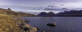
Loch Lurgainn is a large remote and deep freshwater loch with a crescent shape with its concave side turned to the south. It is located in the Coigach peninsula in Lochbroom, Wester Ross. Loch Lurgainn is located 8 miles north of Ullapool and two miles south of Loch Sionascaig and is 3.5 miles southeast of Enard Bay. The scenic qualities of Coigach, along with neighbouring Assynt, have led to the area being designated as the Assynt-Coigach National Scenic Area, one of 40 such areas in Scotland. The main settlement in the area, located directly to the north-west is Achiltibuie.
Loch Bad a' Ghaill is a small remote and deep freshwater loch that is located 10 miles north of Ullapool and immediately north west of Loch Lurgainn. It is located in the Coigach peninsula in Lochbroom, Wester Ross. The scenic qualities of Coigach, along with neighbouring Assynt, have led to the area being designated as the Assynt-Coigach National Scenic Area, one of 40 such areas in Scotland. The main settlement in the area, located directly to the north-west is Achiltibuie.

Lochan Fada is a large remote and deep freshwater loch that is located three miles north-east of Loch Maree in Wester Ross in the Northwest Highlands of Scotland.


