
Perthshire, officially the County of Perth, is a historic county and registration county in central Scotland. Geographically it extends from Strathmore in the east, to the Pass of Drumochter in the north, Rannoch Moor and Ben Lui in the west, and Aberfoyle in the south; it borders the counties of Inverness-shire and Aberdeenshire to the north, Angus to the east, Fife, Kinross-shire, Clackmannanshire, Stirlingshire and Dunbartonshire to the south and Argyllshire to the west. It was a local government county from 1890 to 1930.

The Stirling council area is one of the 32 council areas of Scotland, and has a population of about 94,330. It was created under the Local Government etc (Scotland) Act 1994 with the boundaries of the Stirling district of the former Central local government region, and it covers most of Stirlingshire and the south-western portion of Perthshire. Both counties were abolished for local government purposes under the Local Government (Scotland) Act 1973.

The Eurasian ruffe, also known as ruffe or pope, is a freshwater fish found in temperate regions of Europe and northern Asia. It has been introduced into the Great Lakes of North America, reportedly with unfortunate results, as it is invasive and is reproducing faster than other species. Its common names are ambiguous – "ruffe" may refer to any local member of its genus Gymnocephalus, which as a whole is native to Eurasia.

The Trossachs generally refers to an area of wooded glens, braes, and lochs lying to the east of Ben Lomond in the Stirling council area of Scotland. The name is taken from that of a small woodland glen that lies at the centre of the area, but is now generally applied to the wider region.

Loch Ard is a loch, located in Loch Lomond and the Trossachs National Park, Stirling council area, Scotland.

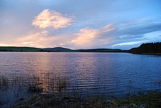
Loch Venachar is a freshwater loch in Stirling district, Scotland.

St Mary's Loch is the largest natural loch in the Scottish Borders, and is situated on the south side of the A708 road between Selkirk and Moffat, about 72 kilometres (45 mi) south of Edinburgh.
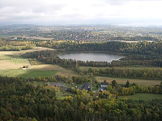
Dælivannet is a lake in Bærum, Akershus county, Norway. It lies just beneath the Kolsås hill on the East side. The lake contains perch and pike and has a rich bird life.
Loch of Aboyne is a shallow, artificial formed, freshwater loch in Grampian, Scotland. It lies 1+1⁄4 miles (2 km) northeast of Aboyne and 26 miles (42 km) west-southwest of Aberdeen. An earthen dam was constructed around 1834 to retain the loch. It also served as a reservoir for a nearby mill.

Duddingston Loch is a lake, or freshwater loch, in Edinburgh. It is one of the last two remaining natural lochs within the city, the other being Lochend Loch. It is situated to the south of Holyrood Park and lies southwest of the village of Duddingston.
Lindores Loch is a freshwater loch, situated in North Fife in the Parish of Abdie, in the Central Belt of Scotland. The Loch has for many years been used as a fishery and is well known for its abundant fish life. A curling pond is situated on the Northern shoreline and is nominally used by the Abdie Curling Club and Abdie ladies Curling Club. A speculative study suggests that the loch was created by glacial deposits from the surrounding Ochil Hills at the end of the last ice-age. The water level and shoreline have changed over time due to roads, railway, sluice gate and farmland.
Drumlough is a village/townland in County Down, Northern Ireland, southwest of Rathfriland, and is located in the civil parish of Drumgath.
Snipe Loch (NS385173) or Loch Snipe is a freshwater loch. It is situated in a low-lying area close to the B742 road next to Clocaird Farm in the Parish of Coylton, East Ayrshire, Scotland. The loch lies to the north of Martnaham Loch, 5 miles (7 km) east of Ayr.

Loch of Craiglush is a freshwater loch, located around 1+1⁄2 miles (2.4 km) north-east of Dunkeld in Perth and Kinross, Scotland. The loch is a designated Site of Special Scientific Interest (SSSI), as well as forming part of a Special Area of Conservation.

Lough Bofin is a lake on the River Shannon on the County Roscommon–County Leitrim border in Ireland.

Lough Bunny is a freshwater lake in the Burren, County Clare, Ireland.

Inchiquin Lough is a freshwater lake in the Mid-West Region of Ireland. It is located in The Burren of County Clare.

Loch Howie is a small, narrow, upland freshwater loch on the north side of Blackcraig Hill, approximately 18 miles (29 km) west of Dumfries, Scotland. The loch trends from south-west to north-east and is 0.75 mi (1.21 km) long by approximately 0.25 mi (0.40 km) at its widest point. It has an average depth of 16 ft (4.9 m) and is 39 ft (12 m) at its deepest. The loch was surveyed on 23 July 1903 by James Murray as part of Sir John Murray's Bathymetrical Survey of Fresh-Water Lochs of Scotland 1897-1909.
Lochrutton Loch is a large, lowland freshwater loch that lies to the west of Dumfries, Scotland. The loch trends from north to south and is 0.75 mi (1.21 km) long and 0.5 mi (0.80 km) at its widest point. It has an average depth of 13 ft (4.0 m) and is 58 ft (18 m) at its deepest. The loch was surveyed on 1 May 1905 by James Murray and L. W. Collett as part of Sir John Murray's Bathymetrical Survey of Fresh-Water Lochs of Scotland 1897-1909.
Rusky Castle, also known as Ruskie Castle, is a ruined castle on an islet on Loch Rusky, Stirling, Scotland. The islet is now submerged. The castle was known to be held by Sir John de Menteith.

