A crannog is typically a partially or entirely artificial island, usually built in lakes and estuarine waters of Scotland, Wales, and Ireland. Unlike the prehistoric pile dwellings around the Alps, which were built on the shores and not inundated until later, crannogs were built in the water, thus forming artificial islands.
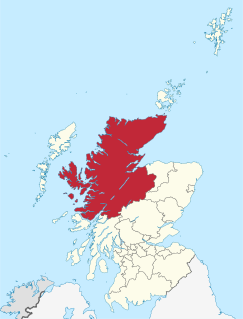
Highland is a council area in the Scottish Highlands and is the largest local government area in the United Kingdom. It was the 7th most populous council area in Scotland at the 2011 census. It shares borders with the council areas of Aberdeenshire, Argyll and Bute, Moray and Perth and Kinross. Their councils, and those of Angus and Stirling, also have areas of the Scottish Highlands within their administrative boundaries.

Loch Lomond is a freshwater Scottish loch which crosses the Highland Boundary Fault, often considered the boundary between the lowlands of Central Scotland and the Highlands. Traditionally forming part of the boundary between the counties of Stirlingshire and Dunbartonshire, Loch Lomond is split between the council areas of Stirling, Argyll and Bute and West Dunbartonshire. Its southern shores are about 23 kilometres (14 mi) northwest of the centre of Glasgow, Scotland's largest city. The Loch forms part of the Loch Lomond and The Trossachs National Park which was established in 2002.
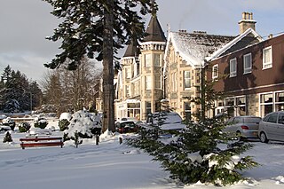
Grantown-on-Spey is a town in the Highland Council Area, historically within the county of Moray. It is located on a low plateau at Freuchie beside the river Spey at the northern edge of the Cairngorm mountains, about 20 miles (32 km) south-east of Inverness.

Loch Rannoch is a freshwater loch in Perth and Kinross, Scotland. It is over 15 kilometres (9.3 mi) long in a west–east direction with an average width of about 1.2 kilometres (0.75 mi), and is deepest at its eastern end, reaching a depth of 130 metres (440 ft). The River Tummel begins at its eastern end, where the small village of Kinloch Rannoch can be found, whilst the wild expanse of Rannoch Moor extends to the west of the loch. The area surrounding Loch Rannoch, along with Rannoch Moor itself, was formerly part of the native Caledonian Forest that stretched across much of Northern Scotland. Native forest is now largely absent from much of the area, due partly to logging, and partly to the climate becoming wetter, and Loch Rannoch is now largely surrounded by commercial forestry and open hillsides, although a small area remains at the Black Wood of Rannoch on the southern shore of the loch.
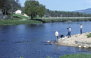
The River Spey is a river in the northeast of Scotland. It is the eighth longest river in the United Kingdom, as well as the second longest and fastest-flowing river in Scotland. It is important for salmon fishing and whisky production.

Loch Tay is a freshwater loch in the central highlands of Scotland, in the Perth and Kinross and Stirling council areas. It is the largest body of fresh water in Perth and Kinross, and the sixth largest loch in Scotland. The watershed of Loch Tay traditionally formed the historic province of Breadalbane.
The Strathspey Railway (SR) in Badenoch and Strathspey, Highland, Scotland, operates a 10 miles (16 km) heritage railway from Aviemore to Broomhill, Highland via Boat of Garten, part of the former Inverness and Perth Junction Railway which linked Aviemore with Forres. It is one of only a handful of primary/secondary main lines to be preserved in Britain today.
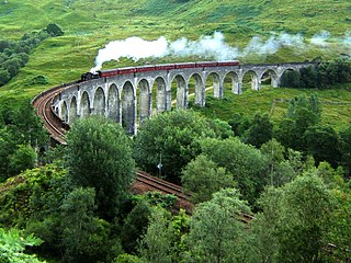
The Glenfinnan Viaduct is a railway viaduct on the West Highland Line in Glenfinnan, Inverness-shire, Scotland, built from 1897 to 1901. Located at the top of Loch Shiel in the West Highlands of Scotland, the viaduct overlooks the Glenfinnan Monument and the waters of Loch Shiel.

Loch Shiel is a freshwater loch situated 20 kilometres (12 mi) west of Fort William in the Highland council area of Scotland. At 28 kilometres long it is the 4th longest loch in Scotland, and is the longest to have retained a natural outflow without any regulation of its water level, being 120 m (393 ft) deep. Its nature changes considerably along its length, being deep and enclosed by mountains in the north east and shallow surrounded by bog and rough pasture in the south west, from which end the 4 km River Shiel drains to the sea in Loch Moidart near Castle Tioram.

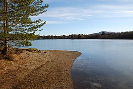
Loch Morlich is a freshwater loch in the Badenoch and Strathspey area of Highland, Scotland near Aviemore. The loch is home to a watersports centre with kayaking, sailing and windsurfing among the activities available. There is also a yacht club and cycling routes around the loch. The loch is at the foot of the Cairngorm mountains, just a few miles from Aviemore. As seen on Game of Thrones Season 5.

Loch Venachar is a freshwater loch in Stirling district, Scotland.

Loch Tummel is a long, narrow loch, seven kilometres northwest of Pitlochry in the council area of Perth and Kinross, Scotland. It is fed and drained by the River Tummel, which flows into the River Tay about 13 km (8 mi) south-east of the Clunie Dam at the loch's eastern end.

Lochspouts Loch or Lochspouts was situated in a hollow, surrounded by hilly ground on three sides and bounded by a narrow trap dyke to the north. The land was once held by the Ferguson family of Kilkerran and lies in the Parish of Kirkoswald, South Ayrshire, Scotland. The loch became a reservoir in the 19th century.
Carlingwark Loch is a small freshwater loch in the historical county of Kirkcudbrightshire, Dumfries and Galloway, Scotland lying just south of Castle Douglas and is roughly rectangular in shape, trending nearly north and south. The name of the loch comes from the Scots Gaelic word Caer meaning fort and wark the old Scots language word for work. There are four artificial islets in the loch showing evidence of fortification and settlement, Ash Island is thought to be a crannog. Several archaeological finds have been retrieved from the loch including a bronze cauldron, sword and pan and two dugout canoes.

Loch Calder is a lowland freshwater loch lying approximately 5 mi (8.0 km) south west of Thurso in the Scottish Highlands. The loch is large with an irregular shape and has perimeter of 12.8 km (8.0 mi). It is approximately 2.33 mi (3.75 km) long, has an average depth of 21 ft (6.4 m) and is 85 ft (26 m) at its deepest. The loch was surveyed on 6 October 1902 by John Parsons and T.R.H. Garrett and later charted as part of Sir John Murray's Bathymetrical Survey of Fresh-Water Lochs of Scotland 1897-1909.

Loch Teàrnait, also known as Loch Tearnait or Loch Ternate, is a small, lowland, freshwater loch on the Ardtornish Estate on the Morvern peninsula in the Scottish Highlands. It lies in an east to west direction and is approximately 6.4 km (4.0 mi) southeast of Loch Arienas and 4.8 km (3.0 mi) east of Loch Aline. It is 1.21 km (0.75 mi) long and 0.53 km (0.33 mi) wide, and is at an altitude of 141 m (463 ft). The average depth is 4.9 m (16 ft) and its maximum depth is 12 m (39 ft). The loch was surveyed on 18 August 1904 by James Murray as part of Sir John Murray's Bathymetrical Survey of Fresh-Water Lochs of Scotland 1897-1909.
Loch Freuchie, also known as Fraoch, the heatherly loch, is a large freshwater loch on a north-west to south-east orientation, within Glen Quaich in Perth and Kinross. The loch is located 2 miles (3.2 km) west of Amulree and 6.5 miles (10.5 km) southeast of Kenmore.
The Loch Arthur logboat or dugout canoe was found in 1874 when the water level was low on the south bank of the Loch Arthur, near the village of Beeswing, southwest of Dumfries in Dumfries and Galloway in Scotland. The logboat, built of oak, is about 13.7 meters long and up to 1.5 meters wide. On the opposite side of the 300 to 400 meter wide lake was a crannóg .