Back of Keppoch is a small coastal settlement in the northwest Scottish Highlands, 40 miles west of Fort William near to the A830 road to Mallaig.
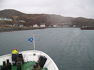
Mallaig is a port in Morar, on the west coast of the Highlands of Scotland. It faces Skye from across the Sound of Sleat. The local railway station is the terminus of the West Highland Line, and the town is linked to Fort William by the A830 road – the "Road to the Isles".
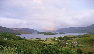
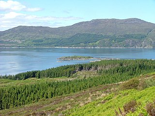
Loch Morar is a freshwater loch in Lochaber, Highland, Scotland. It is the fifth-largest loch by surface area in Scotland, at 26.7 km2 (10.3 sq mi), and the deepest freshwater body in the British Isles with a maximum depth of 310 m (1,017 ft). The loch was created by glacial action around 10,000 years ago, and has a surface elevation of 9 metres (30 ft) above sea level. It separates the traditional district of North Morar, from Arisaig and Moidart.

Crianlarich is a village in Stirling council area and in the registration county of Perthshire, Scotland, around 6 miles (10 km) north-east of the head of Loch Lomond. The village bills itself as "the gateway to the Highlands".

The A830, also known as the Road to the Isles is a major road in Lochaber, Scottish Highlands. It connects the town of Fort William to the port of Mallaig.

Morar is a small village on the west coast of Scotland, 3 miles (5 km) south of Mallaig. The name Morar is also applied to the northern part of the peninsula containing the village, though North Morar is more usual. The coastline of the area forms part of the Morar, Moidart and Ardnamurchan National Scenic Area, one of 40 such areas in Scotland, which are defined so as to identify areas of exceptional scenery and to ensure its protection by restricting certain forms of development.

Ben Ledi is a mountain in Stirling, Scotland. It is 879 metres high, and is therefore classified as a Corbett. It lies about six kilometres northwest of Callander, near the village of Kilmahog. It is situated in the Trossachs, an area often regarded as having some of the most romantic scenery in the Highlands.

Mallaig railway station is a railway station serving the ferry port of Mallaig, Lochaber, in the Highland region of Scotland. This station is a terminus on the West Highland Line, 41 miles (66 km) by rail from Fort William and 164 miles (264 km) from Glasgow Queen Street. The station building is Category C listed. ScotRail, who manage the station, operate most of the services.
The Northwest Highlands are located in the northern third of Scotland that is separated from the Grampian Mountains by the Great Glen. The region comprises Wester Ross, Assynt, Sutherland and part of Caithness. The Caledonian Canal, which extends from Loch Linnhe in the south-west, via Loch Ness to the Moray Firth in the north-east splits this area from the rest of the country. The city of Inverness and the town of Fort William serve as gateways to the region from the south.
Tarbet is a place on the south shore of Loch Nevis in Scotland, about 6 miles east of Mallaig. The name 'tarbet' refers to a portage or isthmus, in this case it is between Loch Nevis and Loch Morar.

A water horse is a mythical creature, such as the Ceffyl Dŵr, Capaill Uisce, the bäckahäst and kelpie.

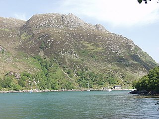
Loch Nevis is a sea loch in Lochaber on the west coast of Scotland.
The Sound of Sleat is a narrow sea channel off the western coast of Scotland. It divides the Sleat peninsula on the south-east side of the Isle of Skye from Morar, Knoydart and Glenelg on the Scottish mainland.
The Breadalbane Hydro-Electric Scheme is a hydroelectric scheme in the Breadalbane area of Perthshire, Scotland. It comprises seven power stations which generate 120MW of power from the dams around Loch Lyon, Loch Earn and Loch Tay.

The River Morar is a river that flows from Loch Morar in the west Highlands of Scotland. It flows from the western end of the loch to the estuary of Morar Bay, an inlet of the Sound of Sleat. It is one of Scotland's shortest rivers, and is known for its white sands beaches where it flows through Morar Bay.

The Morar Railway Viaduct is a railway viaduct that carries the West Highland Line over the River Morar.

Rhu Peninsula and originally known as the Rhu Arisaig peninsula is a small, remote and largely deserted peninsula, at the SW corner of South Morar in Lochaber Highland council area, on the west coast of Scotland. Arisaig is located at the northeast corner of the peninsula. In July 1745, Loch nan Uamh on the south coast of the peninsula was the landing spot for Prince Charles Edward Stuart.

Loch a' Ghille Ghobhaich is a large irregular shaped freshwater loch on a north-south orientation, that lies about a half-mile north of the west-end of Loch Morar and is south-by-southeast of Mallaig in the Lochaber district of Scotland.