
Loch Maree is a loch in Wester Ross in the Northwest Highlands of Scotland. At 21.7 km (13.46 mi) long and with a maximum width of four kilometres, it is the fourth-largest freshwater loch in Scotland; it is the largest north of Loch Ness. Its surface area is 28.7 km2 (11.08 sq mi).

Dunkeld is a town in Perth and Kinross, Scotland. The location of a historic cathedral, it lies on the north bank of the River Tay, opposite Birnam. Dunkeld lies close to the geological Highland Boundary Fault, and is frequently described as the "Gateway to the Highlands" due to its position on the main road and rail lines north. Dunkeld has a railway station, Dunkeld & Birnam, on the Highland Main Line, and is about 25 kilometres north of Perth on what is now the A9 road. The main road formerly ran through the town, however following modernisation of this road it now passes to the west of Dunkeld.
Loch of the Lowes is a loch near Dunkeld in Perth and Kinross, Scotland. The loch and the surrounding area are designated as a wildlife reserve, run by the Scottish Wildlife Trust. The loch is also a designated Site of Special Scientific Interest (SSSI), as well as forming part of a Special Area of Conservation.

Loch Dùghaill is a freshwater tidal loch on the River Carron in Wester Ross, Scotland. The A890 road and the Kyle of Lochalsh Line a branch of the Highland railway both run along its northwest shore. Loch Carron is located 8 km downriver.

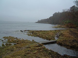
Loch Alsh is a sea inlet between the isle of Skye in the Inner Hebrides and the Northwest Highlands of Scotland. The name is also used to describe the surrounding country and the feudal holdings around the loch. The area is rich in history, and is increasingly popular with tourists.

Loch Ness is a large freshwater loch in the Scottish Highlands extending for approximately 37 kilometres southwest of Inverness. It takes its name from the River Ness, which flows from the northern end. Loch Ness is best known for alleged sightings of the cryptozoological Loch Ness Monster, also known affectionately as "Nessie". It is one of a series of interconnected, murky bodies of water in Scotland; its water visibility is exceptionally low due to a high peat content in the surrounding soil. The southern end connects to Loch Oich by the River Oich and a section of the Caledonian Canal. The northern end connects to Loch Dochfour via the River Ness, which then ultimately leads to the North Sea via the Moray Firth.

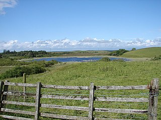
Rescobie Loch is a post glacial fresh water body located in the parish of Rescobie, 4 km (2.5 mi) to the East of Forfar, in the county of Angus, Scotland. The loch is fed by Lunan Water which enters from the West and exits to the East.

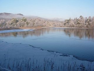
Loch of Craiglush is a freshwater loch, located around 1+1⁄2 miles (2.4 km) north-east of Dunkeld in Perth and Kinross, Scotland. The loch is a designated Site of Special Scientific Interest (SSSI), as well as forming part of a Special Area of Conservation.

Strachur Bay is a coastal embayment, on a 114° orientation, on the eastern coast of the longest sea loch in Scotland, Loch Fyne located in Argyll and Bute, on the west coast of Scotland. Strachur Bay provides good anchorage, for small vessels, when the wind is from the northeast and southeast.
Achagoyle Bay is coastal embayment, on a chord of 0.75 miles, on a 114° orientation, on the western coast of the longest sea loch in Scotland, Loch Fyne located in Argyll and Bute, on the west coast of Scotland. Achagoyle Bay is directly northwest of Brainport Bay on a NNE orientation, which forms a rightward hook, and opens into the Minard Bay with a NE orientation, also with a rightward hook, directly south. The three bays constitute the western edge of the Minnow Narrows which is bounded by the islands An Oitir and Eilean Aoghainn directly to the east of Brainport Bay.
Barhapple Loch is a small semicircular freshwater loch located in Wigtownshire, Dumfries and Galloway in Scotland. Barhapple Loch is principally known for the discovery of a Crannog in 1878 on the loch, when it was drained.

Loch a' Bhraoin, Loch Broom, is a freshwater loch, located in Wester Ross, in Ross-shire, on the west coast of Scotland.
Fingask Loch is a small lowland freshwater loch that is about three-quarters of a mile from Rae Loch in the valley of the Lunan Burn and is 1.5 miles south-east of Blairgowrie, in Perth and Kinross. Directly to the east is the smaller White Loch, and next to it is the Black Loch.

White Loch is a small lowland freshwater loch that is located directly to the east of Fingask Loch in the valley of the Lunan Burn and is 1.5 miles south of Blairgowrie, in Perth and Kinross. The loch is also a designated Site of Special Scientific Interest (SSSI), as well as forming part of a Special Area of Conservation.

Black Loch is a small lowland freshwater loch that is located directly to the east of Fingask Loch in the valley of the Lunan Burn and is 1 mile south of Blairgowrie, in Perth and Kinross.

Loch Turret is a large freshwater reservoir on a north-east to south-west orientation, that is located at the head of Glen Turret and 5.39 miles (8.67 km) northwest of Crieff in Perth and Kinross.
Pond of Drummond is a small shallow freshwater artificial loch in the grounds of Drummond Castle, and is orientated on an east to west orientation, being located 2 miles southeast of Crieff in Perth and Kinross.

Loch Leitir Easaidh is a small shallow irregular shaped freshwater lochan that flows directly into the northwestern end of Loch Assynt in Assynt, Sutherland, Scotland. The loch is located in an area along with neighbouring Coigach, as the Assynt-Coigach National Scenic Area, one of 40 such areas in Scotland.

Fionn Loch is a small irregular-shaped shallow freshwater loch, on a north-west to south-east orientation that is located 3 miles southeast of Lochinver in the Assynt district of Sutherland in Scotland. Fionn Loch drains through the River Kirkaig and flows over the Falls of Kirkaig before reaching the sea.


