
Perthshire, officially the County of Perth, is a historic county and registration county in central Scotland. Geographically it extends from Strathmore in the east, to the Pass of Drumochter in the north, Rannoch Moor and Ben Lui in the west, and Aberfoyle in the south; it borders the counties of Inverness-shire and Aberdeenshire to the north, Angus to the east, Fife, Kinross-shire, Clackmannanshire, Stirlingshire and Dunbartonshire to the south and Argyllshire to the west. It was a local government county from 1890 to 1930.

The national nature reserves (NNRs) of Scotland are areas of land or water designated under the Wildlife and Countryside Act 1981 as containing habitats and species of national importance. National nature reserves can be owned by public, private, community or voluntary organisations but must be managed to conserve their important habitats and species, as well as providing opportunities for the public to enjoy and engage with nature. There are currently 43 NNRs in Scotland, which cover 154,250 hectares (1,542.5 km2), or less than 1.5% of the land area of Scotland. They range in size from Corrieshalloch Gorge at 7 ha to Mar Lodge Estate, which covers 29,324 ha.

Perth and Kinross is one of the 32 council areas of Scotland and a Lieutenancy Area. It borders onto the Aberdeenshire, Angus, Argyll and Bute, Clackmannanshire, Dundee, Fife, Highland and Stirling council areas. Perth is the administrative centre. With the exception of a large area of south-western Perthshire, the council area mostly corresponds to the historic counties of Perthshire and Kinross-shire.

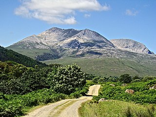
The River Tay is the longest river in Scotland and the seventh-longest in the United Kingdom. The Tay originates in western Scotland on the slopes of Ben Lui, then flows easterly across the Highlands, through Loch Dochart, Loch Iubhair and Loch Tay, then continues east through Strathtay, in the centre of Scotland, then southeasterly through Perth, where it becomes tidal, to its mouth at the Firth of Tay, south of Dundee. It is the largest river in the UK by measured discharge. Its catchment is approximately 2,000 square miles (5,200 km2), the Tweed's is 1,500 square miles (3,900 km2) and the Spey's is 1,097 square miles (2,840 km2).

Blairgowrie and Rattray is a twin burgh in Perth and Kinross, Scotland. Locals refer to the town as "Blair". Blairgowrie is the larger of the two former burghs which were united by an Act of Parliament in 1928 and lies on the southwest side of the River Ericht while Rattray is on the northeast side. Rattray claims to be the older and certainly Old Rattray, the area round Rattray Kirk, dates back to the 12th century. New Rattray, the area along the Boat Brae and Balmoral Road dates from 1777 when the River was spanned by the Brig o' Blair. The town lies on the north side of Strathmore at the foot of the Grampian Mountains. The west boundary is formed by the Knockie, a round grassy hill, and Craighall Gorge on the Ericht. Blairgowrie and Rattray developed over the centuries at the crossroads of several historic routes with links from the town to Perth, Coupar Angus, Alyth and Braemar. The roads to Coupar Angus and Braemar form part of General Wade's military road from Perth to Fort George. The town's centrepiece is the Wellmeadow, a grassy triangle in the middle of town which hosts regular markets and outdoor entertainment.

Loch Lomond and The Trossachs National Park is a national park in Scotland centred on Loch Lomond and the hills and glens of the Trossachs, along with several other ranges of hills. It was the first of the two national parks established by the Scottish Parliament in 2002, the second being the Cairngorms National Park. The park extends to cover much of the western part of the southern highlands, lying to the north of the Glasgow conurbation, and contains many mountains and lochs. It is the fourth largest national park in the British Isles, with a total area of 1,865 km2 (720 sq mi) and a boundary of some 350 km (220 mi) in length. It includes 21 Munros and 20 Corbetts.
Beinn Eighe is a complex mountain massif in the Torridon area of Wester Ross in the Highlands of Scotland. Lying to the south of Loch Maree, it forms a long ridge with many spurs and summits, two of which are classified as Munros. The name Beinn Eighe comes from the Scottish Gaelic meaning File Mountain. Unlike most other hills in the area it has a cap of Cambrian basal quartzite which gives the peaks of Beinn Eighe a distinctive light colour. Its complex topography has made it popular with both hillwalkers and climbers and the national nature reserve on its northern side makes it an accessible mountain for all visitors.

Loch Fleet is a sea loch on the east coast of Scotland, located between Golspie and Dornoch. It forms the estuary of the River Fleet, a small spate river that rises in the hills east of Lairg. The loch was designated a National Nature Reserve (NNR) in 1998, and is managed by a partnership between Scottish Natural Heritage (SNH), the Scottish Wildlife Trust (SWT) and Sutherland Estates. The NNR extends to 1058 hectares, including the Loch Fleet tidal basin, sand dunes, shingle ridges and the adjacent pine woods, including Balbair Wood and Ferry Wood. The tidal basin of the loch covers over 630 ha, and forms the largest habitat on the NNR.
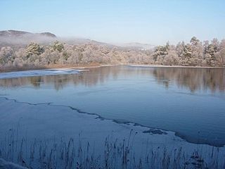
Loch of the Lowes is a loch near Dunkeld in Perth and Kinross, Scotland. The loch and the surrounding area are designated as a wildlife reserve, run by the Scottish Wildlife Trust. The loch is also a designated Site of Special Scientific Interest (SSSI), as well as forming part of a Special Area of Conservation.
Muir of Dinnet is a national nature reserve (NNR) situated close to the village of Dinnet in Aberdeenshire, Scotland. The reserve extends 1166 hectares from the River Dee to Culbean hill, and encompasses a wide range of habitats including dry heath, raised bog, woodland, and two lochs: Loch Kinord and Loch Davan. Muir of Dinnet was first declared a NNR in 1977 due to its value as a habitat for flora and fauna, and its important geomorphological features, the most striking of which is the Burn O'Vat. Muir of Dinnet is owned by Dinnet Estate and managed by Scottish Natural Heritage (SNH), who provide a visitor centre and a range of other facilities including waymarked paths and a car park. As of 2012 SNH estimated that approximately 40,000 people visited Muir of Dinnet each year.

Loch Creran is a sea loch in Argyll, on the west coast of Scotland. It is about 10 kilometres (6.2 mi) long from its head at Invercreran to its mouth on the Lynn of Lorne, part of Loch Linnhe. The loch separates the areas of Benderloch to the south and Appin to the north. The island of Eriska lies at the mouth of the loch. The loch is bridged at its narrowest point at Creagan, by the A828 road. The village of Barcaldine lies on the south shore of the loch.
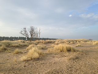
Tentsmuir National Nature Reserve (NNR) is located southeast of Tayport in Fife, Scotland. The reserve is made up of three parts, encompassing Morton Lochs, Tentsmuir Point and Tayport Heath, and is managed by Scottish Natural Heritage (SNH). The different sections of Tentsmuir NNR were originally designated as separate national nature reserves at different times: The Morton Lochs section was designated in 1952; Tentsmuir, in 1954; and Tayport Heath, in 1988. While these discrete sections are distant from one another, they form part of the extensive dune system at Tentsmuir, and in 2003 SNH combined the three sites to become Tentsmuir National Nature Reserve. The adjoining Tentsmuir Forest is managed by Forestry and Land Scotland and covers most of the land between the three portions of the NNR.

Loch of Craiglush is a freshwater loch, located around 1 1⁄2 miles (2.4 km) north-east of Dunkeld in Perth and Kinross, Scotland. The loch is a designated Site of Special Scientific Interest (SSSI), as well as forming part of a Special Area of Conservation.

Loch Lomond National Nature Reserve (NNR) encompasses 430 hectares of land at the southeastern part of Loch Lomond in the council areas of Stirling and West Dunbartonshire, in Scotland. It covers the islands of Inchcailloch, Clairinsh, Torrinch, Creinch and Aber Isle, alongside areas of woodland and wetlands to either side of the mouth of the Endrick Water. Scottish Natural Heritage (SNH) owns two parts of the reserve - the island of Inchcailloch and part of Gartfairn Wood - and the rest is privately owned. The reserve is managed by a partnership consisting of SNH, the Royal Society for the Protection of Birds (RSPB) and the Loch Lomond and The Trossachs National Park, along with the owners and tenants of the land under agreements. Within this framework SNH directly manage the islands of Clairinsh, Inchcailloch, Torrinch and Creinch, and land to the north of the Endrick Water. The RSPB manages the area to the south of the Endrick Water, and the National Park manages visitor facilities on Inchcailloch.

Rae Loch is a small lowland freshwater loch that sits directly to the east of Loch of Drumellie into which it flows and is 1.5 miles to the west of Blairgowrie, in Perth and Kinross.. The loch is also a designated Site of Special Scientific Interest (SSSI), as well as forming part of a Special Area of Conservation.

Fingask Loch is a small lowland freshwater loch that is about three-quarters of a mile from Rae Loch in the valley of the Lunan Burn and is 1.5 miles south-east of Blairgowrie, in Perth and Kinross. Directly to the east is the smaller White Loch, and next to it is the Black Loch.

White Loch is a small lowland freshwater loch that is located directly to the east of Fingask Loch in the valley of the Lunan Burn and is 1.5 miles south of Blairgowrie, in Perth and Kinross.The loch is also a designated Site of Special Scientific Interest (SSSI), as well as forming part of a Special Area of Conservation.

Black Loch is a small lowland freshwater loch that is located directly to the east of Fingask Loch in the valley of the Lunan Burn and is 1 mile south of Blairgowrie, in Perth and Kinross.
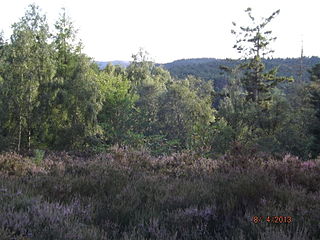
Stormont Loch is a small irregular lowland freshwater loch, that is partially in-filled. It located in a nature reserve owned by the Scottish Wildlife Trust, on a north-east to south-west orientation and is 2 miles southeast of Blairgowrie in Perth and Kinross.

Monk Myre is a small shallow freshwater lochan and is located 2.5 miles southeast of Blairgowrie in Perth and Kinross.

