Lochlea, South Ayrshire

Last updated

Lochlea, also Lochlie
Small loch at Lochlea - geograph.org.uk - 308390.jpg
Lochlea
South Ayrshire UK relief location map.jpg
Red pog.svg
Lochlea, also Lochlie
Location Tarbolton, South Ayrshire, Scotland
Coordinates 55°32′31.2″N4°26′50.6″W / 55.542000°N 4.447389°W / 55.542000; -4.447389
Type Drained freshwater loch
Primary inflows Rainfall and runoff
Primary outflows Mill Burn
Basin  countriesScotland
Max. length950 m (3,120 ft)
Max. width1,450 ft (440 m)
Surface area19.675 acres (8 ha) [1]
Surface elevation400 ft (120 m)
Islands One
Settlements Tarbolton

Lochlea or Lochlie (pronounced 'Lochli') was situated in a low-lying area between the farms and dwellings of Lochlea and Lochside in the Parish of Tarbolton, South Ayrshire, Scotland. The loch was natural, sitting in a hollow created by glaciation. The loch waters ultimately drained via Fail Loch, the Mill Burn, and the Water of Fail. It is well-documented due to the presence of a crannog that was excavated and documented circa 1878, and its association with the poet Robert Burns, who lived here for several years whilst his father was the tenant. [2] [3] Lochlea lies 2+12 miles (4 kilometres) northeast of Tarbolton, and just over three miles (five kilometres) northwest of Mauchline.

Contents

History

The loch also recorded as 'Lochly', [4] 'Lochlee' [5] and 'Lochlie' may derive its name from 'Liath', Gaelic for the 'Grey Loch'. [6] It was once much more extensive, and changes in the water level are indicated by the successive alterations identified within the site's crannog. [7]

The Water of Fail near Fail Castle Cottage Water of Fail at Fail.JPG
The Water of Fail near Fail Castle Cottage

The Duke of Portland abolished thirlage on his estates in the mid-19th century, making Millburn Mill, and its head of water, Lochlea, redundant, [8] [9] resulting in active attempts at drainage causing its demise circa 1840. The lands became part of the fields of Lochlea Farm. [2] Adamson records that the loch was drained in 1839, during which two canoes were found near the crannog. [10] The waters still contributed to the flow to Fail Mill that stood on the rivulet of the Water of Fail. This mill survived into the 20th century. Much of the surrounding lands in the area and those of Lochlea originally belonged to the monks of Fail Monastery. [8] The natural drainage, the Mill Burn, was from the south-east corner, running into a narrow valley that ran eventually into Fail Loch. [11]

William Muir was the tenant of the Mill of Fail at the time of Robert Burns. [12]

Blaeu's map of 1654 clearly shows the loch and indicates that it was somewhat smaller, less than half the size, of Fail Loch. [13] Roy's map of 1747 shows the loch and indicates a 'Lochleehill'. [14] Thomson records a 'Lochbar'. [4]

In 1842 drainage was underway and it was being converted into arable land and the associated mill was abandoned. [5]

The early Ordnance Survey maps show the site as fully drained, [15] however drainage is now inadequate and the area is becoming re-established as a seasonal loch. [16]

Shaw relates in the 1950s that "Lochlee, Fail Loch and Tarbolton Loch are no longer so full of water as when they were required to supply water for the meal mills, and gave good skating and curling in a hard winter. They are now to a large extent drained away, but are still the haunt of snipe, goose, duck, and swan." [17]

Drainage

Although the loch's drainage may have begun in the 18th century when Alexander Montgomerie, 10th Earl of Eglinton, was pursuing a number of agricultural improvements on his extensive estates and other landowners followed his example, drainage work may have taken place in the 1740s as part of the improvements undertaken to provide employment for Irish estate workers during the Irish potato famines of the 1740s and the mid 19th centuries. Many drainage schemes also date to the end of World War I when many soldiers returned en masse to civilian life. [18]

The loch may have survived during the Burns family's time as Robert and Gilbert grew flax and probably used the loch as a retting pond for the preparation of the flax. [19]

The crannog

This artificial island was mainly visible in the summer months and lay about 75 yards from the southern bank of the loch. Despite its prominence during Robert Burns's time, he made no recorded reference to it. [2] A wooden walkway ran to it from the south-east side of the loch. [7] At least five dugout canoes were found, some distance from the crannog. [20] [21] The land had become marshy again by 1878 [22] and the re-discovery at this time generated enough interest to spark an excavation; [21] the site and Lochlea Farm were owned by the Duke of Portland and Mr Turner, his factor, helped to organise the excavations, together with Mr. Cochrane-Patrick of Woodside, Beith. [23] Much of the wood associated with the crannog was that of oak, hazel and birch, [24] together with alder and poplar. [25] Animals present included sheep, roe deer, red deer, reindeer, pig, and horse. [26]

The crannog had several separate periods of occupation. Among the finds was a 9th-century ringed pin, and also several finds of 16th- or 17th-century origin, such as a brass mounted knife and a number of iron implements. It measured overall circa 33 m east–west by 23 m transversely, with its centre at NS 4574 3027. [1]

Lochlea Farm Lochlea Farm - geograph.org.uk - 3539.jpg
Lochlea Farm
Scotland relief location map.jpg
Red pog.svg
Lochlea
Previous location of Lochlea, South Ayrshire

The Burns family connection

Lochlie or Lochlea, Robert Burns used both versions, became his home in 1777 when his father William Burnes moved here from Mount Oliphant. The 130-acre farm and loch were owned by David McLure, an Ayr merchant. Burns moved to Mossgiel Farm near Mauchline in 1784, having spent some nine unhappy months away in Irvine learning flax processing. The farmland was very mossy and William Burnes had problems paying his rather high rent resulting in a successful court case against the landlord that used up his savings and contributed to his premature death in February 1784. [27] Burns is said to have roofed the barn himself and upon its demolition an engraved lintel from it was incorporated into the new farmhouse that replaced it. In 1879 the poet's home had become a barn. [28]

William Burnes had a verbal agreement in the early 1780s to pay rent on the mill dam, referring to the land covered by the loch. David McClure had not yet drained this land and therefore William disputed the payment. [29]

In Burns's day Lochlea was one of three plains that were deliberately flooded in winter to provide water to power the mill that only worked in winter once the harvest was in. Lochlea Loch had an acreage of twenty and its small island was a breeding site for watefowl. [30]

William Ronald was a gauds boy to Burns at Lochlea Farm, assisting him with the ploughing by encouraging and guiding the horses whilst carrying a plough staff to clean the ploughshare when it clogged with earth. He later became a farmer at Mauleside, a small estate near Beith on the road from Dalry. [31]

Isabella Burns recounted from memory the nursery story The Marriage of Robin Redbreast and the Wren that Robert Burns had written and used at Lochlea Farm to entertain his young siblings Annabella, William and John.

The Burns family left Lochlea in 1784 and moved to Mossgiel Farm near Mauchline. [32]

Highland Mary

Burns met Mary Campbell aka 'Highland Mary' in church while he was living near Tarbolton. His song "Will ye go to the Indies, my Mary, And leave auld Scotia's shore?" suggests that they planned to emigrate to Jamaica together, however after a brief illness she died at Greenock. Burns and Mary Campbell apparently exchanged Bibles over a water course in the area around Coilsfield or Failford and possibly some sort of traditional Scottish matrimonial vows [33] on the banks of the River Ayr, either at the Failford, where the Mauchline Burn has its confluence with the River Ayr, or near Coilsfield. [34]

Lochlea Whisky

The farm released its first own whisky. It is called "Lochlea First Release" and was matured in First Fill Bourbon and Pexdro Ximenez (PX) Casks. At first it was released in scotland and then sold worldwide. [35] [36] In March 2022, the distillery announced the release of a four bottle strong limited edition series. The first bottling of the series, the "Lochlea Sowing Edition (First Crop)" is announced for March 21, 2022. Lochlea announced the end of the four quarterly "Seasonal Releases" in April 2024. [37] [38] The distillery has also announced the release of its core release "Lochlea Our Barley" for summer 2022. [39] [40] [41] At the beginning of 2023, the distillery released its first peaty whisky, the "Lochlea Ploughing Edition First Crop". [42] The first cask strength Lochlea Whisky will be released on 31 March 2023. [43]

Micro-history

James Thom was born near Lochlea and went on to become a famous sculptor of Robert Burns and his contemporaries. [3]

Lochlea 1 & 2 collieries were situated in the vicinity of the farm and operated from 1949 to 1973. Little visible remains survive. [44]

Lochlea is the site of a wildfowl Wetland Bird Survey (WEBS) count. [45]

Related Research Articles

<span class="mw-page-title-main">Lowland single malts</span> Region of Scotch whisky production

Lowland single malts are single malt whiskies distilled in Scotland's lowlands. The region is home to distilleries such as: Annandale Distillery in Annan; Auchentoshan near Clydebank; Bladnoch in Galloway; Daftmill in Fife; The Girvan Distilleries near Girvan; and Glenkinchie distillery near Edinburgh.

Glenbuck is a small, remote village in East Ayrshire. It is nestled in the hills 3 miles (5 km) east of Muirkirk, East Ayrshire, Scotland.

<span class="mw-page-title-main">Tarbolton</span> Human settlement in Scotland

Tarbolton is a village in South Ayrshire, Scotland. It is near Failford, Mauchline, Ayr, and Kilmarnock. The old Fail Monastery was nearby and Robert Burns connections are strong, including the Bachelors' Club museum.

Riccarton is a village and parish in East Ayrshire, Scotland. It lies across the River Irvine from Kilmarnock, this river forming the boundary between Riccarton and Kilmarnock parishes, and also between the historical districts of Kyle and Cunningham. The name is a corruption of 'Richard's town', traditionally said to refer to Richard Wallace, the uncle of Sir William Wallace. The parish also contains the village of Hurlford.

<span class="mw-page-title-main">The Lands of Lochridge</span> Village in East Ayrshire, Scotland, UK

The Lochridge estate was in the old feudal Baillerie of Cunninghame, near Stewarton in what is now East Ayrshire, Scotland.

<span class="mw-page-title-main">Failford</span>

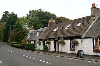
Failford is a hamlet in South Ayrshire, Scotland. It is 4 kilometres (2.5 mi) west of Mauchline, where the Water of Fail flows into the River Ayr.

<span class="mw-page-title-main">Fail Monastery</span> Former monastery in Ayrshire, Scotland

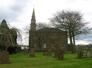
Fail Monastery, occasionally known as Failford Abbey, had a dedication to 'Saint Mary', and was located at Fail on the bank of the Water of Fail, Parish of Tarbolton near the village of Tarbolton, South Ayrshire. Most of the remaining monastery ruins were removed in 1952. The official and rarely used title was House of the Holy Trinity of Failford or the Ministry of Failford.

<span class="mw-page-title-main">Loch Brand</span> Drained freshwater loch in North Ayrshire, Scotland

Loch Brand or Loch of Boghall was a loch situated in a depression between the Grange Estate, Crummock, Hill of Beith Castle site and Boghall in the Parish of Beith, North Ayrshire, Scotland. The loch was fed by the Grange Burn and surface runoff, such as from the old rig and furrows indicated by Roy's Maps of the mid 17th century. The loch was drained by the Boghall Burn that runs passed the 'Court Hill' and into Powgree Burn at Gateside.

<span class="mw-page-title-main">Buiston Loch</span> An occasional lake in Ayrshire, Scotland

Buiston Loch, also known as Buston, Biston and Mid Buiston, was situated in the mid-Ayrshire clayland at an altitude of 90 m OD. The loch was natural, sitting in a hollow created by glaciation. The loch waters drained via the Garrier Burn that joins the Bracken and Lochridge Burns before joining the River Irvine.

<span class="mw-page-title-main">Loch Brown</span> Drained freshwater loch in East Ayrshire, Scotland

Loch Brown, also known in Scots as Loch Broun, Broon or Broom, was situated in a kettle hole in the mid-Ayrshire clayland near Crosshands. It is nowadays (2011) visible as a surface depression in pastureland, partially flooded, situated in a low-lying area close to farms and dwellings of Skeoch, Dalsangan, Ladebrae, Lochhill, and Crosshands, mainly in the Parish of Mauchline and partly in Craigie, East Ayrshire, Scotland. Duveloch is an old name for the loch and this may derive from the Gaelic Dubh, meaning black or dark loch.

<span class="mw-page-title-main">Helenton Loch</span> Drained freshwater loch in South Ayrshire, Scotland

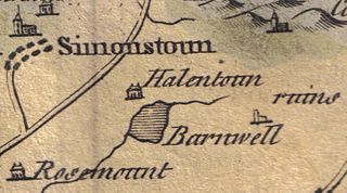
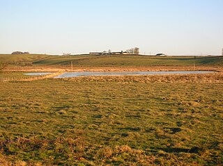
Helenton Loch was situated in a low lying area between the farms and dwellings of Helentongate, Mains, and Burnbank in the Parish of Symington, South Ayrshire, Scotland. The loch was natural, sitting in a hollow, a kettle hole, created by glaciation. The loch waters ultimately drained via the Pow Burn. Helenton Hill is a prominent landmark to the west of the old loch site. The nearby lands of Rosemount were in 1549 known as 'Goldring' and were the property of the Schaws of Sornbeg.

<span class="mw-page-title-main">Fail Loch</span> Drained freshwater loch in South Ayrshire, Scotland

Fail Loch or Faile Loch was situated in a low-lying area near the old monastery of Fail in the Parish of Tarbolton, South Ayrshire, Scotland. The old Lochlea Loch lies nearby and its waters still feed into Fail Loch via the Mill Burn.

<span class="mw-page-title-main">Loch of Trabboch</span> Drained freshwater loch in East Ayrshire, Scotland

The Loch of Trabboch or Dalrympleston Loch (NS440211) was situated in a low-lying area below the old Castle of Trabboch, once held by the Boyd family in the Parish of Stair, East Ayrshire, Scotland.

<span class="mw-page-title-main">Lochspouts</span> Drained freshwater loch in South Ayrshire, Scotland

Lochspouts Loch or Lochspouts was situated in a hollow, surrounded by hilly ground on three sides and bounded by a narrow trap dyke to the north. The land was once held by the Ferguson family of Kilkerran and lies in the Parish of Kirkoswald, South Ayrshire, Scotland. The loch became a reservoir in the 19th century.

<span class="mw-page-title-main">Martnaham Loch</span> Freshwater loch in South Ayrshire, Scotland

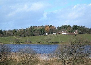
Martnaham Loch is a freshwater loch lying across the border between East and South Ayrshire Council Areas, two kilometres from Coylton, in the parishes of Coylton and Dalrymple, three miles from Ayr. The loch lies along an axis from northeast to southwest. The remains of a castle lie on a possibly artificial islet within the loch. The Campbells of Loudoun once held the lands, followed by the Kennedys of Cassillis.

<span class="mw-page-title-main">John MacKenzie (doctor)</span> Scottish army surgeon

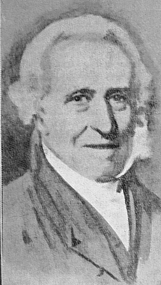
John MacKenzie (c.1755–1837) was a Scottish army surgeon. He was a native of Ayrshire, where he married Helen Miller (d.1827), one of the "Six proper Mauchline belles" who is buried in Irvine's Old Parish church. He was a member with Robert Burns of the St James Lodge, Tarbolton. His house in Mauchline is now the 'Burns House Museum,' run by East Ayrshire Council. MacKenzie wrote "Origin of Morals and Common Sense".

<span class="mw-page-title-main">Irvine Burns Club</span> Association which celebrates Robert Burns and Scottish literature

The Irvine Burns Club, based at the Wellwood Burns Centre & Museum, was founded on 2 June 1826 and is one of the world's longest continuously active Burns Clubs. At least five personal friends of Robert Burns were among the group of local gentleman, whose idea it was to form the club. Irvine in North Ayrshire is an old market town and port situated on the west coast of Scotland, approx 14 miles north of Ayr.

<span class="mw-page-title-main">William Burnes</span>

William Burnes or William Burness was the father of the poet Robert Burns. He was born at either Upper Kinmonth or Clochnahill Farm, Dunnottar, Kincardineshire, and trained as a gardener at Inverugie Castle, Aberdeenshire, before moving to Ayrshire and becoming a tenant farmer. His parents were Robert Burnes and Isabella Keith. He retained the spelling 'Burnes' throughout his life; however, his son favoured the Ayrshire spelling of 'Burns'.

<span class="mw-page-title-main">Newton Loch, South Ayrshire</span> Drained freshwater loch in South Ayrshire, Scotland

Newton Loch was situated in a low-lying area near Newton-on-Ayr, South Ayrshire, just south of the old South and West Sanquhar Farms. It is now (2016) only visible as remnant heath land and surface darkening in pastureland, situated mainly in the Parish of Ayr and partly in St Quivox, South Ayrshire, Scotland.

<span class="mw-page-title-main">Kate Kemp</span> Poets muse

Kate Kemp of Barskimming lived with her father at the Bridge House on the northern side of the single span Barskimming Old Bridge, River Ayr, Scotland. Both Robert Burns and James Andrew, the miller at Barskimming Mill, had a romantic interest in her and one visit led to the composition of the poem and dirge "Man was made to Mourn".

References

Notes
  1. 1 2 RCAHMS Retrieved : 2011-01-04
  2. 1 2 3 Arch Hist Coll, p. 30
  3. 1 2 Love, p. 210
  4. 1 2 Thomson's Map Retrieved : 2011-01-04
  5. 1 2 Dillon, p.118
  6. Place Names in the Land o'Burns Retrieved: 2011-01-04
  7. 1 2 Smith. p. 144
  8. 1 2 Paterson, p. 751
  9. Arch Hist Coll, p. 87
  10. Adamson, p. 104
  11. Arch Hist Coll, p. 86
  12. The Book of Robert Burns. Accessed : 2010-07-02
  13. Blaeu's Map Retrieved : 2011-01-04
  14. Roy's Map Retrieved : 2011-01-04
  15. NLS Maps Archived 2011-04-11 at the Wayback Machine Retrieved : 2011-01-04
  16. Google Maps Retrieved : 2011-01-04
  17. Smith, p. 60
  18. MacIntosh, pp. 37, 39
  19. Boyle, p. 89
  20. Smith, p. 145
  21. 1 2 Campbell, p. 218
  22. Adamson, p. 105
  23. Arch Hist Coll, p. 31
  24. Arch Hist Coll, p. 32
  25. Arch Hist Coll, p. 82
  26. Arch Hist Coll, pp. 80-81
  27. Robert Burns Country Retrieved : 2011-01-06
  28. Adamson, p. 106
  29. McKay, p. 113
  30. Lowe, p. 49
  31. Boyle, p. 102
  32. McKay, p. 52
  33. Burns Encyclopedia Retrieved : 17 March 2012
  34. Hecht, p. 86
  35. "Our First Release". 1 February 2022. Retrieved 4 February 2022.
  36. "Lochlea First Release demnächst auch hierzulande erhältlich". 27 January 2022. Retrieved 4 February 2022.
  37. "Lochlea nimmt "Seasonal Releases" vom Markt • CaptainScotch.de". CaptainScotch.de (in German). 13 April 2024. Retrieved 13 April 2024.
  38. Bowes, Lauren (8 April 2024). "Lochlea to end seasonal series". The Spirits Business. Retrieved 13 April 2024.
  39. "Our plans". Lochlea Distillery. 2 March 2022. Retrieved 11 March 2022.
  40. "Lochlea Sowing Edition – Brennerei kündigt vierteilige Serie an". 11 March 2022. Retrieved 11 March 2022.
  41. "Lochlea Our Barley – Erster Core Release demnächst erhältlich". CaptainScotch.de. 9 July 2022.
  42. "Lochlea Ploughing Edition First Crop: Ayrshire-Brennerei veröffentlicht ersten getorften Whisky • CaptainScotch.de". CaptainScotch.de (in German). 20 February 2023. Retrieved 20 February 2023.
  43. "Fassstarker Auftakt: Lochlea Cask Strength Batch 1 ab demnächst erhältlich • CaptainScotch.de". CaptainScotch.de (in German). 23 May 2023. Retrieved 24 May 2023.
  44. RCAHMS Retrieved : 2011-01-04
  45. Lochlea WEBS Retrieved : 2011-02-13
Sources
  1. Adamson, Archibald R. (1879). Rambles through the Land of Burns. Kilmarnock : Dunlop & Drennan.
  2. Archaeological & Historical Collections relating to the counties of Ayrshire & Wigtown. Edinburgh : Ayr Wig Arch Soc. Vol. II. 1880.
  3. Boyle, Andrew (1996). Ayrshire Book of Burns-Lore. Alloway Publishing. ISBN   9780907526711.
  4. Campbell, Thorbjørn (2003). Ayrshire. A Historical Guide. Edinburgh : Birlinn. ISBN   1-84158-267-0.
  5. Dillon, William J. The Trinitarians of Failford. AA&NHS 'Collections 1955 - 1957'. Volume 4.
  6. Hecht, Hans (1936). Robert Burns. The Man and His Work. London : William Hodge.
  7. Lowe, David (1904). Burns Passionate Pilgrimage or Tait's Indictment of the Poet. Glasgow: Frederick W.Wilson & Co. OCLC   565674985.
  8. Love, Dane (2003). Ayrshire : Discovering a County. Ayr : Fort Publishing. ISBN   0-9544461-1-9.
  9. Mackay, James (2004). Burns. A Biography of Robert Burns. Darvel : Alloway Publishing. ISBN   0907526-85-3.
  10. MacIntosh, Donald (2006). Travels in Galloway. Glasgow : Neil Wilson. ISBN   1-897784-92-9.
  11. Paterson, James (1863–66). History of the Counties of Ayr and Wigton. V. - II - Kyle. Edinburgh: J. Stillie.
  12. Shaw, James Edward (1953). Ayrshire 1745-1950. Edinburgh : Oliver & Boyd.
  13. Smith, John (1895). Prehistoric Man in Ayrshire. London : Elliot Stock.