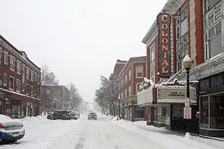
Laconia is a city in Belknap County, New Hampshire, United States. The population was 16,871 at the 2020 census, up from 15,951 at the 2010 census. It is the county seat of Belknap County. Laconia, situated between Lake Winnipesaukee and Lake Winnisquam, includes the villages of Lakeport and Weirs Beach. Each June, the city hosts Laconia Motorcycle Week, also more simply known as "Bike Week", one of the country's largest rallies.
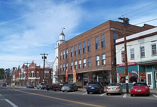
Tilton is a town on the Winnipesaukee River in Belknap County, New Hampshire, United States. The population was 3,962 at the 2020 census, up from 3,567 at the 2010 census. It includes the villages of Tilton and Lochmere and part of the village of Winnisquam. Tilton is home to the Tilton School, a private preparatory school.

Meredith is a town in Belknap County, New Hampshire, United States. The population was 6,662 at the 2020 census. Meredith is situated in the state's Lakes Region and serves as a major resort town. Meredith Village, the commercial center of the town, lies long the shores of Lake Winnipesaukee, and several other large lakes lie partially or completely within the town borders. It is home to the Stonedam Island Natural Area and the Winnipesaukee Scenic Railroad, and it serves as one of the ports of call for the MS Mount Washington.
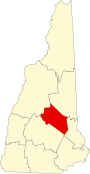
This is a list of the National Register of Historic Places listings in Belknap County, New Hampshire.

This is a list of properties and historic districts in Missouri on the National Register of Historic Places. There are NRHP listings in all of Missouri's 114 counties and the one independent city of St. Louis.
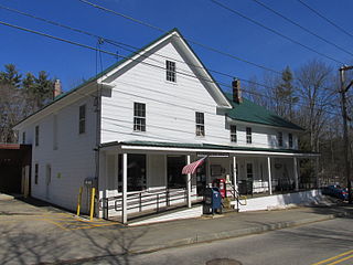
Lochmere is an unincorporated community in the towns of Tilton and Belmont in Belknap County, New Hampshire, in the United States. It is located along U.S. Route 3 and New Hampshire Route 11, which connect the village with Laconia to the northeast and to the center of Tilton and to Franklin to the southwest. It is close to the Winnipesaukee River as it connects the outlet of Lake Winnisquam to the north with Silver Lake to the south.
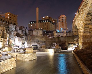
Mill Ruins Park is a park in downtown Minneapolis, Minnesota, United States, standing on the west side of Saint Anthony Falls on the Mississippi River and running from 3rd Ave. S. to about 9th Ave. S. The park interprets the history of flour milling in Minneapolis and shows the ruins of several flour mills that were abandoned.

The Shawnee Lookout Archeological District is a historic district in the southwestern corner of the U.S. state of Ohio. Located southwest of Cleves in Hamilton County's Miami Township, the district is composed of forty-six archaeological sites spread out over an area of 2,000 acres (810 ha). Thirty-four of these sites are located in the 1,000-acre (400 ha) Shawnee Lookout Park, which has been called one of the most beautiful parks in southwestern Ohio.

The Brooks River Archaeological District encompasses a large complex of archaeological sites along the banks of the Brooks River in Katmai National Park and Preserve in the U.S. state of Alaska. It includes at least twenty separate settlement sites with documented occupation dates from 2500 BCE to recent (post-contact) history. It was declared a National Historic Landmark in 1993. The site is partly occupied by the Brooks Camp, one of the major visitor areas of the park.

Cedar Swamp Archeological District is a prehistoric and historic archaeologically sensitive area in eastern Westborough, Massachusetts, and extending into the northwest corner of Hopkinton. Cedar Swamp is an area of more than 2,600 acres (1,100 ha) of wetlands that include the headwaters area of the Sudbury River. Archeological surveys of the environmentally sensitive and critical area have identified many Native American sites of interest. It is believed that Native Americans prized wood from the cedar trees that grew in the area. The archeological district, which encompasses much of the Cedar Swamp area, was added to the National Register of Historic Places in 1988.
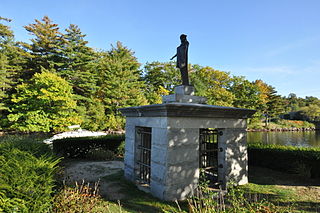
Endicott Rock is a state park located on the shore of Lake Winnipesaukee in the Weirs Beach village of Laconia, New Hampshire. Its principal attraction is a large rock originally in the lake that was incised with lettering in 1652 by surveyors for the Massachusetts Bay Colony. The rock provides definitive evidence of one of the earliest incursions of Europeans into the area.

The Franklin Falls Historic District is a 75-acre (30 ha) historic district encompassing most of the civic and industrial heart of Franklin, New Hampshire, which saw its most significant development in the second half of the 19th century and the first decades of the 20th. The district is focused on Central Street between two crossings of the Winnipesaukee River, and includes Odell Park along with industrial properties along the bend in the river north of those two crossings, as well as a number of properties on adjacent streets south of Central Street. The district was listed on the National Register of Historic Places in 1982.

The Bellows Falls Petroglyph Site is an archaeological site containing panels of precontact Native American petroglyphs in Bellows Falls, Vermont. Located near the Vilas Bridge on bedrock west of and above the Connecticut River, adjacent to Great Falls, they depict a rarely-seen assemblage of anthropomorphic figures that is believed to be unique in New England, and uncommon even in surrounding geographic areas. The site was listed on the National Register of Historic Places in 1990.

The Hunter Archeological Site is a significant prehistoric Native American site in Claremont, New Hampshire. Located near the bridge connecting Claremont and Ascutney, Vermont, the site includes seven levels of occupational evidence, including evidence of at least three longhouses. The oldest dates recorded from evidence gathered during excavations in 1967 were to AD 1300. The site was listed on the National Register of Historic Places in 1976.
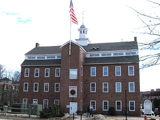
The Belknap-Sulloway Mill, now the Belknap Mill Museum, is a historic mill at 25 Beacon Street East in Laconia, New Hampshire, a city in Belknap County. Built sometime between 1823 and 1828, it is a rare well-preserved example of an early rural textile mill in New England, and was the business around which the city rose. The mill was in active use for the production of textiles until 1969, undergoing some modest alterations as well as the modernization of its power plant. It was opened as a museum in 1991, and was listed on the National Register of Historic Places in 1971.

The Busiel-Seeburg Mill is a historic mill building in Laconia, New Hampshire, since converted into an office building known as 1 Mill Plaza. This 3-1/2 story brick structure achieved its present configuration in stages, beginning in 1853, and successively altered and expanded through the rest of the 19th century. The business, established by John W. Busiel in 1846, manufactured knitted hosiery, and was one of the first producers of knitwear to use circular knitting machines invented by Aiken and Peppers. The building was listed on the National Register of Historic Places in 1971.

Aquadoctan was one of the largest known Native American villages in what is now the U.S. state of New Hampshire. In an area commonly known today as The Weirs, the village lay on the north bank of the Winnipesaukee River at the outlet of Lake Winnipesaukee in the Lakes Region of New Hampshire. The site is now in Weirs Beach, a summer resort and village of the city of Laconia. The Native American village, whose archaeological remains extend for a half mile along the river and a quarter mile along the lake, has been documented through archaeological investigation to have evidence of settlement from 9,000 BCE to the late seventeenth century. Colonial reports document that the site was abandoned substantially in 1696, when most of New Hampshire's remaining native population withdrew to join the Pequawket at present-day Fryeburg, Maine.

The Tilton Downtown Historic District encompasses a roughly one-block section of Main Street in the center of Tilton, New Hampshire. It extends from Central Street in the west to Bridge and School Streets in the east, including all of the buildings on the north side of this section, and a cluster of buildings on the south side near Bridge Street. The area has long been a commercial and industrial center for the town, although most of the buildings now date from the late 19th century onward, and include a fine array of Victorian architecture. The district was listed on the National Register of Historic Places in 1983.

The New Hampshire Veterans' Association Historic District encompasses a large cluster of late 19th-century summer resort properties in the Weirs Beach area of Laconia, New Hampshire, United States. The district is a nearly 8-acre (3.2 ha) area developed by the New Hampshire Veterans' Association, which was formed to support summer reunions of veterans of the American Civil War. Over the following decades the group expanded its range to encompass veterans from all of the United States' war efforts. The architecture of the resort area the association developed is distinctive, as the resort houses were built to accommodate entire regiments. The district includes 18 buildings, five of which front on Lakeside Avenue and have expansive views of Lake Winnipesaukee and the Weirs Beach area. Most of the remaining buildings are located on Veterans Avenue, which runs roughly parallel to, and behind, Lakeside Avenue. The district was listed on the National Register of Historic Places in 1980.
The Sebec-Piscataquis River Confluence Prehistoric Archeological District encompasses a collection of important prehistoric archaeological sites in Milo, Maine. Located near the mouth of the Sebec River where it meets the Piscataquis River, these sites include several deeply stratified sites covering 5,000 years of history dating back to 8,300 BCE. The area was listed on the National Register of Historic Places in 1986.