
Broward County is a county in the southeastern part of Florida, located in the Miami metropolitan area. It is Florida's second-most populous county after Miami-Dade County and the 17th-most populous in the United States, with 1,944,375 residents as of the 2020 census. Its county seat and largest city is Fort Lauderdale, which had a population of 182,760 as of 2020.

The Everglades is a natural region of flooded grasslands in the southern portion of the U.S. state of Florida, comprising the southern half of a large drainage basin within the Neotropical realm. The system begins near Orlando with the Kissimmee River, which discharges into the vast but shallow Lake Okeechobee. Water leaving the lake in the wet season forms a slow-moving river 60 miles (97 km) wide and over 100 miles (160 km) long, flowing southward across a limestone shelf to Florida Bay at the southern end of the state. The Everglades experiences a wide range of weather patterns, from frequent flooding in the wet season to drought in the dry season. Throughout the 20th century, the Everglades suffered significant loss of habitat and environmental degradation.

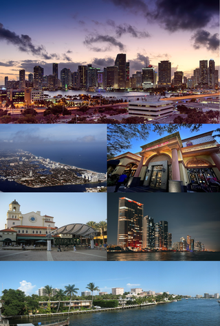
Fort Lauderdale is a coastal city located in the U.S. state of Florida, 30 miles (48 km) north of Miami along the Atlantic Ocean. It is the county seat of and largest city in Broward County with a population of 182,760 at the 2020 census, making it the tenth largest city in Florida. After Miami and Hialeah, Fort Lauderdale is the third largest city in the Miami metropolitan area, which had a population of 6,166,488 in 2019.

Plantation is a city in Broward County, Florida, United States. It is a part of the South Florida metropolitan area. The city's name comes from the previous part-owner of the land, the Everglades Plantation Company, and their unsuccessful attempts to establish a rice plantation in the area. As of the 2020 U.S. census, the population was 91,750.

The Caloosahatchee River is a river on the southwest Gulf Coast of Florida in the United States, approximately 67 miles (108 km) long. It drains rural areas on the northern edge of the Everglades, east of Fort Myers. An important link in the Okeechobee Waterway, a manmade inland waterway system of southern Florida, the river forms a tidal estuary along most of its course and has become the subject of efforts to restore and preserve the Everglades.
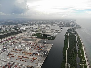
Port Everglades is a seaport in Fort Lauderdale, Florida, located in Broward County. Port Everglades is one of South Florida's foremost economic engines, as it is the gateway for both international trade and cruise vacations. In 2022, Port Everglades was ranked the third-busiest cruise homeport, accommodating more than 1.72 million passengers. Port Everglades' cargo sector has been climbed up the rankings based on its operational performance among 348 seaports in the world.
The Miami metropolitan area, also known as South Florida, SoFlo, SoFla, the Gold Coast, the Tri-County Area, or Greater Miami, and officially known as the Miami–Fort Lauderdale–West Palm Beach Metropolitan Statistical Area, is a coastal metropolitan area in southeastern Florida. It is the ninth-largest metropolitan statistical area (MSA) in the United States, the fifth-largest metropolitan area in the Southern United States, and the largest metropolitan area in Florida. With a population of 6.14 million, its population exceeds 31 of the nation's 50 states as of 2022. It comprises the three most populated counties in the state, Miami-Dade County, Broward County, and Palm Beach County, which rank as the first, second, and third-most populous counties in the state, respectively. Miami-Dade County, with 2,716,940 people in 2019, is the seventh-most populous county in the United States.
The Okeechobee Waterway or Okeechobee Canal is a relatively shallow artificial waterway in the United States, stretching across Florida from Fort Myers on the west coast to Stuart on Florida's east coast. The waterway can support tows such as barges or private vessels up to 50 feet wide x 250 feet long which draw less than 10 feet, as parts of the system, especially the locks may have low water depths of just ten feet. The system of channels runs through Lake Okeechobee and consists of the Caloosahatchee River to the west of the lake and the St. Lucie Canal east of the lake.

The Hillsboro Canal is located in the southeastern portion of Florida within the South Florida Water Management District, and for much of its length forms the border between Broward and Palm Beach counties; however, its western end was entirely in Palm Beach County, until being recently annexed to Broward County-Parkland, FL. It begins at Lake Okeechobee at the S-2 water control structure in South Bay west of Belle Glade, Florida. It passes within the southern border of the Loxahatchee National Wildlife Refuge and flows southeast from there along Loxahatchee Road in a rural, lightly populated area. When it reaches the more heavily built-up region further east, it bends to head due eastward, forming the county line. Near its eastern end at the Intracoastal Waterway, with Boca Raton to the north and Deerfield Beach to the south, it departs from its straight course to go around several curves, but the county boundary continues to follow it at this point. 10 miles of the canal is navigable, and it is popular for recreational boating and fishing.
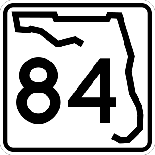
State Road 84 is a highway in the U.S. state of Florida originally extending from the Tamiami Trail in Naples to Federal Highway in Fort Lauderdale. The road now consists of two noncontiguous pieces––in Collier County as Davis Boulevard and in Broward County as Marina Mile Boulevard and highway frontage roads.
Robert (Bob) S. Carr is an American archaeologist and the current executive director of The Archaeological and Historical Conservancy, Inc. He specializes in Southeastern archaeology, with particular emphasis on archaeology in Florida. He has also conducted fieldwork in the Bahamas.
The history of Fort Lauderdale, Florida began more than 4,000 years ago with the arrival of the first aboriginal natives, and later with the Tequesta Indians, who inhabited the area for more than a thousand years. Though control of the area changed among Spain, England, the United States, and the Confederate States of America, it remained largely undeveloped until the 20th century. The first settlement in the area was the site of a massacre at the beginning of the Second Seminole War, an event which precipitated the abandonment of the settlement and set back development in the area by over 50 years. The first United States stockade named Fort Lauderdale was built in 1838, and subsequently was a site of fighting during the Second Seminole War. The fort was abandoned in 1842, after the end of the war, and the area remained virtually unpopulated until the 1890s.

A national push for expansion and progress toward the latter part of the 19th century stimulated interest in draining the Everglades, a region of tropical wetlands in southern Florida, for agricultural use. According to historians, "From the middle of the nineteenth century to the middle of the twentieth century, the United States went through a period in which wetland removal was not questioned. Indeed, it was considered the proper thing to do."
The following is an alphabetical list of articles related to the U.S. state of Florida.

The New River is a tidal estuary in South Florida, United States. Despite its name, it is not a river, but a channel composed of many tributary canals, The channel is connected to the Everglades through a series of man-made canals. After passing through Fort Lauderdale, the channel connects to the Intracoastal Waterway and Atlantic Ocean at Port Everglades cut. The channel is entirely within Broward County and is composed from the junction of three main canals which originate in the Everglades, splitting off from the Miami Canal. They are the North New River Canal, which flows south from Lake Okeechobee along the east side of U.S. 27 and then east along the north side of State Road 84 / Interstate 595; the South New River Canal, which flows east from the Miami Canal along the north side of Griffin Road and the south side of Orange Drive; and a canal which flows east along the south side of Sunrise Boulevard.
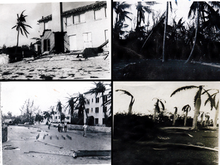
The 1947 Fort Lauderdale hurricane had widespread impacts in Florida. It produced significant flooding, damage to vegetation, and beach erosion in the Miami metropolitan area. After forming off West Africa on September 2, the storm moved on a parabolic path that brought it through The Bahamas as a Category 3 hurricane on September 16, eventually striking the city of Fort Lauderdale in South Florida as a powerful Category 4 hurricane on the following day. The hurricane later crossed the state, entered the Gulf of Mexico near Naples less than 24 hours later, and went on to strike Louisiana before dissipating on September 21.
Okeelanta is an unincorporated community in Palm Beach County, Florida, United States, located approximately 4 miles (7 km) south of South Bay on U.S. Route 27 at County Road 827. It was originally developed as a planned community in the 1910s, but had effectively disappeared by the end of the 1920s. The name is a portmanteau of Lake Okeechobee and Atlantic Ocean.

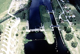
The St. Lucie Canal, also known as the C-44 Canal or simply C-44, is a man-made canal in Martin County, Florida, connecting Lake Okeechobee to the Indian River Lagoon. The canal was built between 1916 and 1924 to divert floodwaters from the lake into the St. Lucie Estuary via the South Fork of the St. Lucie River. Deepened in 1937 to enable the passage of boats, the St. Lucie Canal is now the eastern segment of the Okeechobee Waterway.
The following is a timeline of the history of the city of Fort Lauderdale, Florida, USA.


