Brasenose College (BNC) is one of the constituent colleges of the University of Oxford in the United Kingdom. It began as Brasenose Hall in the 13th century, before being founded as a college in 1509. The library and chapel were added in the mid-17th century and the new quadrangle in the late 19th and early 20th centuries.

Hertford College, previously known as Magdalen Hall, is a constituent college of the University of Oxford in England. It is located on Catte Street in the centre of Oxford, directly opposite the main gate to the Bodleian Library. The college is known for its iconic bridge, the Bridge of Sighs. There are around 600 students at the college at any one time, comprising undergraduates, graduates and visiting students from overseas.

Lincoln College is one of the constituent colleges of the University of Oxford, situated on Turl Street in central Oxford. Lincoln was founded in 1427 by Richard Fleming, the then Bishop of Lincoln.

New College is one of the constituent colleges of the University of Oxford in the United Kingdom. Founded in 1379 by William of Wykeham in conjunction with Winchester College as its feeder school, New College was one of the first colleges in the university to admit and tutor undergraduate students.
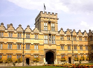
University College, formally The College of the Great Hall of the University of Oxford and colloquially referred to as "Univ", is a constituent college of the University of Oxford in England. It has a claim to being the oldest college of the university, having been founded in 1249 by William of Durham.

Bedlington is a town and former civil parish in Northumberland, England, with a population of 18,470 measured at the 2011 Census.

Arthur Lehman Goodhart was an American-born academic jurist and lawyer; he was Professor of Jurisprudence at the University of Oxford, 1931–51, when he was also a Fellow of University College, Oxford. He was the first American to be the Master of an Oxford college, and was a significant benefactor to the college.
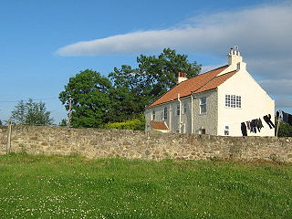
Archdeacon Newton is a hamlet and rural parish of several farms in the borough of Darlington and the ceremonial county of County Durham, in England. The population taken at the 2011 Census was less than 100. Details are maintained in the parish of Walworth. It is associated with an abandoned village site under pasture and farm buildings, and situated a short distance to the north-west of Darlington. The lost settlement was in existence by the early 15th century, and remained inhabited at least until the 1890s. There was a moated manor house at the southern end, part of which remains as the Old Hall, now a barn. At the north end of the site was the chapel, and in the middle were tofts and enclosures, with a ridge and furrow field and a trackway leading to the south-east. The site of the abandoned village is now a scheduled monument and the Old Hall is a listed building.

Radcliffe is a market town in the Metropolitan Borough of Bury, Greater Manchester, England. It lies in the Irwell Valley 7 miles (11 km) northwest of Manchester and 3 miles (5 km) southwest of Bury and is contiguous with Whitefield to the south. The disused Manchester Bolton & Bury Canal bisects the town.

The Bailey is a historic street in the centre of the city of Durham, in County Durham, England. It is on a peninsula within a sharp meander in the River Wear, formed by isostatic adjustment of the land. The name The Bailey derives from the outer bailey of the Norman motte and bailey-style Durham Castle. Vehicular access to the area is restricted by the Durham City congestion charge, which started in 2002 and is the UK's oldest such scheme.

The Radcliffe Quadrangle is the second quadrangle of University College, Oxford, England. The buildings have been Grade I listed since 1954.

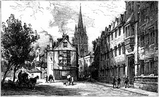
The High Street in Oxford, England, known locally as the High, runs between Carfax, generally seen as the centre of the city, and Magdalen Bridge to the east.

Merton Street is a cobbled street in central Oxford, England. It joins the High Street at its northeastern end, between the Ruskin School of Drawing and Fine Art and the Eastgate Hotel at the historic east gate of the city. It then runs east–west, parallel and to the south of the High Street for most of its length.
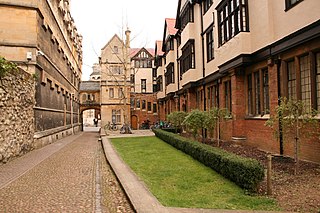
The Logic Lane covered bridge is a small covered bridge at the High Street end of Logic Lane, within University College, Oxford, England.
Oriel Street is a narrow but historic street running between the High Street to the north and Oriel Square to the south in central Oxford, England. The street is now blocked off to traffic by bollards at the High Street end.

Magpie Lane is a narrow historic lane in central Oxford, England. It leads south from the High Street where it is at its narrowest, now completely pedestrianised as a pavement, and north from the cobbled Merton Street.

Market Street is a street in central Oxford, England, running east to west.
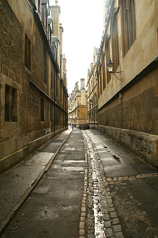
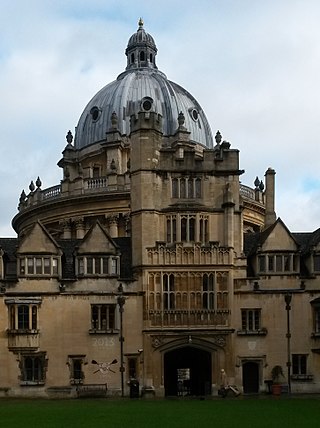
Brasenose Lane runs east–west in central Oxford, England, between Turl Street and Radcliffe Square respectively. From Turl Street it is only accessible to pedestrians, but vehicles can enter from Radcliffe Square. The lane retains the medieval pattern of a single drainage channel in its centre and has high stone-faced college buildings on each side, being flanked by three historic Oxford colleges.

The octagonal Chapel of St Mary at Smith Gate is a former chapel in Oxford, England, now part of Hertford College. It is located on Catte Street, opposite the Clarendon Building.


