London District, Upper Canada

Last updated
London District
Former District in Upper Canada
A map of the province of Upper Canada describing all the settlements and townships, 1818.jpg
Map of Upper Canada Identifying its districts, counties and townships (1818)
Established1798
Dissolved1849

The London District was a historic district in Upper Canada. It was formed in 1798 from parts of the Home and Western Districts, and lasted until its abolition in 1850.

Contents

Historic evolution

The District was formed by an Act of the Parliament of Upper Canada in 1798, and was described as consisting of

...the Counties of Norfolk, Oxford and Middlesex with so much of this Province as lies to the Westward of the Home District, and the District of Niagara, to the Southward of Lake Huron, and between them and a line drawn due north of a fixed boundary (where the easternmost limit of the township of Oxford intersects the River Thames till it arrives at Lake Huron... [1]

The townships and counties were thus organized:

Counties of the London District (1798) [2]
Norfolk CountyOxford CountyMiddlesex County
  • Rainham
  • Walpole
  • Woodhouse
  • Charlotteville
  • Walsingham
  • Houghton
  • Middleton
  • Windham
  • Townsend
  • Burford
  • Norwich
  • Dereham
  • Oxford upon the Thames
  • Blandford
  • Blenheim
  • London
  • Westminster
  • Dorchester
  • Yarmouth
  • Southwold
  • Dunwich
  • Aldborough
  • Delaware

The district town was Charlotteville (later named Turkey Point), but moved to Tisdale's Mills (later named Vittoria) in 1815. [3] [4] In 1826, the district town was moved to London, and the townships of Rainham and Walpole were moved to Haldimand County in Niagara District because of their distance from London. [5]

The Huron Tract, being developed at the time by the Canada Company, was divided between the London and Western Districts in 1835, with the greater part of the territory in the London District forming the new Huron County. [6] That County was later withdrawn in October 1841 to form the new Huron District. [7]

In 1837, Oxford County was separated into the new Brock District, [8] and Norfolk County was separated to form Talbot District. [9]

In 1840, the following lands were withdrawn from London District and attached to Waterloo County in Wellington District: [10] [11]

  • reserved lands west of Woolwich and Nichol [12]
  • the triangular piece of land adjoining the said tract in the proposed District of Huron [13]
  • part of the late purchase from the Indians of Gore, [14] and part of Indian lands [15] [16]

In 1845, the District was restricted in area to cover Middlesex County only. [17] thus detaching the remainder of its northern part extending to Lake Huron. This was rectified by the territory's attachment to Huron District in 1846. [18]

At the beginning of 1850, the district was abolished, being replaced by the United Counties of Middlesex and Elgin and in 1850 as standalone Middlesex County for municipal purposes. [19]

Further reading

Related Research Articles

<span class="mw-page-title-main">Middlesex County, Ontario</span> County in Ontario, Canada

Middlesex County is a primarily rural county in Southwestern Ontario, Canada. Landlocked, the county is bordered by Huron and Perth counties on the north, Oxford County on the east, Elgin County on the south, and Chatham-Kent and Lambton County on the west.

<span class="mw-page-title-main">Haldimand County</span> City in Ontario, Canada

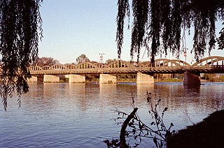
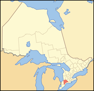
Haldimand County is a rural city-status single-tier municipality on the Niagara Peninsula in Southern Ontario, Canada, on the north shore of Lake Erie, and on the Grand River. Despite its name, it is no longer a county by definition, as all municipal services are handled by a single level of government. Municipal offices are located in Cayuga.

<span class="mw-page-title-main">Hastings County</span> County in Ontario, Canada

Hastings County is located in the province of Ontario, Canada. Geographically, it is located on the border of Eastern Ontario and Central Ontario. Hastings County is the second-largest county in Ontario, after Renfrew County, and its county seat is Belleville, which is independent of Hastings County. Hastings County has trademarked the moniker "Cheese Capital of Canada".

<span class="mw-page-title-main">Norfolk County, Ontario</span> City in Ontario, Canada

Norfolk County is a rural single-tier municipality on the north shore of Lake Erie in Southwestern Ontario, Canada with a 2016 population of 67,490. Despite its name, it is no longer a county by definition, as all municipal services are handled by a single level of government. The largest community in Norfolk County is Simcoe, whose 2016 population was 13,922. The other population centres are Port Dover, Delhi, Waterford and Port Rowan, and there are many smaller communities. For several years in the late 20th century, the county was merged with Haldimand County but the merged entity was dissolved in 2000.

<span class="mw-page-title-main">Simcoe County</span> County in Ontario, Canada

Simcoe County is located in the central portion of Southern Ontario, Canada. The county is just north of the Greater Toronto Area, stretching from the shores of Lake Simcoe in the east to Georgian Bay in the west. Simcoe County forms part of the Greater Golden Horseshoe area, a densely populated and industrialized region, centred on the Greater Toronto Area.

<span class="mw-page-title-main">Huron County, Ontario</span> County in Ontario, Canada

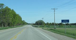
Huron County is a county of the province of Ontario, Canada. It is located on the southeast shore of its namesake, Lake Huron, in the southwest part of the province. The county seat is Goderich, also the county's largest community.

<span class="mw-page-title-main">Grey County</span> County in Ontario, Canada

Grey County is a county of the Canadian province of Ontario. The county seat is in Owen Sound. It is located in the subregion of Southern Ontario named Southwestern Ontario. Grey County is also a part of the Georgian Triangle. At the time of the Canada 2016 Census the population of the county was 93,830.

<span class="mw-page-title-main">Lennox and Addington County</span> County in Ontario, Canada

Lennox and Addington County is a county and census division of the Canadian province of Ontario. The county seat is Greater Napanee. It is located in the subregion of Southern Ontario named Eastern Ontario.

Lennox County is a historic county in the Canadian province of Ontario which now forms part of Lennox and Addington County. It was named after Charles Lennox, 3rd Duke of Richmond.

<span class="mw-page-title-main">Home District</span> Former District in Upper Canada

The Home District was one of four districts of the Province of Quebec created in 1788 in the western reaches of the Montreal District and detached in 1791 to create the new colony of Upper Canada. It was abolished with the adoption of the county system in 1849.

<span class="mw-page-title-main">Western District, Upper Canada</span> Former District in Upper Canada

Western District was one of four districts of the Province of Quebec created in 1788 in the western reaches of the Montreal District which were later detached in 1791 to create the new colony of Upper Canada. Known as Hesse District until 1792, it was abolished in 1849.

<span class="mw-page-title-main">Eastern District, Upper Canada</span>

Eastern District was one of four districts of the Province of Quebec created in 1788 in the western reaches of the Montreal District and partitioned in 1791 to create the new colony of Upper Canada.

<span class="mw-page-title-main">Midland District, Upper Canada</span>

Midland District was one of four districts of the Province of Quebec created in 1788 in the western reaches of the Montreal District and partitioned in 1791 to create the new colony of Upper Canada.

<span class="mw-page-title-main">Johnstown District, Upper Canada</span>

The Johnstown District was a historic district in Upper Canada which existed until 1849.

<span class="mw-page-title-main">Newcastle District</span>

The Newcastle District was a historic district in Upper Canada which existed until 1849. It was formed in 1802 from the Home District, consisting of the counties of Durham and Northumberland.

<span class="mw-page-title-main">Niagara District</span> Former District in Upper Canada

The Niagara District was a historic district in Upper Canada. Created in 1798 from the Home District, it existed until 1849.

<span class="mw-page-title-main">Wellington District, Upper Canada</span> Former district of Upper Canada

The Wellington District was a historic district in Upper Canada and its successor, Canada West, which existed until 1849. It was formed in June 1840 from townships transferred from certain other districts:

<span class="mw-page-title-main">Bathurst District</span>

The Bathurst District was a historic district in Upper Canada. It was created in 1822 from the Johnstown District. Containing Carleton County, it existed until 1849. The district town was Perth.

Haldimand was an electoral district of the Legislative Assembly of the Parliament of the Province of Canada, in Canada West. It was based on Haldimand County. The electoral district was created in 1841, upon the establishment of the Province of Canada by the union of Upper Canada and Lower Canada. Haldimand was represented by one member in the Legislative Assembly. It was abolished in 1867, upon the creation of Canada and the province of Ontario.

Huron was an electoral district of the Legislative Assembly of the Parliament of the Province of Canada, in Canada West. It was created in 1841, upon the establishment of the Province of Canada by the union of Upper Canada and Lower Canada, and was based on Huron County. Huron was represented by one member in the Legislative Assembly. It was abolished in 1867, upon the creation of Canada and the province of Ontario.

References

  1. An act for the better division of this province , S.U.C. 1798, c. 5, s. 37
  2. 1798 Act, ss. 33, 35, 36
  3. "The District Capital 1815-1825". ontarioplaques.com. Retrieved January 13, 2018.
  4. An Act to repeal part of, and to amend an Act of the Parliament of this Province, intituled, "An Act to remove doubt with respect to the authority under which the Courts of General Quarter Sessions of the Peace, and other Courts have been erected and holden, and other matters with respect to the Administration of Justice, done in the several Districts of this Province, and also to fix the time of holding the Courts of General Quarter Sessions of the Peace in and for the same," and to make further provision for the same , S.U.C. 1815, c. 16
  5. An Act to establish the District Town of the District of London to a more central position than at present, and to annex the Townships of Walpole and Rainham to the County of Haldimand, in the District of Niagara , S.U.C. 1826, c. 13
  6. An Act to form certain Townships in the London District into a County, and to attach certain Townships to the Counties of Middlesex and Kent, in the London and Western Districts , S.U.C. 1835, c. 46
  7. An Act to authorize the erection of the County of Huron, and certain other territory adjacent thereto, into a separate District , S.U.C. 1838, c. 26 , brought into effect by "Proclamation". Canada Gazette . 1 (3 (Extra)): 30. October 21, 1841.
  8. An Act to authorise the erection of the County of Oxford into a separate District, by the name of the District of Brock , S.U.C. 1837, c. 30
  9. An Act erecting the County of Norfolk into a separate District, by the name of the District of Talbot , S.U.C. 1837, c. 33
  10. An Act erecting certain parts of the Counties of Halton and Simcoe into a new District, by the name of the District of Wellington , S.U.C. 1837 (1st Session), c. 116 , implemented by Proclamation of June 18, 1840
  11. Armstrong, Frederick H. (1985). Handbook of Upper Canadian Chronology. Toronto: Dundurn Press. p. 195. ISBN   0-919670-92-X. Archived from the original on 2017-09-19. Retrieved 2018-01-16.
  12. later surveyed to form the townships of Wellesley and Peel
  13. later surveyed to form the townships of Maryborough and Wallace
  14. being the Mississaugas
  15. acquired under the Saugeen Tract Agreement
  16. the sum of which was surveyed into townships on either side of the Garafraxa Road that was constructed in the period 1840-1848 to the new community of Sydenham
  17. An Act for better defining the limits of the Counties and Districts in Upper Canada, for erecting certain new Townships, for detaching Townships from some Counties and attaching them to others, and for other purposes relative to the division of Upper Canada into Townships, Counties and Districts , S.C. 1845, c. 7, s. 8
  18. An Act to attach certain Territory therein described to the District of Huron for certain purposes , S.Prov.C. 1846, c. 47
  19. An Act for abolishing the Territorial Division of Upper-Canada into Districts, and for providing temporary Unions of Counties for Judicial and other purposes, and for the future dissolutions of such Unions, as the increase of wealth and population may require , S.Prov.C. 1849, c. 78, Sch. C

43°24′N81°12′W / 43.4°N 81.2°W / 43.4; -81.2