
North Rocks is a suburb straddling the Hills District and the North Shore of Parramatta within Greater Western Sydney, in the state of New South Wales, Australia, located 26 kilometres north-west of the Sydney central business district. Following the amalgamation of council areas in 2016, the majority of North Rocks falls into the council area of the City of Parramatta. Streets north of the M2 Hills Motorway are within The Hills Shire.
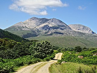
Beinn Eighe is a mountain massif in the Torridon area of Wester Ross in the Northwest Highlands of Scotland. Lying south of Loch Maree, it forms a long ridge with many spurs and summits, two of which are classified as Munros: Ruadh-stac Mòr at 1,010 m (3,314 ft) and Spidean Coire nan Clach at 993 m (3,258 ft). Unlike most other hills in the area it has a cap of Cambrian basal quartzite which gives the peaks of Beinn Eighe a distinctive light colour. Its complex topography has made it popular with both hillwalkers and climbers and the national nature reserve on its northern side makes it an accessible mountain for all visitors.
The area referred to as Fourways is the fastest-developing commercial and residential hub in Sandton, north of Johannesburg, South Africa. The main access routes to Fourways are off the N1 at R511 Winnie Mandela Drive, or alternatively along R564 Witkoppen Road. It is located mostly in Region E of the City of Johannesburg Metropolitan Municipality. It is roughly as far as one can go in the Johannesburg Metropolitan area before it dissolves into rolling hills, game farms and the capital Pretoria, 55 kilometres to the northeast. Hartebeespoort Dam and the Magaliesberg Mountains lie half an hour to the north-west. It is bordered by Bryanston to the east and south and Randburg to the west.

Radnor Forest is a rock dome composed of Silurian shales, mudstones and limestone in the historic county of Radnorshire, Powys, Mid Wales. It is a forest in the medieval sense of the word. It lies within the Welsh Marches region since Offa's Dyke lies nearby to the east.
Lone Hill is a suburb north of Johannesburg, South Africa. It is located in Region E. Lone Hill is in the Gauteng province and is a suburb in Sandton.
Kensington is a hilly suburb of Johannesburg, South Africa. It was established in 1897 by Max Langermann. It is located in Region F of the City of Johannesburg Metropolitan Municipality and is bounded to the west by the suburb of Troyeville, to the east by Bedfordview and the north by Bruma and Cyrildene.

Kellyville is a suburb of Sydney, in the state of New South Wales, Australia 36 kilometres north-west of the Sydney central business district in the local government area of The Hills Shire. It is part of the Hills District region.
Emmarentia is a suburb of Johannesburg, South Africa.

Rocking stones are large stones that are so finely balanced that the application of just a small force causes them to rock. Typically, rocking stones are residual corestones formed initially by spheroidal weathering and have later been exposed by erosion or glacial erratics left by retreating glaciers. Natural rocking stones are found throughout the world. A few rocking stones might be man-made megaliths.
There are many large stones of Scotland of cultural and historical interest, such as the distinctive Pictish stones.

Springbok is the largest town in the Namaqualand area in the Northern Cape province of South Africa. It was called Springbokfontein until 1911, when it was shortened to Springbok. Springbok is located on the N7 national route which connects the Cape with Namibia, and at the western end of the N14, which connects it with Upington and Pretoria. It is the main town of the Nama Khoi Local Municipality, which also includes a number of surrounding towns such as Okiep and Nababeep.

Maol Cheann-Dearg is a mountain in the Northwest Highlands of Scotland, between Upper Loch Torridon and Loch Carron, in the Coulags deer forest in Wester Ross. It is one of three Munros in this area and reaches a height of 933 metres (3,060 feet), it is slightly isolated from the other two being separated by a low col of 420 metres and therefore tends to be ascended separately. The mountain is typical of the region in that geologically it is made up of a mixture of sandstone and quartzite, it has a steep flanks and is rock-strewn. The dome shaped summit is littered with red sandstone boulders and lacking in vegetation making its translated name of "red-headed brow" especially appropriate. The mountain is not to be confused with Maol Chinn-dearg, another Munro on the south Glen Shiel ridge.

Wharncliffe Crags is a gritstone escarpment or edge situated approximately 6 miles (10 km) north-west of the city of Sheffield in South Yorkshire, England. It is a geological Site of Special Scientific Interest.

Melville Koppies is a nature reserve and a Johannesburg City Heritage Site in Johannesburg, South Africa. The word 'koppie' means small hill.

The Tuli Block is a narrow fringe of land at Botswana's eastern border wedged between Zimbabwe in the north and east and South Africa in the south. It consists mainly of privately owned game farms offering safari tourism. The eastern section up to and including Redshield has been declared a game reserve, known as the Northern Tuli Game Reserve.

A balancing rock, also called a balanced rock or precarious boulder, is a naturally occurring geological formation featuring a large rock or boulder, sometimes of substantial size, resting on other rocks, bedrock, or on glacial till. Some formations known by this name only appear to be balancing, but are in fact firmly connected to a base rock by a pedestal or stem.

Klipriviersberg Nature Reserve is a nature reserve consisting of veld and koppies (hills) run by the Johannesburg City Parks. It is located 11 kilometres (6.8 mi) south of Johannesburg, in an area of 640 hectares. Home to many species of flora and bird life, it is also home to large and small mammals such as blesbok, zebra, wildebeest and duiker.

Westdene is a suburb of Johannesburg, South Africa. Westdene lies between the historic suburb of Sophiatown and Melville with the Melville Koppies nature reserve to the north of the suburb. Westdene derives its name from its location, literally meaning west-valley. 'West' since it is located west from the city centre and with 'dene' derived from the Old English denu, meaning valley.

North Woods and North Meadow are two interconnected features in the northern section of Central Park, New York City, close to the neighborhoods of the Upper West Side and Harlem in Manhattan. The 90-acre (36 ha) North Woods, in the northwestern corner of the park, is a rugged woodland that contains a forest called the Ravine, as well as two water features called the Loch and the Pool. The western portion of the North Woods also includes Great Hill, the third highest point in Central Park. North Meadow, a recreation center and sports complex, is immediately southeast of the North Woods. Completed in the 1860s, North Woods and North Meadow were among the last parts of Central Park to be built.