
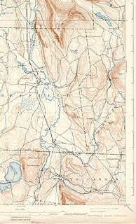
The Housatonic River is a river, approximately 149 miles (240 km) long, in western Massachusetts and western Connecticut in the United States. It flows south to southeast, and drains about 1,950 square miles (5,100 km2) of southwestern Connecticut into Long Island Sound. Its watershed is just to the west of the watershed of the lower Connecticut River.

Mount Frissell, 2,454 feet (748 m), which straddles the border of southwest Massachusetts and northwest Connecticut, is a prominent peak of the Taconic Range.

The Still River is a 25.4-mile-long (40.9 km) tributary to the Housatonic River in western Connecticut.
The Konkapot River is a 22.1-mile-long (35.6 km) river in southwestern Massachusetts and northern Connecticut. It is a tributary of the Housatonic River, not to be confused with the smaller Konkapot Brook in Stockbridge.
The village of Devon is a neighborhood of the city of Milford, Connecticut, United States. It lies on the southwest corner of the city bordering Long Island Sound and the mouth of the Housatonic River. The village generally corresponds to the Third Voting District of Milford.
The Rocky River is very short and small tributary of the Housatonic River in the U.S. state of Connecticut. It flows into the Housatonic River from the west just upstream from New Milford at 41°35′00″N73°26′23″W

The Washington Bridge, also known as the Devon Bridge, carries U.S. Route 1 (US 1) over the Housatonic River in the U.S. state of Connecticut, connecting the city of Milford to the town of Stratford. Its geographic location is N 41.20037 by W −73.11039. It is considered architecturally notable by the National Register of Historic Places for its five 100-foot-long (30 m) arches. It is designated Bridge No. 327 by the state Department of Transportation.

The Stevenson Dam Bridge carries Connecticut Route 34 over the Housatonic River in the U.S. state of Connecticut, connecting the town of Monroe to the town of Oxford.

The Pequonnock River is a 16.7-mile-long (26.9 km) waterway in eastern Fairfield County, Connecticut. Its watershed is located in five communities, with the majority of it located within Monroe, Trumbull, and Bridgeport. The river has a penchant for flooding, particularly in spring since the removal of a retention dam in Trumbull in the 1950s. There seems to be a sharp difference of opinion among historians as to just what the Indian word Pequonnock signifies. Some insist it meant cleared field or open ground; others are sure it meant broken ground; while a third group is certain it meant place of slaughter or place of destruction.
The Lillinonah Trail is a 5.9-mile (9.5 km) Blue-Blazed hiking trail "system" in the lower Housatonic River valley in Fairfield County and, today, is entirely in Newtown. Most of the trail is in the upper block of Paugussett State Forest.
Carting Island is the largest of the four islands owned by Stratford, Connecticut in the Housatonic River between I-95 and the Merritt Parkway. The island is north of the Moses Wheeler Bridge, east of Peacock Island (Connecticut), and southwest of Long Island (Connecticut), and Pope's Flat, it is also south of Fowler Island in Milford and the Igor I. Sikorsky Memorial Bridge. The island is uninhabited except for occasional visits by anglers, bird watchers and duck hunters. All transportation to and from the island is by boat.
Pope's Flat is the second largest of the four islands owned by Stratford, Connecticut in the Housatonic River between I-95 and the Merritt Parkway. The island is north of the Moses Wheeler Bridge, northeast of Carting Island, Long Island (Connecticut) and Peacock Island (Connecticut), and south of Fowler Island in Milford and the Igor I. Sikorsky Memorial Bridge. The island is uninhabited except for occasional visits by anglers, bird watchers and duck hunters.
Peacock Island is the smallest of the four islands owned by Stratford, Connecticut in the Housatonic River between I-95 and the Merritt Parkway. The island is north of the Moses Wheeler Bridge, west of Carting Island, southwest of Long Island (Connecticut), Pope's Flat, and south of Fowler Island in Milford and the Igor I. Sikorsky Memorial Bridge. The island is uninhabited except for occasional visits by anglers, bird watchers and duck hunters.
Fowler Island is the sole island owned by Milford, Connecticut north of I-95 in the Housatonic River. The island is north of the Moses Wheeler Bridge, and south of the Igor I. Sikorsky Memorial Bridge. The island is uninhabited except for occasional visits by anglers, bird watchers and duck hunters; all transportation to the island is by boat.
Goose Island is an island owned by Stratford, Connecticut below I-95 in the Housatonic River. The island is currently a set of three islets due to erosion running north–south near the Stratford bank of the river. The island is south-southwest of the Washington Bridge, roughly parallel to Housatonic Avenue.
Duck Island is the one of two islands in the Charles E. Wheeler Wildlife Management Area at the mouth of the Housatonic River. It is approximately 100 feet (30 m) from the end of Milford Point Road, near the Connecticut Audubon Society Coastal Center at Milford Point. The island is uninhabited and is designated as a Department of Environmental Protection Natural Area Preserve, though people may visit the island outside of bird nesting season. The maximum elevation on the island is ~16 feet (4.9 m).
Nells Island is the larger of two islands in the Charles E. Wheeler Wildlife Management Area at the mouth of the Housatonic River. It is directly across the river from the American Shakespeare Theatre in Stratford, Connecticut. The island is uninhabited but is designated as a "miscellaneous open space" by the City of Milford. It is about 3 feet (0.91 m) above sea level.
Wooster Island is an island in the Housatonic River in Orange, Connecticut
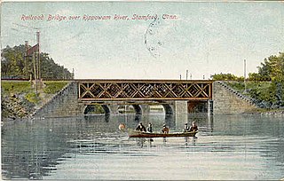
The Rippowam River is a river in Fairfield County, Connecticut, United States. It drains a watershed area of 37.5 square miles (97 km2) and flows for 17 miles (27 km) from Ridgefield to Long Island Sound, which it enters in Stamford's harbor.
Putney is a section in the north end of Stratford, Connecticut. The area includes Boothe Memorial Park and Museum and Putney Chapel and abuts the neighborhood of Oronoque. The area roughly includes all property from Chapel Street and Harry B. Flood Middle School across Connecticut Route 110 and the park to the River Road and Housatonic River.