Dorset is a ceremonial county in South West England. It is bordered by Somerset to the north-west, Wiltshire to the north and the north-east, Hampshire to the east, the Isle of Wight across the Solent to the south-east, the English Channel to the south, and Devon to the west. The largest settlement is Bournemouth, and the county town is Dorchester.

Corfe Castle is a village and civil parish in the English county of Dorset. It is the site of a ruined castle of the same name. The village and castle stand over a gap in the Purbeck Hills on the route between Wareham and Swanage. The village lies in the gap below the castle and is around four miles (6.4 km) south-east of Wareham, and four miles (6.4 km) north-northwest of Swanage. Both the main A351 road from Lytchett Minster to Swanage and the Swanage Railway thread their way through the gap and the village.

Christchurch is a town and civil parish on the south coast of Dorset, England. The parish had a population of 31,372 in 2021. It adjoins Bournemouth to the west, with the New Forest to the east. Part of the historic county of Hampshire, Christchurch was a borough within the administrative county of Dorset from 1974 until 2019, when it became part of the new Bournemouth, Christchurch and Poole unitary authority.

Poole is a coastal town and seaport on the south coast of England in the Bournemouth, Christchurch and Poole unitary authority area in Dorset, England. The town is 21 miles (34 km) east of Dorchester and adjoins Bournemouth to the east. Since 1 April 2019, the local authority is Bournemouth, Christchurch and Poole Council. The town had an estimated population of 151,500 making it the second-largest town in the ceremonial county of Dorset. Together with Bournemouth and Christchurch, the conurbation has a total population of nearly 400,000.

Brownsea Island is the largest of the islands in Poole Harbour in the county of Dorset, England. The island is owned by the National Trust with the northern half managed by the Dorset Wildlife Trust. Much of the island is open to the public and includes areas of woodland and heath with a wide variety of wildlife, together with cliff top views across Poole Harbour and the Isle of Purbeck.

Studland is a village and civil parish on the Isle of Purbeck in Dorset, England. The village is located about 2 miles (3.2 km) north of the town of Swanage, over a steep chalk ridge, and 3 miles (4.8 km) south of the South East Dorset conurbation at Sandbanks, from which it is separated by Poole Harbour. The parish includes Brownsea Island within the harbour. In the 2011 census the parish had 182 households and a population of 425, though many of the houses in the village are holiday homes, second homes, or guest houses, and the village's population varies depending upon the season.

Poole Harbour is a large natural harbour in Dorset, southern England, with the town of Poole on its shores. The harbour is a drowned valley (ria) formed at the end of the last ice age and is the estuary of several rivers, the largest being the Frome. The harbour has a long history of human settlement stretching to pre-Roman times. The harbour is extremely shallow, with one main dredged channel through the harbour, from the mouth to Holes Bay.

The Isle of Purbeck is a peninsula in Dorset, England. It is bordered by water on three sides: the English Channel to the south and east, where steep cliffs fall to the sea; and by the marshy lands of the River Frome and Poole Harbour to the north. Its western boundary is less well defined, with some medieval sources placing it at Flower's Barrow above Worbarrow Bay. John Hutchins, author of The History and Antiquities of the County of Dorset, defined Purbeck's western boundary as the Luckford Lake steam, which runs south from the Frome. According to writer and broadcaster Ralph Wightman, Purbeck "is only an island if you accept the barren heaths between Arish Mell and Wareham as cutting off this corner of Dorset as effectively as the sea." The most southerly point is St Alban's Head.

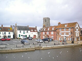
Wareham is a historic market town and, under the name Wareham Town, a civil parish, in the English county of Dorset. The town is situated on the River Frome eight miles (13 km) southwest of Poole.

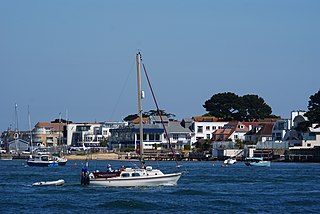
Sandbanks is an affluent neighbourhood of Poole, Dorset, on the south coast of England, situated on a narrow spit of around 1 km2 or 0.39 sq mi extending into the mouth of Poole Harbour.

Church Knowle is a village and civil parish on the Isle of Purbeck in the county of Dorset in the south of England.

Upton is a town in south-east Dorset, England. Upton is to the east of Holton Heath and Upton Heath, and to the north of the Poole suburb of Hamworthy. It is the second largest town in the Purbeck Hills.

Arne is a village and civil parish in Dorset, England, situated 4 miles (6.4 km) east of Wareham. The local travel links are located at Wareham railway station. Bournemouth International Airport is 11 miles (18 km) away. The main road through the village is Arne Road connecting Arne to Wareham. The village is situated on the Arne Peninsula, which protrudes into Poole Harbour opposite the town of Poole.

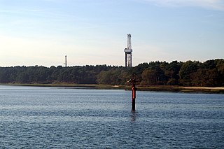
Wytch Farm is an oil field and processing facility in the Purbeck district of Dorset, England. It is the largest onshore oil field in Western Europe. The facility, taken over by Perenco in 2011, was previously operated by BP. It is located in a coniferous forest on Wytch Heath on the southern shore of Poole Harbour, two miles (3.2 km) north of Corfe Castle. Oil and natural gas (methane) are both exported by pipeline; liquefied petroleum gas is exported by road tanker.

Dorset is a rural county in south west England. Its archaeology documents much of the history of southern England.

Furzey Island is an island in Poole Harbour in the English county of Dorset. The island lies to the south of the larger Brownsea Island. Seen from the water, or adjoining land, the island looks like another wild pineclad island. However, hidden in the trees are twenty-two oil wells split into 2 well-sites for the Wytch Farm Oil Field, which is linked by pipeline to Hamble on Southampton Water. The rarely seen tall oil rig can sometimes be a big landmark of Southern Poole Harbour and the main landmark between Brownsea and Furzey. The well-sites are staffed 24 hours a day.

Green Island is an island in Poole Harbour in the English county of Dorset. It lies in the central south part of the harbour, south of Brownsea Island and Furzey Island. The island is an Area of Outstanding Natural Beauty (AONB), Site of Special Scientific Interest (SSSI), and Special Protection Area (SPA).

Parkstone is an area of Poole, Dorset. It is divided into 'Lower' and 'Upper' Parkstone. Upper Parkstone - "Up-on-'ill" as it used to be known in local parlance - is so-called because it is largely on higher ground slightly to the north of the lower-lying area of Lower Parkstone - "The Village" - which includes areas adjacent to Poole Harbour.

Round Island is an island in Poole Harbour in the English county of Dorset. It lies just off the shore of the Arne Peninsula in the south-west of the harbour, and is separated from the nearby uninhabited Long Island by a narrow channel only a few feet wide.

Dorset is a county located in the middle of the south coast of England. It lies between the latitudes 50.512°N and 51.081°N and the longitudes 1.682°W and 2.958°W, and occupies an area of 2,653 km2. It spans 90 kilometres (56 mi) from east to west and 63 kilometres (39 mi) from north to south.


