Related Research Articles
The Interior Plateau comprises a large region of the Interior of British Columbia, and lies between the Cariboo and Monashee Mountains on the east, and the Hazelton Mountains, Coast Mountains and Cascade Range on the west. The continuation of the plateau into the United States is known there as the Columbia Plateau.
Dean Channel is the upper end of one of the longest inlets of the British Columbia Coast, 105 km (65.2 mi) from its head at the mouth of the Kimsquit River. The Dean River, one of the main rivers of the Coast Mountains, enters Dean Channel about 9.5 km (5.9 mi) below the head of the inlet, at the community of Kimsquit.

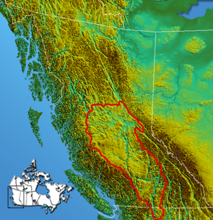
The Cariboo Plateau is a volcanic plateau in south-central British Columbia, Canada. It is part of the Fraser Plateau that itself is a northward extension of the North American Plateau. The southern limit of the plateau is the Bonaparte River although some definitions include the Bonaparte Plateau between that river and the Thompson, but it properly is a subdivision of the Thompson Plateau. The portion of the Fraser Plateau west of the Fraser River is properly known as the Chilcotin Plateau but is often mistakenly considered to be part of the Cariboo Plateau, which is east of the Fraser.
Shuswap Lake Marine Provincial Park is an 896-hectare provincial park in British Columbia, Canada, comprising 991 ha. The Park has a variety of amenities including boat launch ramps, picnic areas, and 27 campsites around the perimeter of Shuswap Lake. The lake's name and that of the surrounding Shuswap Country is from the Shuswap people (Secwepemc), the most northern of the Salishan speaking people.
Tsintsunko Lakes Provincial Park is a 333-hectare provincial park in British Columbia, Canada, located south of the Deadman River between Kamloops (SE) and Bonaparte Lake (NW). It is located on the Bonaparte Plateau. It was established April 30, 1996.
There are over 30 lakes named Mud Lake within the U.S. state of Washington.
The British Columbia Interior, BC Interior or Interior of British Columbia, usually referred to only as the Interior, is one of the three main regions of the Canadian province of British Columbia, the other two being the Lower Mainland, which comprises the overlapping areas of Greater Vancouver and the Fraser Valley, and the Coast, which includes Vancouver Island and also including the Lower Mainland.

The Bonaparte Indian Band a.k.a. Bonaparte First Nation, is a member band of the Shuswap Nation Tribal Council of the Secwepemc (Shuswap) people.
The Skeetchestn Indian Band is a member of the Secwepemc (Shuswap) Nation, located in the Central Interior region of the Canadian province of British Columbia. Its main Indian reserve is located at Savona, British Columbia. The reserve was set up in the 1860s when the government of the then-Colony of British Columbia established an Indian Reserve system. The Skeetchestn is a member government of the Shuswap Nation Tribal Council.
The Tŝideldel First Nation is the band government of the Tsi Del Del subgroup of the Tsilhqot'in people, located in the Chilcotin District in the western Central Interior region of the Canadian province of British Columbia. It is a member of the Tsilhqot'in National Government.

Alexandria or Fort Alexandria is a National Historic Site of Canada on the Fraser River in British Columbia, and was the end of the Old Cariboo Road and the Cariboo Wagon Road. It is located on Highway 97, 103 miles (166 km) north of 100 Mile House and 28 miles (45 km) south of Quesnel.
Bald Mountain is a name given to over fifty summits in California.
The Fraser Plateau is an intermontane plateau. It is one of the main subdivisions of the Interior Plateau located in the Central Interior of British Columbia.
Loon Lake, British Columbia may refer to one of a number of lakes in this province of Canada with this precise name or to others with similar names.
The Lillooet Land District is one of the 59 cadastral subdivisions of British Columbia, which were created by the Lands Act of the Colony of British Columbia in 1859, defined as "a territorial division with legally defined boundaries for administrative purposes". The land district's boundaries came to be used as the boundary of the initial Lillooet riding for the provincial Legislature from 1871, when the colony became a province. In addition to use in descriptions of land titles and lot surveys, the Land District was also the basis of the Lillooet Mining District.
There are 21 mountain peaks named West Peak in the United States according to the US Geological Survey Geographic Names Information System.
References
 | This article includes a list of lakes that share the same name (or similar names). If an internal link incorrectly led you here, you may wish to change the link to point directly to the intended lake article. |