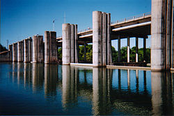
Longhorn Dam

Last updated
Longhorn Dam
Longhorn dam.jpg
The upstream side of Longhorn Dam in 2005
Relief map of Texas.png
Red pog.svg
Location of Longhorn Dam in Texas
Official nameLonghorn Dam
Location Austin, Texas, United States
Coordinates 30°15′1″N97°42′49″W / 30.25028°N 97.71361°W / 30.25028; -97.71361
Opening date1960 (1960)
Operator(s)City of Austin
Dam and spillways
Impounds Colorado River
Height36 feet (11 m)
Length506 feet (154 m)
Reservoir
Creates Lady Bird Lake
Surface area471 acres (191 ha)

Longhorn Dam is a dam crossing the Colorado River in Austin, Texas, United States, where it creates Lady Bird Lake. Completed in 1960, the dam was built by the City of Austin as the last in a chain of Colorado River dams in central Texas begun during the Great Depression. The name refers to its location on a ford used for longhorn cattle drives as a part of the Chisholm Trail in the late 19th century.

Contents

History

Longhorn Dam was constructed in the late 1950s to establish a cooling reservoir for Austin's Holly Street Power Plant, a 570-megawatt natural gas and fuel oil-fired electrical power plant. The reservoir it created, Lady Bird Lake, was also originally used as a source of drinking water for the city. [1] It is not a hydroelectric dam and generates no electrical power.

In 2007 the power plant was decommissioned and subsequently demolished to make way for a new lakeside urban park; [2] today the reservoir's major uses are recreation and fishing. The stabilization of the downtown shoreline that the dam afforded enabled substantial parkland development along the newly created lake, including Auditorium Shores and other parts of Town Lake Park. [3]

In the 2000s and 2010s the aging dam's floodgates experienced a series of malfunctions, causing on some occasions the loss of substantial amounts of water down the river (when gates failed to close properly).

The dam was originally constructed and operated by Austin Energy, the city power utility, but Austin Water took over operations of the dam in April 2018.

Since 2013, Austin Energy made several maintenance and upkeep projects to the dam such as replacing all major parts and rebuilding both hydraulic bascule systems. Austin Energy also repaired one of the gates and overhauled the mechanical lifting system.

City officials have estimated the cost of replacing the dam in the tens of millions of dollars. [4]

Between 2013 and 2018, Austin Energy spent $1.6 million in maintenance and repair costs.

Geography and hydrography

Longhorn Dam is located at 30.2504°, -97.7135° (WGS 84 datum), with a full water level at 428 feet (130 m) above sea level. The reservoir impoundment length is 5.75 miles (9.3 km), creating Lady Bird Lake (formerly called Town Lake), a freshwater lake with a surface area of 471 acres (191 ha). Water release through the dam varies with rainfall and with the seasonal demand for irrigation water downstream. [1]

Structure and function

The dam stands 36 feet (11 m) high and runs a length of 506 feet (154 m) across the Colorado River. It includes nine floodgates that are used to control water release and maintain a stable water level in the reservoir. Two are bascule gates that passively allow water to flow through to maintain Lady Bird Lake's water level; the other seven are lift gates that are controlled manually to adjust water flow in response to weather conditions and water releases for downstream ecology and irrigation. [4]

Related Research Articles

<span class="mw-page-title-main">Lady Bird Lake</span> Reservoir in Austin, Texas, United States

Lady Bird Lake is a river-like reservoir on the Colorado River in Austin, Texas, United States. The City of Austin created the reservoir in 1960 as a cooling pond for a new city power plant. The lake, which has a surface area of 416 acres (168 ha), is now used primarily for recreation and flood control. The reservoir is named in honor of former First Lady of the United States Lady Bird Johnson.

<span class="mw-page-title-main">Lake Travis</span> Reservoir in central Texas, USA

Lake Travis is a reservoir on the Colorado River in central Texas in the United States.

<span class="mw-page-title-main">Lake Austin</span> Man-made reservoir in Texas, United States

Lake Austin, formerly Lake McDonald, is a water reservoir on the Colorado River in Austin, Texas. The reservoir was formed in 1939 by the construction of Tom Miller Dam by the Lower Colorado River Authority. Lake Austin is one of the seven Highland Lakes created by the LCRA, and is used for flood control, electrical power generation, and recreation.

<span class="mw-page-title-main">Mansfield Dam</span> Dam in Texas, USA

Mansfield Dam is a dam located across a canyon at Marshall Ford on the Colorado River, 13 miles (21 km) northwest of Austin, Texas. The groundbreaking ceremony occurred on February 19, 1937, with United States Secretary of the Interior Harold L. Ickes attending. The dam was a joint project by the Lower Colorado River Authority (LCRA) and the United States Bureau of Reclamation, with partial funding provided by the Public Works Administration. Brown and Root, headed by James E. Walters, Sr., was the prime contractor. The dam was completed in 1941. Originally called Marshall Ford Dam, the name was changed in 1941 in honor of United States Representative J.J. Mansfield. The reservoir behind Mansfield Dam is named Lake Travis. The dam is owned and operated by the LCRA.

The Texas Highland Lakes are a chain of fresh water reservoirs in Central Texas formed by dams on the lower Colorado River. The Texas Colorado River winds southeast from West Texas to Matagorda Bay and the Gulf of Mexico.

<span class="mw-page-title-main">Lake Lyndon B. Johnson</span> Reservoir in the United States

Lake Lyndon B. Johnson is a reservoir on the Colorado River in the Texas Hill Country about 45 miles northwest of Austin. The reservoir was formed in 1950 by the construction of Granite Shoals Dam by the Lower Colorado River Authority (LCRA). The Colorado River and the Llano River meet in the northern portion of the lake at Kingsland.

<span class="mw-page-title-main">Inks Lake</span> Hydroelectric reservoir in Texas, United States

Inks Lake is a reservoir on the Colorado River in the Texas Hill Country in the United States. The reservoir was formed in 1938 by the construction of Inks Dam by the Lower Colorado River Authority. Located near Burnet, Texas, the lake serves to provide flood control in tandem with Lake Buchanan and features the smallest hydroelectric power plant on the Highland Lakes chain. Inks Lake was named for Roy B. Inks, one of the original board members of the Lower Colorado River Authority, and serves as a venue for outdoor recreation, including fishing, boating, swimming, camping, and picnicking.

<span class="mw-page-title-main">Spillway</span> Structure for controlled release of flows from a dam or levee

A spillway is a structure used to provide the controlled release of water downstream from a dam or levee, typically into the riverbed of the dammed river itself. In the United Kingdom, they may be known as overflow channels. Spillways ensure that water does not damage parts of the structure not designed to convey water.

<span class="mw-page-title-main">Parker Dam</span> Colorado River dam between Arizona and California

Parker Dam is a concrete arch-gravity dam that crosses the Colorado River 155 miles (249 km) downstream of Hoover Dam. Built between 1934 and 1938 by the Bureau of Reclamation, it is 320 feet (98 m) high, 235 feet (72 m) of which are below the riverbed (the deep excavation was necessary in order to reach the bedrock on which the foundation of the dam was built), making it the deepest dam in the world. The portion of the dam above the foundation stands 85 feet (25.9 m) tall, making it the only dam in the world that stands more underground than above ground. The dam's primary functions are to create a reservoir, and to generate hydroelectric power. The reservoir behind the dam is called Lake Havasu and can store 647,000 acre⋅ft (798,000,000 m3; 2.11×10¹¹ US gal; 1.76×10¹¹ imp gal). The dam straddles the Arizona-California state border at the narrows the river passes through between the Whipple Mountains in San Bernardino County, California and the Buckskin Mountains in La Paz County, Arizona.

<span class="mw-page-title-main">Reservoir</span> Storage space for water

A reservoir is an enlarged lake behind a dam. Such a dam may be either artificial, usually built to store fresh water, or it may be a natural formation.

<span class="mw-page-title-main">Nagarjuna Sagar Dam</span> Dam in Andhra Pradesh & Nalgonda district, Telangana

Nagarjuna Sagar Dam is a masonry dam across the Krishna River at Nagarjuna Sagar which straddles the border between Palnadu district in Andhra Pradesh and Nalgonda district in Telangana. The dam provides irrigation water to the districts of Palnadu, Guntur, Nalgonda, Prakasam, Khammam, Krishna, and parts of West Godavari. It is also a source of electricity generation for the national grid.

<span class="mw-page-title-main">Conowingo Dam</span> Dam in Cecil and Harford counties, Maryland

The Conowingo Dam is a large hydroelectric dam in the lower Susquehanna River near the town of Conowingo, Maryland. The medium-height, masonry gravity dam is one of the largest non-federal hydroelectric dams in the U.S., and the largest dam in the state of Maryland.

<span class="mw-page-title-main">Srisailam Dam</span> Dam in Andhra Pradesh and Telangana, India

The Srisailam Dam is constructed across the Krishna River in Nandyal district, Andhra Pradesh and Nagarkurnool district, Telangana near Srisailam temple town and is the 2nd largest capacity working hydroelectric station in India.

<span class="mw-page-title-main">Navajo Dam</span> Dam in San Juan and Rio Arriba Counties, New Mexico

Navajo Dam is a dam on the San Juan River, a tributary of the Colorado River, in northwestern New Mexico in the United States. The 402-foot (123 m) high earthen dam is situated in the foothills of the San Juan Mountains about 44 miles (71 km) upstream and east of Farmington, New Mexico. It was built by the U.S. Bureau of Reclamation (Reclamation) in the 1960s to provide flood control, irrigation, domestic and industrial water supply, and storage for droughts. A small hydroelectric power plant was added in the 1980s.

<span class="mw-page-title-main">Ujjani Dam</span> Dam in Madha Taluka, Solapur district

Ujjani Dam, also known as Bhima Dam or Bhima Irrigation Project, on the Bhima River, a tributary of the Krishna River, is an earthfill cum Masonry gravity dam located near Ujjani village of Madha Taluk in Solapur district of the state of Maharashtra in India.

<span class="mw-page-title-main">Rio Grande Project</span>

The Rio Grande Project is a United States Bureau of Reclamation irrigation, hydroelectricity, flood control, and interbasin water transfer project serving the upper Rio Grande basin in the southwestern United States. The project irrigates 193,000 acres (780 km2) along the river in the states of New Mexico and Texas. Approximately 60 percent of this land is in New Mexico. Some water is also allotted to Mexico to irrigate some 25,000 acres (100 km2) on the south side of the river. The project was authorized in 1905, but its final features were not implemented until the early 1950s.

<span class="mw-page-title-main">Risks to the Glen Canyon Dam</span> Aspect of dam construction

Glen Canyon Dam, a concrete arch dam on the Colorado River in the American state of Arizona, is viewed as carrying a large amount of risk, most notably due to siltation. The Colorado and San Juan rivers deposit large volumes of silt into Lake Powell, slowly decreasing its capacity. The sediment will eventually build up against the dam and could affect its safe operation and lead to its failure.

<span class="mw-page-title-main">New Exchequer Dam</span> Dam in Mariposa County, California

New Exchequer Dam is a concrete–faced, rock-fill dam on the Merced River in central California in the United States. It forms Lake McClure, which impounds the river for irrigation and hydroelectric power production and has a capacity of more than 1,000,000 acre-feet (1.2 km3). The Merced Irrigation District (MID) operates the dam and was also responsible for its construction.

<span class="mw-page-title-main">Steinhagen Reservoir</span>

B A Steinhagen Reservoir is located near the town of Jasper, Texas in the east Texas Piney Woods at 30.85 North Latitude and 94.19 West Longitude. The borders of Tyler County and Jasper County are defined by the bed of the Neches River, and therefore bisect the lake on a North/South line. The lake was created as part of a project that focused on creating lakes for recreation, power generation, and water conservation on the Neches River and the Angelina River. For many years, locals have referred to both the lake and dam as "Dam B".

References

  1. 1 2 "What are some general characteristics of each lake?". City of Austin . Retrieved 16 November 2015.
  2. Bernier, Nathan (18 July 2011). "City Finalizes Contract To Remove Holly Power Plant". KUT . Retrieved 16 November 2015.
  3. "Town Lake Park Project History". City of Austin . Retrieved 16 November 2015.
  4. 1 2 Buchele, Mose (5 March 2015). "This Dam Holds in Lady Bird Lake, So When Will It Get 'Essential' Repairs?". NPR StateImpact Texas. Retrieved 16 November 2015.