
Balsam Township is a township in Aitkin County, Minnesota, United States. The population was 42 as of the 2010 census.

The Saint Louis River is a river in the U.S. states of Minnesota and Wisconsin that flows into Lake Superior. The largest U.S. river to flow into the lake, it is 192 miles (309 km) in length and starts 13 miles (21 km) east of Hoyt Lakes, Minnesota. The river's watershed covers 3,634 square miles (9,410 km2). Near the Twin Ports of Duluth, Minnesota and Superior, Wisconsin, the river becomes a freshwater estuary. The lower St. Louis is the only river in the state with whitewater rafting opportunities.

The Arrowhead Region is located in the northeastern part of the U.S. state of Minnesota, so called because of its pointed shape. The predominantly rural region encompasses 10,635.26 square miles (27,545.2 km2) of land area and includes Carlton, Cook, Lake and Saint Louis counties. Its population at the 2000 census was 248,425 residents. Aitkin, Itasca, and Koochiching counties are also sometimes considered as part of the region. This would increase the land area to 18,221.97 square miles (47,194.7 km2) and the population to 322,073 residents.
Bachelor Lake is a lake in Brown County, Minnesota in the northeastern part of Stark township. Covering 79.80 acres, it is an officially protected water of the State of Minnesota. The lake is within the Cottonwood River Major Watershed. The lake’s elevation is 1,004 feet (306 m), and it is zoned as a shoreland area which is regulated as a shoreland management water.
The Sioux–Hustler Trail is a 35-mile (56 km) hiking trail in the Boundary Waters Canoe Area in northeastern Minnesota. The trail is approximately an hour's drive from Ely, Minnesota, along the Echo Trail. The trail, which is primitive and not well maintained, runs from the Little Indian Sioux River through relatively untouched country to Hustler Lake, which is at an altitude of 1,302 ft (397 m).
Markham is an unincorporated community in Colvin Township, Saint Louis County, Minnesota, United States.
Saginaw is an unincorporated area in Saint Louis County, Minnesota, United States. Although unincorporated, Saginaw has a post office with the ZIP code 55779.
Fairbanks is an unincorporated community in Fairbanks Township, Saint Louis County, Minnesota, United States; located within the Superior National Forest.
Kelly Lake is a neighborhood of the city of Hibbing in St. Louis County, Minnesota, United States. County Road 60 / Rainey Road / 1st Avenue serves as a main arterial route in the community. Previously, Kelly Lake was its own unincorporated community before it was annexed by the city of Hibbing. U.S. Route 169 is nearby.
The Jeanette State Forest is a state forest located in St. Louis County, Minnesota. The forest is within the limits of the Superior National Forest's Boundary Waters Canoe Area Wilderness, and thus falls under the federal jurisdiction and management of the United States Forest Service.
Little Coon Lake is a lake in Anoka County, Minnesota, in the United States.
Lake Mary is a lake in Douglas County, in the U.S. state of Minnesota.
Lake Plantagenet is a lake in the U.S. state of Minnesota.
Garden Lake is a lake in Lake County, in the U.S. state of Minnesota.
Lake Stay is a lake in Lincoln County, in the U.S. state of Minnesota.
Lake Washington is a lake located between Dassel and Darwin in Meeker County, in the U.S. state of Minnesota.
Lily Lake is a lake in Washington County, in the U.S. state of Minnesota.

Lake Saint Clair is a lake in the U.S. state of Washington. The lake has a surface area of 244 acres (99 ha) and reaches a depth of 110 feet (34 m).
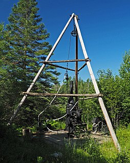
The Longyear Drill Site is a historic mineral exploration site in Hoyt Lakes, Minnesota, United States. In 1890 the first core samples were taken there from what would become known as the Mesabi Range, one of the world's richest iron ore deposits. The exploration diamond drilling process was led by Edmund J. Longyear, who went on to drill 7,100 test pits all across the Mesabi Range. In 1976 the Iron Range Historical Society developed the site as a historic attraction with period drilling equipment. It is now managed by the city of Hoyt Lakes in partnership with the Hoyt Lakes Garden Club.

