
Lake Michigan is one of the five Great Lakes of North America. It is the second-largest of the Great Lakes by volume and the third-largest by surface area, after Lake Superior and Lake Huron. To the east, its basin is conjoined with that of Lake Huron through the 3+1⁄2-mile (5.6-kilometer) wide, 295-foot deep Straits of Mackinac, giving it the same surface elevation as its easterly counterpart; the two are geologically a single lake.

Lake Agassiz was a large proglacial lake that existed in central North America during late Pleistocene, fed by meltwater from the retreating Laurentide Ice Sheet at the end of the last glacial period. At its peak, the lake's area was larger than all of the modern Great Lakes combined.

Lake Winnebago is a shallow freshwater lake in the north central United States, located in east central Wisconsin. At 137,700 acres, it is the largest lake entirely within the state, covering an area of about 30 miles by 10 miles with 88 miles of shoreline, an average depth of 15.5 feet, and a maximum depth of 21 feet. It has many shallow reefs along the west shore and a drop-off type shoreline on the east. There are several islands along the west shore.

Canadarago Lake is a 1,917-acre (7.76 km2) lake located in Otsego County, New York and is the source of Oaks Creek. The Village of Richfield Springs is located at the lake's northern end. It is the second largest lake in Otsego County, lying to the west of and parallel to the larger Otsego Lake. The lake's name is also spelled "Candajarago Lake" or "Caniadaraga Lake".

The Driftless Area, also known as Bluff Country, the Blufflands, the Paleozoic Plateau, and the Coulee Region, is a topographical and cultural region in the Midwestern United States that comprises southwestern Wisconsin, southeastern Minnesota, northeastern Iowa, and the extreme northwestern corner of Illinois. The Driftless Area is a USDA Level III Ecoregion: Ecoregion 52. The Driftless Area takes up a large portion of the Upper Midwest forest–savanna transition.
Trickey Pond is a water body in the U.S. state of Maine. Its maximum depth is 55 feet (17 m). The lack of serious pollution in the area contributes to the pond's remarkably good water clarity. At most points in the pond, the entire depth can be seen.
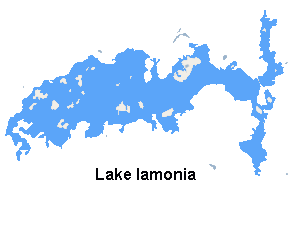
Lake Iamonia⟨aɪ ˈmoʊ njə⟩ is a large, subtropical prairie lake in northern Leon County, Florida, United States, created during the Pleistocene epoch.

Lake Wentworth is located in Carroll County in eastern New Hampshire, United States, in the town of Wolfeboro. At 3,097 acres (12.53 km2), it is the seventh-largest lake located entirely in New Hampshire. Water from Lake Wentworth flows through the short Smith River into Crescent Lake and then over the dam into Lake Winnipesaukee in Wolfeboro. The 50-acre (20 ha) Wentworth State Park offers public access to the lake.

Conway Lake is a 1,316-acre (5 km2) water body with a maximum depth of 45 feet (14 m), located in Carroll County in eastern New Hampshire, in the United States. The lake is located in the towns of Conway and Eaton, just to the east of the White Mountains, and is part of the Saco River watershed.

Goose Pond is a 625-acre (2.5 km2) water body located in Grafton County in western New Hampshire, United States, in the towns of Canaan and Hanover. It is considered a great pond by the state of New Hampshire. The lake has 6.3 miles (10.1 km) of shoreline, and is approximately 3 miles (5 km) long by 0.5 miles (0.8 km) wide. All but the northernmost end of the pond is in the town of Canaan. The average depth of the pond is approximately 10 feet (3.0 m), with the deepest part approximately 35 feet (11 m). The lake is part of the Mascoma River watershed, flowing to the Connecticut River.

Silver Lake is a 346-acre (1.40 km2) water body located in Cheshire County in southwestern New Hampshire, United States, in the towns of Harrisville and Nelson. Water from Silver Lake flows via Minnewawa Brook and The Branch to the Ashuelot River, a tributary of the Connecticut River.

The Kishwaukee River, locally known as simply The Kish, is a 63.4-mile-long (102.0 km) river in the U.S. state of Illinois. It is a tributary of the Rock River and its name derives from the Potowatomi word for "river of the sycamore".

Antioch Township is located in Lake County, Illinois, United States. The population was 27,745 at the 2010 census.

Silver Springs State Fish and Wildlife Area is an Illinois state park on 1,350 acres (550 ha) in Kendall County, Illinois, United States. The park was established in the late 1960s and is named for the natural spring within its boundaries. The park has two artificial lakes and the Fox River flows through the northern end of the park. Silver Springs hosts a variety of activities including fishing, hunting, boating and hiking. The park has areas of native prairie restoration, a sledding hill and a seven-mile (11 km) equestrian trail. The prairie restoration areas hold many species of plants including lead plant, and purple coneflower.
Skokie Lagoons is a nature preserve in Glencoe and Winnetka, Illinois, owned and managed by the Forest Preserve District of Cook County. The park is bordered by Dundee Road to the north, Forestway Drive to the east, Willow Road to the south, and the Edens Expressway to the west. Within the park, there are seven inter-connected lagoons totaling 190 acres (0.77 km2). Water flows southward from the Chicago Botanic Garden through the lagoons to the Skokie River. The overall water level in the lagoons is controlled by the main control dam at Willow Road. Three low dams keep the water levels below the inner islands. Recreational opportunities at Skokie Lagoons include biking, fishing, boating, and birding.

Lake Sunapee is located within Sullivan County and Merrimack County in western New Hampshire, the United States. It is the fifth-largest lake located entirely in New Hampshire.

Chocorua Lake is a picturesque lake in northeast New Hampshire with commanding views of the summit of Mount Chocorua. It is approximately 1.1 miles (1.8 km) long (north-south) with a maximum width of 3,500 feet (1.1 km) (east-west), covering 222 acres (90 ha), and a maximum depth of 27 feet (8.2 m).

Castle Rock Lake is an artificial lake on the Wisconsin River. It is located in central Wisconsin in Adams County and Juneau County. The lake has an inflow from Petenwell Lake, Yellow River, Big Roche a Cri., and Klien Creek. It has a surface area of 16,640 acres (67.3 km2) and its depth varies from 8–20 ft (2.4–6.1 m) in most places, with area in the old river beds reaching as deep as 35 ft (11 m).
Lovewell Pond is a sizable body of water located in southeastern Fryeburg, Maine. It has a moderately developed shoreline with approximately 75-80 buildings, not including approximately 35 others with access rights to the pond's shoreline.
Diamond Lake is a glacial-origin lake in the village of Mundelein in northeastern Lake County, Illinois. The lake has an average depth of 7.61 feet (2.32 m), a maximum depth of 23 feet (7.0 m) a shoreline of 5.9 miles (9.5 km), and a surface area of 153 acres (62 ha). The lake's watershed contains about 686.16 acres (277.68 ha) of residential and agricultural land surrounding the lake. Diamond Lake's water is replenished by precipitation and runoff within its watershed. Water exits the lake via a drainage pipe that eventually connects to the Des Plaines River.


