
The Forest of Bowland, also known as the Bowland Fells and formerly the Chase of Bowland, is an area of gritstone fells, deep valleys and peat moorland, mostly in north-east Lancashire, England, with a small part in North Yorkshire. It is a western outlier of the Pennines.
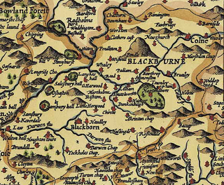
Blackburn Hundred is a historic sub-division of the county of Lancashire, in northern England. Its chief town was Blackburn, in the southwest of the hundred. It covered an area similar to modern East Lancashire, including the current districts of Ribble Valley, Pendle, Burnley, Rossendale, Hyndburn, Blackburn with Darwen, and South Ribble.

Newton or Newton-in-Bowland is a village and civil parish in the Ribble Valley district, in the county of Lancashire, England, formerly known as Newton-on-Hodder. The civil parish had a population of 237 in 2001, according to the United Kingdom Census, increasing to 315 at the 2011 Census. The township covers almost 6,000 acres of the Forest of Bowland. Historically, the village is part of the West Riding of Yorkshire, but was transferred to Lancashire for administrative purposes on 1 April 1974, under the provisions of the Local Government Act 1972.
Dunsop Bridge is a village in the civil parish of Bowland Forest High, in the borough of Ribble Valley, Lancashire, England, 9 miles (14 km) north-west of Clitheroe, 15 miles (24 km) south-east of Lancaster and 24.5 miles (39 km) west of Skipton. Historically, the village is part of the West Riding of Yorkshire, but was placed under the administration of Lancashire County Council on 1 April 1974.

Bashall Eaves is a village and civil parish in the Ribble Valley district of Lancashire, England, about four miles (6 km) west of Clitheroe. The placename element eaves is Old English and refers to Bashall's location on the borders of the Forest of Bowland. Historically, the village is part of the West Riding of Yorkshire, but was transferred to Lancashire for administrative purposes on 1 April 1974, under the provisions of the Local Government Act 1972.

Slaidburn is a village and civil parish within the Ribble Valley district of Lancashire, England. The parish covers just over 5,000 acres of the Forest of Bowland.

Bowland Forest Low is a civil parish in the Ribble Valley district of Lancashire, England, covering some 5,500 acres (22 km2) of the Forest of Bowland. According to the 2001 census, the parish had a population of 168, falling to 160 at the 2011 Census. The parish includes the hamlets of Whitewell and Cow Ark. From northwards clockwise, it borders the civil parishes of Newton, Bashall Eaves, Aighton, Bailey and Chaigley, Bowland-with-Leagram and Bowland Forest High. Before 1974, it formed part of Bowland Rural District in the West Riding of Yorkshire.

Bowland Forest High is a civil parish in the Ribble Valley district of Lancashire, England, covering some 20,000 acres (80 km2) of the Forest of Bowland. It fell within the ancient boundaries of the West Riding of Yorkshire. According to the 2001 census, the parish had a population of 163, falling to 144 at the 2011 Census. The parish includes the settlements of Hareden, Sykes, and Dunsop Bridge. It covers Sykes Fell, Whins Brow, Croasdale Fell and Wolfhole Crag. Before 1974, it formed part of Bowland Rural District in the West Riding of Yorkshire.

Bowland-with-Leagram is a civil parish in the Ribble Valley district of Lancashire, England, covering part of the Forest of Bowland. According to the census, the parish had a population of 181 in 1951, 128 in 2001 and 169 at the Census 2011.

de Lacy is the surname of an old Norman family which originated from Lassy, Calvados. The family took part in the Norman Conquest of England and the later Norman invasion of Ireland. The name is first recorded for Hugh de Lacy (1020–1085). His sons, Walter and Ilbert, left Normandy and travelled to England with William the Conqueror. The awards of land by the Conqueror to the de Lacy sons led to two distinct branches of the family: the northern branch, centred on Blackburnshire and west Yorkshire was held by Ilbert's descendants; the southern branch of Marcher Lords, centred on Herefordshire and Shropshire, was held by Walter's descendants.

Waddington is a small village, 2 miles (3 km) north-west of Clitheroe in the Ribble Valley, Lancashire, England. The population of the civil parish at the 2011 census was 1,028. Before the 1974 county boundary changes, Waddington fell just within the Bowland Rural District of the West Riding of Yorkshire. It covers approximately 2000 acres of the Forest of Bowland.

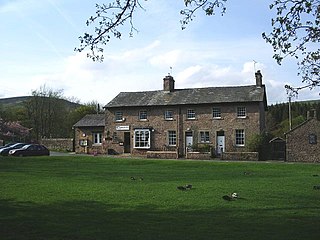
Whitewell is a village within the civil parish of Bowland Forest Low and Ribble Valley borough of Lancashire, England. It is in the Forest of Bowland Area of Outstanding Natural Beauty. Historically, the village fell just within the boundaries of the West Riding of Yorkshire. It was transferred to Lancashire for administrative purposes on 1 April 1974, under the provisions of the Local Government Act 1972. It stands above a bend in the River Hodder.

West Bradford is a village and civil parish in Lancashire, England, 2.5 miles (4 km) north of Clitheroe. The population at the 2011 census was 788. It covers some 2000 acres of the Forest of Bowland. In Domesday, it is recorded as Bradeford and in the thirteenth century, Braford in Bouland. It was part of the West Riding of Yorkshire until 1974. "West Bradford" was introduced in the nineteenth century at the start of postal services to distinguish the village from the city of the same name.
In Old English law, a Bowbearer was an under-officer of the forest who looked after all manner of trespass on vert or venison, and who attached, or caused to be attached, the offenders, in the feudal Court of Attachment.

Grindleton is a village and civil parish in the Ribble Valley district of the English county of Lancashire, traditionally in the West Riding of Yorkshire. Its 3,700 acres sit within the Forest of Bowland. The population of the civil ward taken at the 2011 census was 772.

The Honour of Clitheroe is an ancient grouping of manors and royal forests centred on Clitheroe Castle in Lancashire, England; an honour traditionally being the grant of a large landholding complex, not all of whose parts are contiguous. In the case of Clitheroe, this complex was loosely clustered around the ancient wapentake of Blackburnshire.

Great Mitton is a village and a civil parish in the Ribble Valley, Lancashire, England. It is separated from the civil parish of Little Mitton by the River Ribble, both lie about three miles from the town of Clitheroe. The combined population of both civil parishes at the 2011 census was 266. In total, Great and Little Mitton cover less than 2000 acres of the Forest of Bowland, making it the smallest township in the Forest. Historically, the village is part of the West Riding of Yorkshire, but was transferred to Lancashire for administrative purposes on 1 April 1974, under the provisions of the Local Government Act 1972.
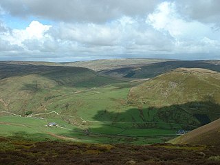
Lord of the Fells is a customary title of the Lords of Bowland. The title is thought to have become customary during the high medieval period as a description of the Lords' rugged upland demesne. Bowland Fells, more widely known as the Forest of Bowland, is an area of barren gritstone fells, deep valleys and peat moorland, mostly in north-east Lancashire, England. A small part lies in North Yorkshire, and much of the area was historically part of the West Riding of Yorkshire.
Easington is a civil parish within the Ribble Valley district of Lancashire, England, with a population in 2001 of 52. The Census 2011 population details have been grouped with the parish of Slaidburn. Before 1974, it formed part of Bowland Rural District in the West Riding of Yorkshire. It covers just over 9000 acres.

Lord of Balvaird or Baron of Balvaird is a title of nobility in the Baronage of Scotland. It was originally confirmed by James VI in 1624 for Andrew Murray as a barony and later erected into a lordship in favour of David Murray, 5th Viscount of Stormont in 1673.
