
Salta is a province of Argentina, located in the northwest of the country. Neighboring provinces are from the east clockwise Formosa, Chaco, Santiago del Estero, Tucumán and Catamarca. It also surrounds Jujuy. To the north it borders Bolivia and Paraguay and to the west lies Chile.

San Pedro de Atacama is a Chilean town and commune in El Loa Province, Antofagasta Region. It is located east of Antofagasta, some 106 km (60 mi) southeast of Calama and the Chuquicamata copper mine, overlooking the Licancabur volcano. It features a significant archeological museum, the R. P. Gustavo Le Paige Archaeological Museum, with a large collection of relics and artifacts from the region. Native ruins nearby attract increasing numbers of tourists interested in learning about pre-Columbian cultures.

Aracar is a large conical stratovolcano in northwestern Argentina, just east of the Chilean border. It has a main summit crater about 1–1.5 kilometres (0.6–0.9 mi) in diameter which sometimes contains crater lakes, and a secondary crater. The volcano has formed, starting during the Pliocene, on top of a lava platform and an older basement. Constructed on a base with an altitude of 4,100 metres (13,500 ft), it covers a surface area of 192.4 square kilometres (74.3 sq mi) and has a volume of 148 cubic kilometres (36 cu mi). The only observed volcanic activity was a possible steam or ash plume on March 28, 1993, seen from the village of Tolar Grande about 50 km (31 mi) southeast of the volcano, but with no evidence of deformation of the volcano from satellite observations. Inca archeological sites are found on the volcano.

The Tren a las Nubes is a tourist train service in Salta Province, Argentina. The service runs along the eastern part of the Salta–Antofagasta railway line of the Belgrano Railway that connects the Argentine Northwest with the border in the Andes mountain range, over 4,220 metres (13,850 ft) above mean sea level, the fifth highest railway in the world. Originally built for economic and social reasons, it is now primarily of interest to tourists as a heritage railway, though cheaper tickets are also available for locals to use the train as transport.
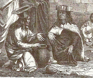
The Atacama people, also called Atacameño, are indigenous people from the Atacama Desert and altiplano region in the north of Chile and Argentina and southern Bolivia, mainly Antofagasta Region.

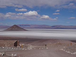
The Puna de Atacama or Atacama Plateau is an arid high plateau, in the Andes of northern Chile (15%) and Argentina (85%). Geomorphologist Walther Penck based his Grossfalt landform association on Puna de Atacama.

San Antonio de los Cobres is a small town of population 5,482 in northwestern Argentina. It is the capital of the Los Andes Department of the Salta Province.
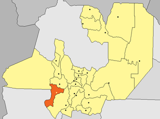
Mina La Casualidad is an abandoned mine and ghost town in Salta Province in northwestern Argentina.

Tolar Grande is a village and rural municipality in Salta Province in northwestern Argentina.

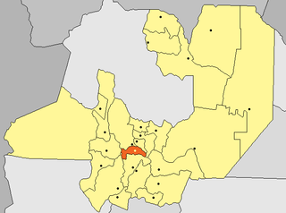
Capital is a department located in Salta Province, Argentina. It is the department of the provincial capital, the city of Salta, and the most populated one.

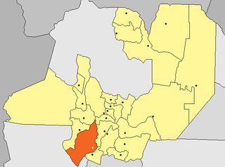
Rosario de Lerma is a department located in Salta Province, Argentina. Its main settlements are Rosario de Lerma and Campo Quijano.

La Poma is a department located in Salta Province, Argentina. It is the least populated department of the province and its capital is the town of La Poma.

The Salta–Antofagasta railway, also named Huaytiquina, is a non-electrified single track railway line that links Argentina and Chile passing through the Andes. It is a 1,000 mmmetre gauge railway with a total length of 941 km, connecting the city of Salta (Argentina) to the one of Antofagasta (Chile), on the Pacific Ocean, passing through the Puna de Atacama and Atacama Desert.

Sico Pass is a mountain pass on the border between Argentina and Chile. The pass is located on the main divide of the Andes. Administratively, it separates the province of Salta in Argentina and the region of Antofagasta in Chile.
Chicoana is a department located in Salta Province, in northwestern Argentina.
San Carlos is a department located in Salta Province, in Argentina.
Salar de Arizaro is a large salt flat of the Andes in north-western Argentina. It is located between the villages of Tolar Grande and Caipe and near Mina La Casualidad, in Los Andes Department, Salta Province.

Nevado de Acay is a 5,950-metre-high (19,520 ft) mountain in Argentina. It is a volcanic intrusion that formed during the Miocene and was later exposed. The intrusion is formed by monzonite and is associated with a fault system that also connects to neighbouring volcanoes.
Molinos is a department located in Salta Province, Argentina.

Salar del Hombre Muerto is a salt pan in Argentina, in the Antofagasta de la Sierra Department on the border between the Salta and Catamarca Provinces. It covers an area of 600 square kilometres (230 sq mi) and is in part covered by debris. During the Pleistocene it was sometimes a lake, but today only parts of the salt pan are covered by perennial water bodies; its major tributary is the Rio de Los Patos.


