Los Nevados National Natural Park

Last updated
Los Nevados National Natural Park
Parque Nacional Natural Los Nevados
Losnevados.jpg
Aerial view of Los Nevados National Park
Colombia relief location map.jpg
Red pog.svg
Location Caldas, Risaralda, Quindío and Tolima, Colombia
Nearest city Armenia - Ibagué - Manizales - Pereira
Coordinates 4°48′00″N75°22′00″W / 4.8°N 75.366667°W / 4.8; -75.366667
Area58,300 hectares (225 sq mi)
Established1973
Visitors39,904(in 2016)
Governing body SINAP
Website

Los Nevados National Natural Park (Spanish : Parque Nacional Natural Los Nevados) is a national park located in the Cordillera Central of the Colombian Andes. The park surrounds the northern volcanic complex formed by Nevado del Ruiz, Nevado del Tolima, Nevado de Santa Isabel, the paramillos of Cisne, Santa Rosa and Quindío and the Cerro Bravo and Cerro Machín.

Contents

The park is located in the departments of Caldas, Quindío, Risaralda, Tolima and spans between the municipalities Manizales, Villamaría, Santa Rosa de Cabal, Pereira, Salento, Villahermosa, Anzoátegui, Santa Isabel, Murillo, Ibagué and Casabianca.

State of the Park

The park was temporarily closed by the authorities since March 31, 2023 because the Nevado del Ruiz Volcano has increased its activity and there are fears of a possible eruption.

Entrance through Brisas sector (northern sector of the Park) is only allowed to Valle de las Tumbas since the Servicio Geológico Colombiano has declared Nevado del Ruiz Volcano's activity at Orange Alert Level (level II). It is highly recommend for visitors to consult the state of volcanic activity in the Servicio Geológico Colombiano's web page before their visit.

On Agust 10 2023, the National Natural Parks of Colombia issued the resolution to open the park, authorizing the entrance to visitors, so its possible to visit it again. Take into account the new acess hours to the park, which are from Monday to Sunday from 7:00 a.m. to 2:00 p.m.

Geology

Glacial activity has shaped the park's landscape 3,000 m (9,800 ft) above mean sea level, leaving U-shaped valleys and moraines behind. Extrusive igneous rock is dominant above 3,500 m (11,500 ft) on the eastern slopes and 2,200 m (7,200 ft) on the western slopes. [1] The Otún Lake, which lies in an extinct volcano crater, [2] and the Green Lake are located in the area.

Hydrography

The protected area is important for the region because of the countless sources of water that originate within. Glaciers occupy 4% of the area belonging to the three volcanoes, Nevado del Ruiz, Nevado de Santa Isabel and Nevado del Tolima. The melting waters from the glaciers give birth to the rivers that originate in the park and that conform 10 basins and 19 streams of different sizes and characteristics; six of the basins flow into the Magdalena River watershed (Gualí, Lagunilla, Recio, Totare and Coello) and the remaining four (Chinchiná, Campoalegre, Otún and Quindío) into the Cauca River watershed.

The park's hydrographic networks supply water to over for 2,000,000 inhabitants in the region, to coffee-growers and to most of the rice and cotton crops in the Tolima Department. [2]

The Otún wetland system, located within the Park, was declared an internationally important Ramsar Convention wetland.

Glacial retreat

In 2002, IDEAM warned about the alleged melting of the ice caps of the snow-capped mountains of the national park. Proof of this is the disappearance of the Ice Cathedrals, which were huge caverns in the lower part of the Nevado del Ruiz glacier, which existed before 1995 and which used to be frequented by climbers.

At the end of the 19th century, six glaciers existed on the peaks of El Ruiz, Santa Isabel, Tolima, El Cisne, Quindío and the current Paramillo de Santa Rosa, and were located at an altitude of 4500 meters above sea level.

The phenomenon of glacial retreat has worsened during the second half of the twentieth century. Of the former six existing glaciers, there are currently only three: El Nevado del Ruiz, Nevado de Santa Isabel and Nevado de Tolima. The three others had melted completely by the end of the 1970s. The surviving glaciers face a constant process of melting, the situation being critical for the Nevado del Tolima and Santa Isabel, whose area does not exceed two square kilometers. These two glaciers are expected to disappear completely between 2030 and 2040.

Flora and fauna

The park is composed of diverse ecosystems that change depending on the altitude. The lower regions of the park are composed of Andean forests, high Andean forests and high Andean wetlands. The higher regions of the park consist of the páramo and super-páramo ecosystems. The páramo is composed of grassland, peat bog, scrubland, swamps and lagoons and occupies 80% of the park's area. The super-páramo is a lunar-like landscape, composed of rocks, ashes, and sparse vegetation.

Flora

The area is home to 1250 species of vascular plants, 200 bryophytes, 300 lichens and 180 macroscopic fungi. [1] On the lower slopes and in the valleys the Andean wax palms are dominant. The upper Andean forest has trees reaching up to 30 m (98 ft) in height. [2] In the páramo, frailejones dominate the landscape and a range of mosses, lichens can be observed. Coulored algae can be found in the various lagoons.

Fauna

Noteworthy birds include blue-crowned motmot, yellow-eared parrot, Fuertes's parrot, rufous-fronted parakeet, Andean condor, brown-banded antpitta and ruddy duck. The buffy helmetcrest hummingbird is endemic to the region. [1] [2] [3] Noteworthy mammals include the mountain tapir, spectacled bear, northern pudú, oncilla, cougar and white-eared opossum. [2]

Footnotes

  1. 1 2 3 Rangel-Ch., J. Orlando; Garzón-C., Aída (1997). "Region of Los Nevados Natural National Park". In Davis, S.D.; Heywood, V.H.; Herrera-MacBryde, O.; Villa-Lobos, J.; Hamilton, A. (eds.). Centres of Plant Diversity: A Guide and Strategy for Their Conservation. Volume 3: The Americas. Cambridge, England: World Wide Fund for Nature, International Union for Conservation of Nature and Natural Resources. ISBN   2-8317-0199-6. Archived from the original on 9 July 2010. Retrieved 11 July 2010..
  2. 1 2 3 4 5 "Nature & Science Los Nevados". Parques Nacionales Naturales de Colombia. Archived from the original on 7 July 2011. Retrieved 11 July 2010.
  3. IUCN 1982 , p. 144

Related Research Articles

<span class="mw-page-title-main">Nevado del Ruiz</span> Volcanic mountain in Colombia

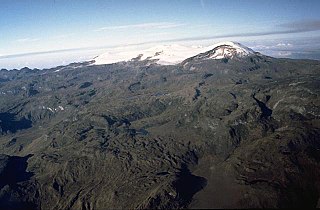
Nevado del Ruiz, also known as La Mesa de Herveo is a volcano on the border of the departments of Caldas and Tolima in Colombia, about 129 km (80 mi) west of the capital city Bogotá. It is a stratovolcano composed of many layers of lava alternating with hardened volcanic ash and other pyroclastic rocks. Volcanic activity at Nevado del Ruiz began about two million years ago, during the Early Pleistocene or Late Pliocene, with three major eruptive periods. The current volcanic cone formed during the present eruptive period, which began 150,000 years ago.

<span class="mw-page-title-main">Risaralda Department</span> Department of Colombia

Risaralda is a department of Colombia. It is located in the western central of the country, in the Andean region, It is part of the Coffee axis with Caldas and Quindío. Its capital is Pereira. Risaralda is very well known for the high quality of its coffee, and a booming industry: automotive, clothes, food, trading of goods and services.

<span class="mw-page-title-main">Pereira, Colombia</span> City in Risaralda, Colombia

Pereira is the capital city of the Colombian department of Risaralda. It's located in the foothills of the Andes in a coffee-producing area of Colombia officially known as the "Coffee Axis". Pereira, alongside the rest of the Coffee Axis, form part of UNESCO World Heritage Site known as the "Coffee Cultural Landscape of Colombia". It's the most populated city in the Coffee Axis. Pereira is also part of the Central West Metropolitan Area, which has 735.769 residents and is composed of Pereira and the neighboring cities of Dosquebradas and La Virginia. It's considered the most important city in the "Coffee Axis" from a geopolitical and economic standpoint.

<span class="mw-page-title-main">Armero tragedy</span> December 1985 volcanic eruption in Colombia

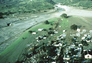
The Armero tragedy occurred following the eruption of the Nevado del Ruiz stratovolcano in Tolima, Colombia, on November 13, 1985. The volcano's eruption after 69 years of dormancy caught nearby towns unaware, even though volcanological organizations had warned the government to evacuate the area after they detected volcanic activity two months earlier.

<span class="mw-page-title-main">Murillo, Tolima</span> Municipality and town in Tolima Department, Colombia

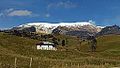
Murillo is a town and municipality in the Tolima department of Colombia. The population of the municipality was 4,953 as of the 2005 census, 1,569 who lived within the town of Murillo, the remainder in rural areas of the municipality.

<span class="mw-page-title-main">Lake Otún</span>

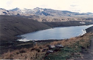
Lake Otún is a small lake in the Nevados National Park, in the Risaralda department of Colombia. It located at an altitude of 3,900 m over an extinct crater and has an area of 1.5 square kilometres. The lake is of glacial origin and is fed by meltwaters of the Nevado Santa Isabel. Lake Otún is the source of the Otún River, which supplies drinking water to the cities of Pereira and Dosquebradas.

<span class="mw-page-title-main">Colombian coffee growing axis</span> Region of Colombia known for growing coffee

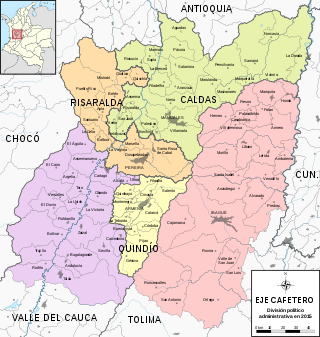
The Colombian coffee region, also known as the Coffee Triangle is a part of the Paisa region in the rural area of Colombia. It is famous for growing and producing the majority of Colombian coffee. There are four departments in the area: Caldas, Quindío, Risaralda and Tolima. The most visited cities are Manizales, Armenia, Pereira, and Ibagué.

<span class="mw-page-title-main">Cordillera Central (Colombia)</span> Branch of the Colombian Andes

The Cordillera Central is the highest of the three branches of the Colombian Andes. The range extends from south to north dividing from the Colombian Massif in Cauca Department to the Serranía de San Lucas in Bolivar Departments. The highest peak is Nevado del Huila at 5,364 m (17,598 ft).

<span class="mw-page-title-main">Tolima Department</span> Department of Colombia

Tolima is one of the 32 departments of Colombia, located in the Andean region, in the center-west of the country. It is bordered on the north and the west by the department of Caldas; on the east by the department of Cundinamarca; on the south by the department of Huila, and on the west by the departments of Cauca, Valle del Cauca, Quindío and Risaralda. Tolima has a surface area of 23,562 km2, and its capital is Ibagué. The department of Tolima was created in 1861 from a part of what was previously Cundinamarca.

<span class="mw-page-title-main">Cocora Valley</span> Valley in Quindío, Colombia

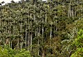
The Cocora valley is a valley in the Quindío Department of Colombia. It is located in the Central Cordillera of the Andean mountains. "Cocora" was the name of a Quimbayan princess, daughter of the local chief Acaime, and means "star of water".

<span class="mw-page-title-main">Nevado del Quindío</span>

The Nevado del Quindío is an inactive volcano located in the Central Cordillera of the Andes in central Colombia. The summit marks the tripoint of the departments of Risaralda, Quindío and Tolima, and is also the highest point of the departments of Risaralda and Quindío. The mountain is one of the highest peaks in the Los Nevados National Natural Park, which is a wildlife sanctuary. There are no historical records of any eruption. The andesitic volcano is located on top of the Palestina Fault.

<span class="mw-page-title-main">Nevado del Tolima</span> Active volcano in Colombia

The Nevado del Tolima is a Late Pleistocene to recently active andesitic stratovolcano located in the Tolima department, Colombia. The volcano lies south of Nevado del Ruiz volcano and is situated within the Los Nevados National Natural Park. The volcano, whose most recent activity dates to 1943 and last major eruption around 3600 years ago, overlies the Eocene El Bosque Batholith, dated at 49.1 ± 1.7 Ma.

<span class="mw-page-title-main">Santa Isabel (volcano)</span>

Santa Isabel is a shield volcano located in Tolima, Colombia, southwest of Nevado del Ruiz volcano. The volcano is located over the Palestina Fault, that crosscuts the underlying El Bosque Batholith of Eocene age, dated at 49.1 ± 1.7 Ma.

<span class="mw-page-title-main">Puracé</span> Volcanic mountain in Colombia

Puracé is an andesitic stratovolcano located in the Puracé National Natural Park in the Cauca Department, Colombia. It is part of the North Volcanic Zone of the Andean Volcanic Belt. The volcano is located at the intersection of the Coconucos and Morras Faults.

<span class="mw-page-title-main">Doña Juana</span> Active volcano in Colombia

Doña Juana is a stratovolcano, located within the Doña Juana-Cascabel Volcanic Complex National Natural Park in Nariño, Colombia.

<span class="mw-page-title-main">San Juan de Rioseco</span> Municipality and town in Cundinamarca, Colombia

San Juan de Rioseco is a municipality and town of Colombia in the department of Cundinamarca with a population of about 10,000 people. It lies in mountainous terrain in the coffee land at an altitude of about 4,000 feet, high above the Magdalena River, on the western slope of Colombia's eastern cordillera about 60 miles from Bogotá by car. On a clear day the snow-capped peaks of four volcanos in the central cordillera can be seen in the distance to the west.

The Nevado El Cisne is a volcano in the Central Ranges of the Andes in Colombia. Its summit is at an altitude of 4,636 metres (15,210 ft). The mountain is one of the five lava domes of the Nevado del Ruiz volcano complex. Despite the nevado part of the name, indicating a permanently snow-capped mountain, the summit of El Cisne is now below the permanent snow line as a result of global warming, and it is no longer considered a true nevado. The volcano is located over the Palestina Fault, that crosscuts the underlying El Bosque Batholith of Eocene age, dated at 49.1 ± 1.7 Ma.

<span class="mw-page-title-main">Buffy helmetcrest</span> Species of hummingbird

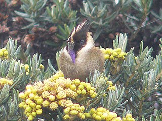
The buffy helmetcrest is a Vulnerable species of hummingbird in the "coquettes", tribe Lesbiini of subfamily Lesbiinae. It is endemic to Colombia.

References

Commons-logo.svg Media related to Parque Nacional Natural de los Nevados at Wikimedia Commons