
Chacao is one of the five political and administrative subdivisions of the city of Caracas, Venezuela. The other four are Baruta, El Hatillo, Libertador and Sucre. This legal entity is known as the Caracas Metropolitan District. Chacao is also one of the 21 municipalities that make up the State of Miranda, Venezuela.

Altamira is a neighborhood located in the Chacao municipality of Caracas, Venezuela. It has its own Metro Station, many hotels and restaurants, and it is an important business and residential center of the city. It is also an important tourist destination and cultural center in Caracas. The Francisco de Miranda avenue and the Distibuidor Altamira are both located in Altamira. This neighborhood borders El Ávila National Park to the north, La Castellana neighborhood to the west, Los Palos Grandes to the east, and Bello Campo neighborhood to the south. It has an estimated area of 161 hectares or approximately 1.61 square kilometers.

The Libertador Bolivarian Municipality is the only administrative division of the Capital District of Venezuela and along with the municipalities of Baruta, Chacao, El Hatillo and Sucre forms the Metropolitan District of Caracas. It is landlocked by Vargas State and also borders Miranda State on the east and south. The municipality is one of a number in Venezuela named "Libertador Municipality", in honour of Venezuelan independence hero Simón Bolívar.

Dulce Nombre de Jesus de Petare is a neighborhood in Miranda, Venezuela, and is part of the Metropolitan District of Caracas. It is located in the Sucre Municipality, one of the five divisions of Caracas. The city was founded in 1621 under the name of San Jose de Guanarito. It grew to become a part of the Greater Caracas area as the latter expanded in area and population. Petare had a population of 372,106 inhabitants and about 448,861 according to 2020 estimates. Petare is the biggest slum in Venezuela, and in South America.

The Francisco Fajardo Highway is the most important freeway of Caracas, connecting the west and east sides of the city. The national freeways and many of the avenues of Caracas are not designated with a system of codification or numbering; instead they are designated with the names of historical personages. This highway is named for the conquistador Francisco Fajardo. Also in Caracas, the connections between freeways are also given peculiar names - the octopus, the spider and the centipede are examples.
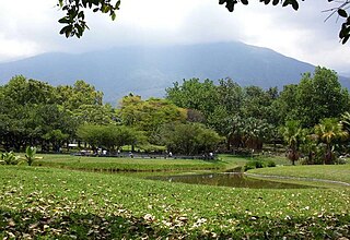
El Parque del Este, renamed as officially Generalissimo Francisco de Miranda Park by Chávez since, in honor of the Venezuelan national hero, is a public recreation park located in the Sucre Municipality of Metropolitan Caracas in Venezuela. Opened in 1961, it is one of the most important of the city, with an area of 82 hectares. The park was designed by Roberto Burle Marx and associates Fernando Tabora and John Stoddart.

El Rosal is a neighbourhood of Caracas, Venezuela, in the Chacao municipality. It is located at East Caracas, near the geographic center of Caracas and is one of its financial centres. It has an estimated area of 50.9 hectares
La Castellana is a district in Caracas, Venezuela, located in the northeast part of the city, La Castellana is bordered on the south by Chacao, on the east by Altamira (Caracas) neighbourhood, on the west by Caracas Country Club and Campo Alegre neighbourhood and on the north by El Ávila National Park. It has an approximate surface of 98 hectares.

Campo Alegre is a residential neighborhood located in the Chacao municipality of Caracas, Venezuela. This district holds the hotel Embassy Suites by Hilton , and the most exclusive party room of the city, the "Quinta Esmeralda", meeting point of the Venezuelan upper-class families.
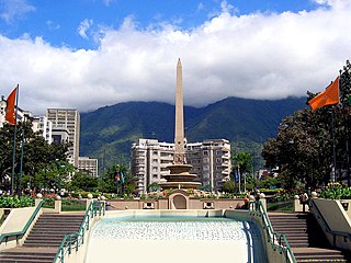
France Square, also known as "Plaza Altamira", is a public space located in Altamira, east Caracas. It was built at the beginning of the 1940s and opened on August 11, 1945, with the original name of "Plaza Altamira". Its name was later changed due to an agreement between the cities of Caracas and Paris to have a Venezuela Square in Paris and a France Square in Caracas. This square was designed by town planner Luis Roche within the project of "Altamira neighborhood", a wealthy district of Chacao municipality in Miranda States.

East Caracas generally refers to the eastern portions of Caracas, and may refer specifically to the municipalities from the Metropolitan District of Caracas located in Miranda State: Chacao, Baruta, Sucre, and El Hatillo. It concentrates the 34.8% population of the Metropolitan District of Caracas, and the 21.7% population of the Greater Caracas Area. Caracas Country Club, the richest neighborhood of the city, is located between El Recreo and Chacao districts.

The Sabana Grande district is divided into several middle class neighborhoods located in the Parroquia El Recreo of the Libertador Municipality, in the geographical center of the Metropolitan District of Caracas. It owes its name to the old town of Sabana Grande.
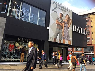
The Boulevard of Sabana Grande is an important leisure and shopping area located in eastern Caracas in the geographic center of the Metropolitan District of Caracas. It is a pedestrian-only, tree-shaded public space. In 2011, the boulevard of Sabana Grande went through a rehabilitation process founded by PDVSA La Estancia. A commercial and financial district, Sabana Grande is the commercial corridor, and a tourist district of Caracas. The boulevard of Sabana Grande is home to the most important ornithological collection in Latin America, the William Phelps Ornithological Collection. Until the beginning of the 20th century, it was called Calle Real because it was the town's main road.

El Cafetal is a neighborhood located in the Baruta Municipality of Caracas, Venezuela.

Chacao is a Caracas Metro station on Line 1. It was opened on 23 April 1988 as part of the extension of Line 1 from Chacaíto to Los Dos Caminos. The station is between Chacaíto and Altamira.

Diana López is a Venezuelan visual artist and cultural manager. She developed her artistic style in the nineties, focusing on participation and exchange with other people in the production of her pieces. In 1994, she became the first woman to receive the Eugenio Mendoza Prize. Her work ranges from photography and video to performance and installations. López was director of culture for the Chacao municipality for seven years. While there, she promoted the creation of the Chacao Theater and the library of Los Palos Grandes in Caracas. She is the director of the Urban Photography Archive in Caracas.
Caracas is the capital and largest city of Venezuela.
Juan Pablo Pernalete Llovera was a student and basketball player killed during the 2017 Venezuelan protests. On 24 May the Attorney General of Venezuela, Luisa Ortega Díaz, declared that an investigation by the Public Ministry concluded that Pernalete died as the result of the impact in his chest of a tear gas canister fired by a National Guardsman. While government officials and pro-government outlets initially alleged that Pernalete had been killed with a captive bolt pistol by fellow protesters, in 2021 Tarek William Saab, Luisa Ortega's successor, acknowledged that Pernelte was killed by a tear gas canister fired by the National Guard.


