
The Peak District is an upland area in central-northern England, at the southern end of the Pennines. Mostly in Derbyshire, it extends into Cheshire, Greater Manchester, Staffordshire, West Yorkshire and South Yorkshire. It is subdivided into the Dark Peak, moorland dominated by gritstone, and the White Peak, a limestone area with valleys and gorges. The Dark Peak forms an arc on the north, east and west of the district, and the White Peak covers central and southern areas. The highest point is Kinder Scout. Most of the area is within the Peak District National Park, a protected landscape designated in 1951.

Derbyshire is a ceremonial county in the East Midlands of England. It borders Greater Manchester, West Yorkshire, and South Yorkshire to the north, Nottinghamshire to the east, Leicestershire to the south-east, Staffordshire to the south and west, and Cheshire to the west. Derby is the largest settlement, and Matlock is the county town.

Disley is a village and civil parish in Cheshire, England. It is located on the edge of the Peak District in the Goyt Valley, south of Stockport and close to the county boundary with Derbyshire at New Mills. The population at the 2011 Census was 4,294. To the north, the River Goyt and the Peak Forest Canal, which opened in 1800, pass along the edge of the village. Today, it is a commuter town, retaining a semi-rural character.

Edale is a village and civil parish in the Peak District, Derbyshire, England, whose population was 353 at the 2011 Census. Edale, with an area of 7,030 acres (2,840 ha), is in the Borough of High Peak.

Castleton is a village and civil parish in the High Peak district of Derbyshire, England, at the western end of the Hope Valley on the Peakshole Water, a tributary of the River Noe, between the Dark Peak to the north and the White Peak to the south. The population was 642 at the 2011 Census.

Bakewell is a market town and civil parish in the Derbyshire Dales district of Derbyshire, England, known for Bakewell pudding. It lies on the River Wye, 15 miles (23 km) south-west of Sheffield. It is the largest settlement and only town within the boundaries of the Peak District National Park. At the 2011 census, the population of the civil parish was 3,949. It was estimated at 3,695 in 2019. The town is close to the tourist attractions of Chatsworth House and Haddon Hall.

Matlock is the county town of Derbyshire, England. It is in the south-eastern part of the Peak District, with the National Park directly to the west. The spa resort of Matlock Bath is immediately south of the town as well as Cromford lying further south still. The civil parish of Matlock Town had a population in the 2021 UK census of 10,000.

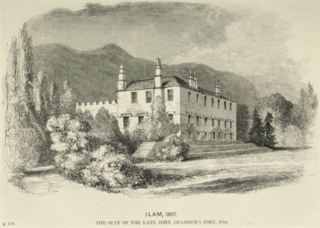
Ilam is a village in the Staffordshire Peak District of England, lying on the River Manifold. The population of the civil parish as taken at the 2011 census was 402.
Ilam Park is a 158-acre (0.64 km2) country park situated in Ilam, on both banks of the River Manifold five miles (8 km) north west of Ashbourne, England, and in the ownership of the National Trust. The property is managed as part of the Trust's White Peak Estate.
The White Peak Estate of the National Trust comprises several land holdings in the Southern Peak District, now referred to as Ilam Park, Dovedale and the White Peak in National Trust publications although administered from the "White Peak Estate Office". The holdings, totaling some 3,600 acres (1,500 ha), are managed from the estate office in Ilam and comprise:
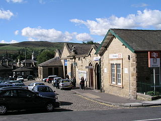
Glossop railway station serves the Peak District town of Glossop in Derbyshire, England. Glossop is the third busiest railway station in the county of Derbyshire after Derby and Chesterfield. It is located just north of Norfolk Square in the centre of Glossop.

Derwent was a village 'drowned' in 1944 when the Ladybower Reservoir in Derbyshire, England was created. The village of Ashopton, Derwent Woodlands church, and Derwent Hall were also 'drowned' in the construction of the reservoir.

The Youth Hostels Association is a charitable organisation, registered with the Charity Commission, providing youth hostel accommodation in England and Wales. It is a member of the Hostelling International federation.
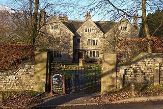
Hartington Hall is a much altered and extended 17th-century manor house at Hartington, Derbyshire, now a youth hostel.

Barrow House is a late 18th-century mansion situated on the eastern shore of Derwentwater in Borrowdale within the Lake District National Park, in the county of Cumbria, England. The house is a Grade II listed building which since the time of its construction has had various uses: it was originally a private dwelling and has since served as a hotel, a youth hostel run by the YHA, and was then an independent hostel until March 2024.

Cliffe Park Hall is a country house near Rudyard in Staffordshire, England. During its 200-year history, it has been a private residence, a golf club house and a youth hostel. The hall is a Grade II listed building.

Castleton Hall is an 18th-century grade II listed country hall on Castle Street in Castleton, Derbyshire.

Cryer House is a 17th-century grade II listed country hall on Castle Street in Castleton, Derbyshire.
The Castleton Medieval Hospital in Castleton, Derbyshire, consist of earthworks and buried remains of Castleton medieval hospital.

