Related Research Articles

Grant is an unincorporated community and a U.S. Post Office in Park County, Colorado, United States. The community is located in foothills of the Front Range in the Platte Canyon, in the upper valley of the North Fork South Platte River, approximately 6 miles (10 km) east of Kenosha Pass. It sits along U.S. Highway 285 approximately 40 miles (64 km) southwest of Denver. It consists largely of a retired general store, post office, and surrounding houses and trailers along the south side of the highway and along the north side of the river. The Grant Post Office has the ZIP Code 80448. Grant is located at the mouth of Geneva Creek where it descends southward from the Front Range. County Road 62 follows the creek northward to Guanella Pass, leading to Georgetown in the canyon of Clear Creek.
Sugar Creek is a 32.0-mile-long (51.5 km) tributary of the Susquehanna River in Bradford County, Pennsylvania in the United States.
Langdon Bay Creek is a creek in Mound, Minnesota, United States. It is the outflow for, and connects, Lake Langdon to Mound's Lost Lake, which is part of Lake Minnetonka. Its length is perhaps 200 feet (61 m) long and it runs west to east. It is unnavigable and passes under Commerce Boulevard through a culvert. It has also been known as Sollie's Creek, named after the uncles of the Andrews Sisters who owned a grocery store to the south of it.
Daugherty is an unincorporated community in Accomack County, Virginia, United States.
Ekalaka National Forest was established as the Ekalaka Forest Reserve in Montana on November 5, 1906 with 33,808 acres (136.82 km2). It became a National Forest on March 4, 1907. On July 1, 1908 it was absorbed by Sioux National Forest and the name was discontinued.

Jack Wade is an unincorporated community in Southeast Fairbanks Census Area, Alaska, United States. Its elevation is 2,428 feet (740 m), and it is located along Wade Creek at 64°9′15″N141°27′35″W, about 46 miles (74 km) south of Eagle near the Canada–US border. Founded as a mining camp around 1900, it was named for Jack Anderson and Wade Nelson, the original locators. Jack Wade received a post office in 1901, which remained until 1948.

Center Valley is a small unincorporated farming community in the town of Center in Outagamie County, Wisconsin, United States. Center Valley lies 5 miles (8.0 km) north of the City of Appleton, and is served by the post office of Black Creek, which has the ZIP code 54106.

Żychlin is a village in the administrative district of Gmina Potęgowo, within Słupsk County, Pomeranian Voivodeship, in northern Poland. It lies approximately 4 kilometres (2 mi) south-east of Potęgowo, 32 km (20 mi) east of Słupsk, and 73 km (45 mi) west of the regional capital Gdańsk.

Marten Beach is a hamlet in northern Alberta, Canada within the Municipal District of Lesser Slave River No. 124. It is located on the northeast shore of Lesser Slave Lake, 2 kilometres (1.2 mi) west of Highway 88. It is approximately 36 kilometres (22 mi) north of the Town of Slave Lake and 238 kilometres (148 mi) northwest of the City of Edmonton.

Irherm is a town in Taroudant Province, Souss-Massa, Morocco. According to the 2004 census it has a population of 4,624.
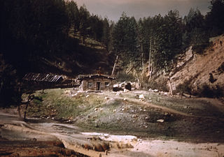
Since before the creation of Yellowstone National Park in 1872, entrepreneurs have established hotels and permanent tourist camps to accommodate visitors to the park. Today, Xanterra Parks and Resorts operates hotel and camping concessions in the park on behalf of the National Park Service. This is a list of hotels and permanent tourist camps that have operated or continue to operate in the park.
Slate Creek is a creek located in the Omineca Country region of British Columbia. This creek is a tributary of the Manson River and flows into that river from the west. Slate Creek was discovered in 1871. The creek has been mined using wing-damming and hand-mining.
Fremont Canyon is a stream and a deep valley or canyon that runs from its mouth at its confluence with Coyote Creek at the head of Fremont Wash in Iron County, Utah, eastward across the Tushar Mountains to its head at 38°05′05″N112°27′35″W on the west side of Fremont Pass in Garfield County, Utah.
Battle Creek is a stream in the U.S. state of South Dakota.
Louse Creek is a stream in the U.S. state of South Dakota.

Canillas is a ward (barrio) of Madrid belonging to the district of Hortaleza. it is also home to Parroquia de Santa Paula(Parish of Saint Paula.
Goose Creek is a stream in Caldwell County of Missouri. It is a tributary of Shoal Creek.
Nile is an unincorporated community in eastern Texas County, in the U.S. state of Missouri. The community is situated on the floodplain of Big Creek, approximately one mile west of the Texas-Shannon county line. The old Nile Schoolhouse was about one mile east (upstream) and on the opposite side of the river across a stream ford.
Neelby is an unincorporated community within the Rural Municipality of Kingsley No. 124, Saskatchewan, Canada. The community is located 2.5 km south and west of the town of Kippling on Township Road 133,. Very little remains of the community. Only two grain elevators and a few acreages remain.
Boggs Creek is a stream in the U.S. state of Georgia. It is a tributary to the Chestatee River.
References
- ↑ N.L. Barlee (1980), The Guide to Gold Panning, Revised Second Edition, Second Printing. Canada West Publications., ISBN 0-920164-04-8