Joshua Tree is a census-designated place (CDP) in San Bernardino County, California, United States. The population was 7,414 at the 2010 census. At approximately 2,700 feet above sea level, Joshua Tree and its surrounding communities are located in the High Desert of California. The center of the business district in Joshua Tree is on California State Route 62.

Yucca brevifolia is a plant species belonging to the genus Yucca. It is tree-like in habit, which is reflected in its common names: Joshua tree, yucca palm, tree yucca, and palm tree yucca.
Zabriskie Point is a part of the Amargosa Range located east of Death Valley in Death Valley National Park in California, United States, noted for its erosional landscape. It is composed of sediments from Furnace Creek Lake, which dried up 5 million years ago—long before Death Valley came into existence.
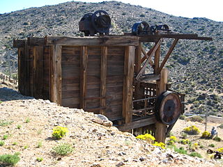
Johnny Lang was an American cattle driver who discovered Lost Horse Mine in Joshua Tree National Park. He claimed that he had moved to the area because his brother had been gunned down in New Mexico with six other cowboys. In 1890, in the process of herding their cattle, they lost their horses in what is now known as Lost Horse Valley. He tracked them to what is now known as Keys Desert Queen Ranch, which at that time was believed to be occupied by cattle rustlers from what known as the McHaney Gang, but did not find the horses. He then claimed he then met "Dutch" Frank, who claimed he discovered a rich gold claim but was afraid to develop it because he had been threatened by the purported rustlers. Lang and his father bought the rights to the mine, purportedly for $1,000.00, and named it "Lost Horse". He claimed to have taken on three partners as back-up, out of fear of the gang of purported rustlers or having his claim jumped. The four men filed their claim, set up a two-stamp mill and began to produce substantial amounts of gold. Lang's claim and mill were then sold to a Montana rancher named J.D. Ryan. Much of this history was provided by longtime Joshua Tree area resident William F. Keys, for whom Keys Ranch was named.
The Eagle Mountains are located in northeastern Riverside County, California, U.S.
The Mojave and Colorado Deserts Biosphere Reserve is a biosphere reserve designated by UNESCO in 1984 to promote the ecological conservation of a cluster of areas in the Mojave and Colorado deserts of California. A principal feature is Death Valley. The four management units encompassed by the reserve upon its creation were:

The Morongo Unified School District (MUSD) is a public education governing body in the Mojave high desert of Southern California. MUSD has more than 1,100 employees who provide educational services to 9,301 students.

Sunfair is an unincorporated community in the Mojave Desert, within San Bernardino County, California.

Devil's Punchbowl is a tilted sandstone formation on the northern slopes of the San Gabriel Mountains, in Los Angeles County, California, at an elevation of 4,750 feet (1,450 m).
Surprise Valley is located about seven miles east of Landers or three miles west of Sunfair Heights in San Bernardino County, California. It is north of Joshua Tree National Park. The valley is an areal feature.

Joshua Tree National Park is an American national park in southeastern California, east of Los Angeles and San Bernardino, near Palm Springs. It is named for the Joshua trees native to the Mojave Desert. Originally declared a national monument in 1936, Joshua Tree was redesignated as a national park in 1994 when the U.S. Congress passed the California Desert Protection Act. Encompassing a total of 790,636 acres – slightly larger than the state of Rhode Island – the park includes 429,690 acres of designated wilderness. Straddling San Bernardino and Riverside Counties, the park includes parts of two deserts, each an ecosystem whose characteristics are determined primarily by elevation: the higher Mojave Desert and the lower Colorado Desert. The Little San Bernardino Mountains traverse the southwest edge of the park.

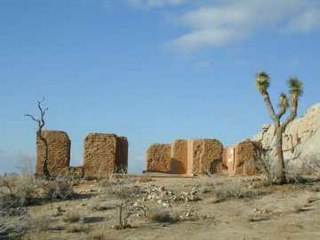
The Ryan House and Lost Horse Well are historic ruins in Joshua Tree National Park, California, United States. It was established by the family of J.D. Ryan, the later developers of the Lost Horse Mine, which became the most profitable mine in the area. The Lost Horse Well at the Ryan Ranch supplied water to the Lost Horse Mine, 3 miles (5 km) south and 750 feet (230 m), by pipeline.
The Twenty-Nine Palms Band of Mission Indians of California is a federally recognized tribe of Mission Indians with two reservations, one located near the cities of Indio and Coachella in Riverside County, and the other in the city of Twentynine Palms in San Bernardino County, California. While many scholars regard the tribe as being Luiseño, the tribe itself identifies as being Chemehuevi.

The Poachie Range is a moderate length mountain range and massif in southeast Mohave County, Arizona, and the extreme southwest corner of Yavapai County; the range also abuts the northeast corner of La Paz County. The Poachie Range massif is bordered by the south-flowing Big Sandy River on its west, and the west-flowing Santa Maria River on its south; both rivers converge at the Poachie Range's southwest at Alamo Lake, the Alamo Lake State Park.
San Felipe Creek is a stream in Imperial and San Diego Counties of California. It arises in the Volcan Mountains of San Diego County 33°11′57″N116°37′35″W, and runs eastward, gathering the waters of most of the eastern slope of the mountains and desert of the county before it empties into the Salton Sea. It is probably the last remaining perennial natural desert stream in the Colorado Desert region. In 1974, the San Felipe Creek Area was designated as a National Natural Landmark by the National Park Service.

Ryan Mountain is a 5,456-foot-high (1,663 m) mountain in Joshua Tree National Park. The trail to the peak is a strenuous hike, ascending 1,050 feet (320 m) in 1.5 miles (2.4 km). Ryan Mountain is a popular attraction in the park, because it leads to panoramic views of Pinto Basin, Lost Horse Valley, Queen Valley, and Pleasant Valley. It is one of the locations in Joshua Tree that features abundant lichen populations. It is named after J.D. Ryan, a wealthy rancher and early mining operator in the park.
J.D. Ryan was a Montana rancher and pioneer mining operator in Joshua Tree National Park. The popular park destination Ryan Mountain is named after him.

Lost Horse Mine is a historic gold and silver mine in the Lost Horse Valley of Joshua Tree National Park. Between 1894 and 1931, it produced 10,000 ounces of gold and 16,000 ounces of silver. It was first developed by Johnny Lang, then by J.D. Ryan. Scarce resources for steam powered pumps and mining equipment, led to denuding the local mountains of trees, which is still clearly visible in 2014.

Lost Palms Oasis Trail is a 7.2 mile day-hike trail located in the southernmost part of Joshua Tree National Park. The trail is generally completed in a loop. Known for the beautiful palm trees from which the trail gets its name, this hike is also known for its great bouldering, pools of water, and the ever-elusive "Victory Palms". Deemed by the National Park Service as a "Day-Use-Only" area, this trail is also home to bighorn sheep who use the pools as their main source of water.

Hidden Valley is a self-guiding, one-mile loop trail that winds among massive boulders through what was believed to be a legendary cattle rustlers' hideout. It is one of the most popular and scenic hiking trails in Joshua Tree National Park. The area is also a popular rock-climbing area. Many visitors enjoy just watching the climbers in action.


