
Tiger Bay was the local name for an area of Cardiff which covered Butetown and Cardiff Docks. Following the building of the Cardiff Barrage, which dams the tidal rivers, Ely and Taff, to create a body of water, it is referred to as Cardiff Bay. Tiger Bay is Wales’ oldest multi-ethnic community, with sailors and workers from over 50 countries settling there from the mid-19th century onwards.

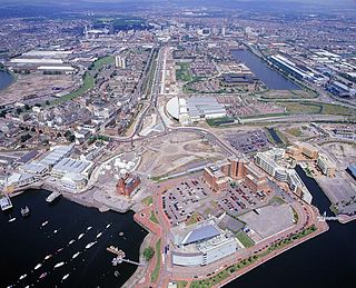
Cardiff Bay is an area and freshwater lake in Cardiff, Wales. The site of a former tidal bay and estuary, it is the river mouth of the River Taff and Ely. The body of water was converted into a 500-acre (2.0 km2) lake as part of a UK Government redevelopment project, involving the damming of the rivers by the Cardiff Bay Barrage in 1999. The barrage impounds the rivers from the Severn Estuary, providing flood defence and the creation of a permanent non-tidal high water lake with limited access to the sea, serving as a core feature of the redevelopment of the area in the 1990s.

Butetown is a district and community in the south of the city of Cardiff, the capital of Wales. It was originally a model housing estate built in the early 19th century by the 2nd Marquess of Bute, for whose title the area was named.
Adamsdown is an inner city area and community in the south of Cardiff, the capital city of Wales. Adamsdown is generally located between Newport Road, to the north and the mainline railway to the south. The area includes Cardiff Prison, Cardiff Magistrates' Court, Cardiff Royal Infirmary, a University of South Wales campus, and many streets of residential housing. There are two primary schools in the area Adamsdown Primary School and Tredegarville Primary School.

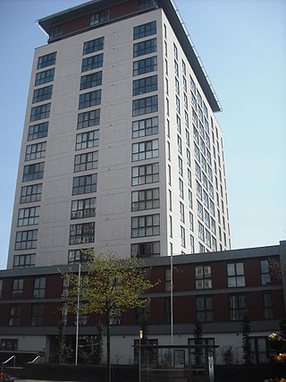
Atlantic Wharf is a southern area of the city of Cardiff, Wales. It is primarily an area of new houses and apartments located on the west side of the disused Bute East Dock and to the east of Lloyd George Avenue. It also includes a number of refurbished dock warehouses, modern hotels, the Red Dragon Centre and Cardiff Council's County Hall. Atlantic Wharf lies in the Butetown electoral division of Cardiff and the Cardiff South and Penarth constituency for the UK Parliament and the Senedd.

Cardiff city centre is the city centre and central business district of Cardiff, Wales. The area is tightly bound by the River Taff to the west, the Civic Centre to the north and railway lines and two railway stations – Central and Queen Street – to the south and east respectively. Cardiff became a city in 1905.

The Butetown branch line, also known as the Cardiff Bay Line, is a 1-mile-6-chain (1.7 km) commuter railway line in Cardiff, Wales from Cardiff Bay to Cardiff Queen Street. The service pattern used to comprise a mixture of shuttle services along the branch and through trains along the Rhymney Line to Caerphilly, or the Coryton Line to Coryton, but since December 2005 is a shuttle service from Queen Street station. The normal journey time is four minutes.

The Coal Exchange is a historic building in Cardiff, Wales. It is designed in Renaissance Revival style. Built in 1888 as the Coal and Shipping Exchange to be used as a market floor and office building for trading in coal in Cardiff, it later became a hub of the global coal trade. It is situated in Mount Stuart Square in Butetown, and was for many years the hub of the city's prosperous shipping industry.

Cardiff Bay railway station, formerly Cardiff Bute Road, is a station serving the Cardiff Bay and Butetown areas of Cardiff, Wales. It is the southern terminus of the Butetown branch line 1 mile (1.5 km) south of Cardiff Queen Street.

Bute Street is a street in Cardiff, Wales. It links Cardiff Bay and Butetown with Cardiff city centre. It now has no road number. It runs from the dockside of the Mermaid Quay complex in the south, which is now a pedestrian zone, to the junction of Bute Terrace (A4160) in the north.
Lloyd George Avenue, originally known as Bute Avenue, is an avenue in Cardiff, Wales. Roughly one mile long, the road links the Inner Harbour of Cardiff Bay to Cardiff city centre and forms part of the A470 road. It runs parallel to Bute Street and the Butetown Branch Line. Landscaping on the route was completed in 2000, and it was renamed after the Liberal prime minister David Lloyd George. The site of the avenue had been known as Collingdon Road, which was described as a "grimy industrial area of small factories and workshops, employing hundreds of people".

Cardiff Docks is a port in southern Cardiff, Wales. At its peak, the port was one of the largest dock systems in the world with a total quayage of almost 7 mi (11 km). Once the main port for the export of South Wales coal, the Port of Cardiff remains active in the import and export of containers, steel, forest products and dry and liquid bulks.

Architecture in Cardiff, the capital city of Wales, dates from Norman times to the present day. Its urban fabric is largely Victorian and later, reflecting Cardiff's rise to prosperity as a major coal port in the 19th century. No single building style is associated with Cardiff, but the city centre retains several 19th and early 20th century shopping arcades.
There are many listed buildings in Cardiff Bay, part of Cardiff, capital city of Wales. A listed building is one considered to be of special architectural, historical or cultural significance, and has restrictions on amendments or demolition. Buildings are listed as either Grade I, II* and II buildings lists, with the Grade I being the most important.

The Royal Hamadryad Hospital was a seamen's hospital and later a psychiatric hospital in the docklands area of Cardiff, Wales. It had replaced a hospital ship, the former HMS Hamadryad, in 1905. After it closed in 2002 the site was redeveloped for residential use.

Mount Stuart Square is a residential and commercial square in Cardiff, Wales. It is located in the Butetown area of the city. Originally developed in the late 1800s as a residential location for nearby dock workers, it quickly became a centre for upscale residential properties which revolved around the main square. By 1900, commercial activity had taken its place, dominated by the Coal Exchange, which occupied the once open central space. The square contains a high concentration of listed buildings, which represent a range of architectural styles and some of Cardiff's finest examples of late 19th and early 20th century commercial architecture. Mount Stuart Square area was designated a Conservation Area in July 1980.
Butetown, formerly Loudoun Square, is a planned station in Cardiff on the Butetown branch line. It is included within the Wales & Borders franchise and will be part of the South Wales Metro.


