Lough Derravaragh

Last updated

Lough Derravaragh
Knockeyon Deravaragh 07 08 2007.jpg
Lake from the summit of Knockeyon hill
Ireland relief location map.png
Red pog.svg
Lough Derravaragh
Location County Westmeath
Coordinates 53°38′0″N7°21′0″W / 53.63333°N 7.35000°W / 53.63333; -7.35000 Coordinates: 53°38′0″N7°21′0″W / 53.63333°N 7.35000°W / 53.63333; -7.35000
Native nameLoch Dairbhreach  (Irish)
EtymologyIrish loch dairbrech, "lake of oaks"
Primary inflows River Inny
Primary outflows River Inny
Catchment area 559.23 km2 (215.92 sq mi)
Basin  countries Ireland
Max. length10 km (6.2 mi)
Max. width4 km (2.5 mi)
Surface area9.14 km2 (3.53 sq mi; 2,260 acres)
Max. depth23 m (75 ft)
Surface elevation61 m (200 ft)
References [1] [2]
Designated7 June 1996
Reference no.847 [3]
Lake with Knockeyon hill to the right Knockeyon 07.jpg
Lake with Knockeyon hill to the right

Lough Derravaragh (Irish : Loch Dairbhreach) is a lake in County Westmeath, Ireland, north of Mullingar between Castlepollard, Crookedwood and Multyfarnham.

Contents

Lough Derravaragh sits on the River Inny which flows from Lough Sheelin on its way to the River Shannon. It is a popular lake for angling and other watersports.

History

There are ringforts to the east of Lough Derravaragh, within the hills of Ranaghan.

Turgesius the Viking, renowned for taking Dublin, also possessed strongholds nearby, southwest of Lough Lene.

Knockeyon, the hill of Saint Eyon, is located on the south-eastern shore of the lough, rising steeply to 215 metres. Halfway up the hill are the ruins of the ancient Saint Cauragh chapel, built and dedicated to Saint Eyon. The ruins of Saint Cauragh's Well are adjacent to the chapel.

On the Kiltoom side of the lough mounds of stone can be found, these were part of artificial islands and gave protection to the people who lived in crannógs on these islands. In the 1970s a dug-out canoe from the Stone Age was recovered from the lake by employees of the Tullynally estate.

Legends

Children of Lír

Lough Derravaragh is best known for its connection with the Irish legend of the Children of Lír . The legend relates how the four children of King Lír were turned into swans by their jealous stepmother and spent 300 years on Lough Derravaragh before moving to the Straits of Moyle (between Ireland and Scotland) for 300 years, and then spent 300 more years on the Atlantic Ocean by Erris and Inishglora.

Saint Cauragh

Legend tells that Saint Cauragh was expelled by Saint Columcille from the Kells monastery, for breach of discipline. Consequently, he wandered throughout the countryside until he eventually arrived at Knockeyon.

At this location, far away from the eyes of the world, Cauragh desired to pass the remainder of his life praying to God and fasting. He became seriously ill at a later stage, and was dying when he prayed to God for water to quench his thirst. Having prayed for some time, he became aware of the sound of water trickling out of the rock above his head. He put out his hand and drank freely of this miraculous water. He was cured as a result, and then he built the chapel.

During the Middle Ages, thousands of people visited this well on the first Sunday of harvest, undertaking the pilgrimage up the hill barefoot on what became known as Cauragh Sunday. When the pilgrimage concluded, everyone present adjourned to a green area at the foot of the hill where musicians played and everyone spent the remainder of the day picnicking, drinking and dancing.

Protected areas

Swans on the lake Glengad pictures August 2010 014.jpg
Swans on the lake

Lough Derravaragh is north of Mullingar and is part of the Lough Derravaragh Natural Heritage Area. [4] Most of this area comprises the lake, but also it includes a variety of wetland, grassland, and woodland habitats. The site includes a small area of raised bog. The site is bound in the northwest by the River Inny.

The Inny, which is a major tributary of the River Shannon, flows into and from Lough Derravaragh on its northwest shore. On this side, the lake is wide and shallow and raised bog and cutover bog are found within the immediate surrounding area (cutover bog is bog where some peat has been harvested, leaving remaining peat behind). Lough Derravaragh is shallow and its water is "hard", meaning it is alkaline. There is only a small area of raised bog on the side, but formerly it comprised a very large bog complex which extended towards the northwest of the lake. Most of this area has now been cutover and large areas have been reclaimed for agriculture. The remaining area of bog has hummock/hollow complexes but no water pools. Conifers have been planted upon the high bog and a section of cutover. Cutover is found dispersed around the high bog areas and there is also a separate small area of old cutover south of this raised bog.

Much of the high bog possesses vegetation typical of an Irish Midland raised bog, with such species as ling heather ( Calluna vulgaris ) and hare's tail cottongrass ( Eriophorum vaginatum ). The hummock-forming bog moss, Sphagnum papillosum has been recorded situated around one third of the high bog as has the more scarce Sphagnum imbricatum. Overall, sphagnum covers around one-third of the high bog area. The centre of the bog is wet with stagnant water in places. The aquatic bog moss Sphagnum cuspidatum has been recorded in the hollows of the bog. There are dried-out channels of the bog which are colonised by algae, deergrass ( Trichophorum cespitosum ) and lichens. On the cutover on the southeast shore of the lake there are areas of downy birchy ( Betula pubescens ) woodland, with patches of gorse ( Ulex europaeus ).

A notable feature of Lough Derravaragh, as found at Lough Lene, are the range of stoneworts that occur within the lake. Eight species have been recorded here, several of which have a restricted range in Ireland. Fringing the lake's shores, a range of habitats has been created as a result of drainage of the River Inny. At the western side are extensive reed beds and swamps of downy birch and willows. Nearby, there is also freshwater marches vegetation dominated by sedges ( Carex spp.) and often tussock-forming grasses such as tufted hair-grass ( Deschampsia cespitosa ) and fescues ( Festuca spp.), with a flowering herbs including Bidens cernua , and trifid bur-marigold.

The lake shore is a mineral-rich substrate and several plant species of poor fen habitats occur in abundance, such as black bog rush Schoenus nigricans and long-stalked yellow-sedge Carlex lepidocarpa.

Lough Derravaragh is also a Special Protection Area (SPA) under the EU Bird Directive (EC/79/409). [2] Three species (Greenland white-fronted goose (Anser albifrons flavirostris), whooper swan (Cygnus cygnus), and golden plover (Pluvialis apricaria)) are listed on Annex I of the directive, [5] requiring special conservation measures concerning their habitat in order to ensure their survival and reproduction.

The rare Charophyte, Chara denundata, has been recorded in the area, while the Red List [6] species otter (Lutra lutra) and Irish hare (Lepus timidus hibernicus) have also been observed within the lake district of North Westmeath.

Water sports

The lake is used for canoeing and other water activities. As in Lough Ennell, Lough Owel, and Lough Lene, the lake acts as an important amenity for anglers, as it sustains a population of brown trout.

See also

Related Research Articles

Lough Corrib Lake in the west of Ireland

Lough Corrib is a lake in the west of Ireland. The River Corrib or Galway River connects the lake to the sea at Galway. It is the largest lake within the Republic of Ireland and the second largest on the island of Ireland. It covers 176 km² and lies mostly in County Galway with a small area of its northeast corner in County Mayo.

County Westmeath County in Ireland

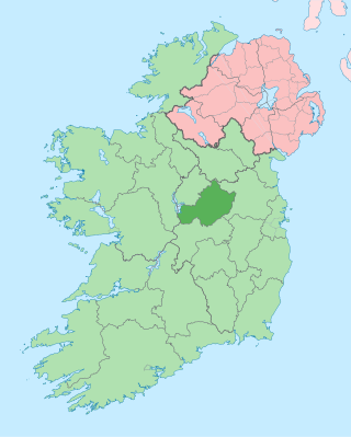
County Westmeath is a county in Ireland. It is in the province of Leinster and is part of the Midlands Region. It originally formed part of the historic Kingdom of Meath. It was named Mide because the kingdom was located in the geographical centre of Ireland. Westmeath County Council is the administrative body for the county, and the county town is Mullingar. At the 2016 census, the population of the county was 88,770.

<i>Sphagnum</i> Genus of mosses, peat moss

Sphagnum is a genus of approximately 380 accepted species of mosses, commonly known as "peat moss", although that term is also sometimes used for peat. Accumulations of Sphagnum can store water, since both living and dead plants can hold large quantities of water inside their cells; plants may hold 16 to 26 times as much water as their dry weight, depending on the species. The empty cells help retain water in drier conditions.

Castlepollard Village in Leinster, Republic of Ireland

Castlepollard is a village in north County Westmeath, Republic of Ireland. It lies west of Lough Lene and northeast of Lough Derravaragh and Mullingar.

Lough Gill

Lough Gill is a freshwater lough (lake) mainly situated in County Sligo, but partly in County Leitrim, in Ireland. Lough Gill provides the setting for William Butler Yeats' poem "The Lake Isle of Innisfree".

Ballynahone Bog is a raised bog, situated in County Londonderry, Northern Ireland, about 3 km south of Maghera, on low-lying ground immediately north of the Moyola River about 14 km from its mouth at Lough Neagh. It is one of the largest lowland raised bogs in Northern Ireland.

Lough Lene Lake in north County Westmeath, Ireland

Lough Lene is a lake situated in north County Westmeath, Ireland, between the villages of Castlepollard, Collinstown and Fore.

Knockeyon Hill in County Westmeath, Ireland

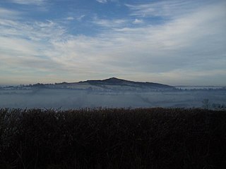
Knockeyon is a hill in County Westmeath, Ireland in the townland of Streamstown. When viewed from the Ranaghan, and Gillardstown side of the hill, it dominates the surrounding lakes in the countryside of northern County Westmeath. The chimney of the cement works in Duleek near Drogheda can be seen on a clear day due west, as well as Slieve Gullion in Co. Down and the Mourne Mountains beyond to the north east. The Hills of Mael, Curry and Mullaghmean are viewed from Knockeyon to the north west, and the Cuilcagh Mountains to the north-north-west.

Cors Caron

Cors Caron is a raised bog in Ceredigion, Wales. Cors is the Welsh word for "bog". Cors Caron covers an area of approximately 349 hectares. Cors Caron represents the most intact surviving example of a raised bog landscape in the United Kingdom. About 44 different species groups inhabit the area including various land and aquatic plants, fish, insects, crustaceans, lichen, fungi, terrestrial mammals and birds.

River Inny (Leinster) Tributary of the Shannon in central Ireland

The River Inny is a river within the Shannon River Basin in Ireland. It is 88.5 kilometres (55.0 mi) in length, and has a number of lakes along its course.

Lough Iron is a small lake on the River Inny, in County Westmeath, Ireland.

Tóin an tSeanbhaile Town in Connacht, Ireland

Tóin an tSeanbhaile is a small village located on the north east point of Achill Island, Ireland. It lies within the Mayo Gaeltacht.

Fore (barony, County Westmeath) Town in Leinster, Ireland

Fore is a barony in northern County Westmeath, Ireland. It was formed by 1672.

Tully Mountain (Ireland) Mountain in Ireland

Letter Hill is a large hill near the coast to the north-west of Letterfrack in County Galway, Ireland. It is 356 m (1,168 ft) high and been listed as a Special Area of Conservation.

Corkaree Barony in Leinster, Ireland

Corkaree is a barony in north County Westmeath, in the Republic of Ireland. It was formed by 1672. It is bordered by three other baronies: Fore, Moyashel and Magheradernon and Moygoish.

Moygoish Barony in Leinster, Ireland

Moygoish is a barony in north County Westmeath, in the Republic of Ireland, formed by 1672. It is bordered by County Longford to the west and four other Westmeath baronies: Corkaree, Fore, Moyashel and Magheradernon and Rathconrath to the south–west.

Clonava Townland in Leinster, Ireland

Clonava is a townland in County Westmeath, Ireland. It is located about 16.31 kilometres (10 mi) north of county town Mullingar.

Lough Kinale Lake on the River Inny, Ireland

Lough Kinale is a freshwater lake in the north midlands of Ireland. It is located on the borders of Counties Longford, Westmeath and Cavan. Lough Kinale forms part of the River Inny. The lake's inflow is from Lough Sheelin and the outflow is to Lough Derravaragh. The neighbouring Derragh Lough is also connected by a river to Lough Kinale.

Lough OFlynn Lake in County Roscommon, Ireland

Lough O'Flynn is a freshwater lake in the west of Ireland. It is located in west County Roscommon and is the source of the River Suck.

References

  1. "A Reference Based Typology and Ecological Assessment System for Irish Lakes" (PDF). Environmental Protection Agency (Ireland). 2006. p. 17. Retrieved 28 March 2020.
  2. 1 2 "Lough Derravaragh SPA". National Parks and Wildlife Service (Ireland) . Retrieved 28 March 2020.
  3. "Lough Derravaragh". Ramsar Sites Information Service. Retrieved 25 April 2018.
  4. "Lough Derravaragh NHA". National Parks and Wildlife Service (Ireland) . Retrieved 28 March 2020.
  5. European Commission (2010). "The Birds Directive" (PDF). Retrieved 7 June 2014.
  6. "Red Lists". National Parks and Wildlife Service. Retrieved 7 June 2014.