Hurstbourne is a home rule-class city in Jefferson County, Kentucky, United States. The population was 4,216 at the 2010 census, up from 3,884 at the time of the 2000 U.S. census. It is part of the Louisville Metro Government.

St. Matthews is a city in Jefferson County, Kentucky, United States. It forms part of the Louisville Metro government but is separately incorporated as a home rule-class city. The population was 17,472 at the 2010 census, up from 15,852 at the 2000 census. It is the 23rd-largest city in the state. St. Matthews is one of the state's major shopping areas, home to the fifth-largest mall in Kentucky along with many smaller shopping centers along Shelbyville Road.

Crescent Hill is a neighborhood four miles (6 km) east of downtown Louisville, Kentucky USA. This area was originally called "Beargrass" because it sits on a ridge between two forks of Beargrass Creek. The boundaries of Crescent Hill are N Ewing Ave to the St. Matthews city limit by Brownsboro Road to Lexington Road. Frankfort Avenue generally bisects the neighborhood.
Hayfield-Dundee is a neighborhood in eastern Louisville, Kentucky. Its boundaries are Dundee Road, Emerson Avenue, Newburg Road, I-264, and Tremont Drive to the east. Prior to subdivision, much of the land had been part of the Hayfield Farm, owned by Dr. Charles Wilkens Short, a founding professor of the University of Louisville medical school.
Poplar Level is a neighborhood five miles (8 km) southeast of downtown Louisville, Kentucky, United States. It is part of the larger Camp Zachary Taylor area.
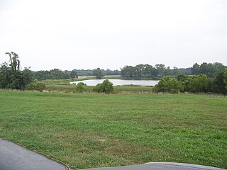
City of Parks is a municipal project to create a continuous paved pedestrian and biking trail around the city of Louisville, Kentucky while also adding a large amount of park land. The project was announced on February 22, 2005. Current plans call for making approximately 4,000 acres (1,600 ha) of the Floyds Fork floodplain in eastern Jefferson County into park space, expanding area in the Jefferson Memorial Forest, and adding riverfront land and wharfs along the Riverwalk Trail and Levee Trail. There are also plans to connect the 100-mile (160 km) Louisville trail to a planned seven mile (11 km) trail connecting the Southern Indiana cities of New Albany, Clarksville and Jeffersonville.

Bird's invasion of Kentucky was one phase of an extensive planned series of operations planned by the British in 1780 during the American Revolutionary War, whereby the entire West, from Quebec to the Gulf of Mexico, was to be swept clear of both Spanish and American forces. While Bird's campaign met with limited success, raiding two fortified settlements, it failed in its primary objective. Other British operations that were part of the plan also failed.
Griffytown is a neighborhood of Louisville, Kentucky established in 1879 in unincorporated Jefferson County, along Old Harrods Creek Road. Streets within its boundaries include: Bellewood Road, Robert Road, Church Lane, Lincoln Way, Cox Lane, Malcolm Avenue, Plainview Avenue and Booker Road. It has also been known as Griffeytown, and Griffithtown. It has a historical marker presented by African American Heritage Committee, Inc. of Louisville and Jefferson County.

Harrods Creek is a neighborhood of Louisville, Kentucky centered near Harrods Creek at the intersection of River Road and Wolf Pen Branch Road. It is roughly bordered by the Ohio River to the west and US 42 to the east. Its ZIP code is 40027. Formerly an unincorporated community, it was designated a neighborhood of Louisville when the city merged with Jefferson County in 2003.
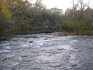
Beargrass Creek is the name given to several forks of a creek in Jefferson County, Kentucky. The Beargrass Creek watershed is one of the largest in the county, draining over 60 square miles (160 km2). It is fairly small, with an average discharge of 103 cubic feet per second at River Road in Louisville.
The Long Run massacre occurred on 13 September 1781 at the intersection of Floyd's Fork creek with Long Run Creek, along the Falls Trace, a trail in what is now eastern Jefferson County, Kentucky.

Louisville's fortifications for the American Civil War were designed to protect Louisville, Kentucky, as it was an important supply station for the Union's fight in the western theater of the war. They were typically named for fallen Union officers; usually those that served in the Army of the Ohio. The inspiration for building the forts came in October 1862, when Confederate forces engaged in their largest attack in Kentucky, only to be halted at the Battle of Perryville. Construction began in 1863, going at a slow pace until Confederate forces marched on Nashville, Tennessee, in the autumn of 1864. This caused General Hugh Ewing to demand from the city to force both military convicts and local "loafers" to help build the fortifications. Due to military engineers being needed on the front lines, the fortifications in Louisville were designed by civilian assistant engineers, as were the ones in Cincinnati, Ohio. Louisville was never endangered, so the guns never fired, save for salutes.

James John Floyd (1750–1783) was an early settler of St. Matthews, Kentucky, and helped lay out Louisville. In Kentucky he served as a Colonel of the Kentucky Militia in which he participated in raids with George Rogers Clark and later became one of the first judges of Kentucky.
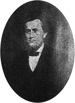
Alvin Wood (1831–1891) was an early settler in the area that is now the north central part of Jefferson County, Kentucky. He is credited with naming the community of Lyndon, Kentucky, in 1871. The Louisville and Nashville Railroad bordered his land, and Wood built a depot so travelers could catch the train without having to go to Gilman's Point, several miles away. Wood named the depot "Lyndon" for "Linn's Station," a pioneer fort on nearby Beargrass Creek, built in 1779. Wood affected a portion of the city of Louisville by setting in motion the events that led to the development of the area now known as Lyndon.
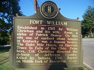
Fort William was a pioneer fort in Kentucky established in 1785 by Colonel William Christian and Anne Christian. William Christian directed the defense of what is now Louisville from attacks by the Indians. The fort was in the area of Jefferson County near St. Matthews and Lyndon. Although the historical marker for Fort William is located in front of the Eight Mile House, an early stone house and tavern, the location of the fort was actually southwest of the Eight Mile House. Fort William was another name for A'Sturgus Station built in 1779 on the Middle fork of Beargrass Creek. After Christian's death in 1786, his wife, Anne, began to refer to the site as Fort William. Anne Christian was a sister of Patrick Henry. The land acquired by the Christians was payment for his service during the Seven Years' War. They moved into the area with children and slaves. After William Christian's death, Anne moved to Mercer County. However, she was ill and traveled to the West Indies in hopes it would improve her health. In 1790, she died either on the return trip from Antigua or the day after arriving in Norfolk, Virginia.
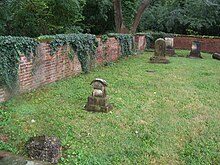
Floyd's Station was a fort on Beargrass Creek in what is now St. Matthews, Kentucky. In November 1779 James John Floyd built cabins and a stockade near what is now Breckenridge Lane. In 1783, John Floyd, future Governor of Virginia was born in the Station. The pioneer's father was killed by Indians twelve days before the birth of his son. The station was one of six on Beargrass Creek and was involved in local conflict with Native Americans in the area for the next five years. All that remain today of Floyd's Station are a spring house and cemetery.
Springs Station was a fort, established in 1780 in the area of Beal's Branch of Beargrass Creek in what is now Louisville, Kentucky. It was established at the time of the founding of Louisville as part of the settlement's defensive network of six forts, to protect settlers from attack by the Indians who were allied with the British.
Big Spring Country Club is a country club located in Louisville Metro. Prior to the 2003 city-county merger, the club's location was in an unincorporated part of Jefferson County, Kentucky, bordered by Louisville and St. Matthews. The club borders the Middle Fork of Beargrass Creek and the site of Floyd's Station, a fort built by John Floyd in 1779. It was named Big Spring because of a "big spring" which once furnished water for pioneer settlers in the area. This spring, located just below the 13th green of the golf course, is still flowing today.

Squire Boone's Station, also known as Painted Stone Station, was an 18th-century settlement in Kentucky in the United States. It was established in late 1779 or in the spring of 1780 by Squire Boone, Daniel Boone's pioneer brother, on the Clear Fork of Brashear's Creek 2 miles (3.2 km) north of present-day Shelbyville. Its alternate name came from the creekside rock painted with Boone's name and the date of his visit in 1776 when he was first scouting and claiming the area. Squire Boone's Station was the first large settlement in present-day Shelby County and counted Capt. Robert Tyler among its residents.

The Westervelt massacre, also known as the Westerfield massacre, was an attack by Native Americans on a caravan of Dutch American settlers on June 27, 1780, near the frontier. Occurring amidst the backdrop of the Revolutionary War, the attack remains one of the largest massacres in the history of Kentucky.