
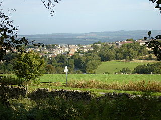
Annfield Plain is a village in County Durham, in England. It is situated on a plateau between the towns of Stanley, 3 mi (4.8 km) to the north-east, and Consett, 5 mi (8.0 km) to the west. According to the 2001 census, Annfield Plain had a population of 3,569. By the time of the 2011 Census Annfield Plain had become a ward of Stanley parish. The ward had a population of 7,774. Along with much of the surrounding area, Annfield Plain's history was coal mining.

Stanley is a town and civil parish in the ceremonial county and district of County Durham, England. Centred on a hilltop between Chester-le-Street and Consett, Stanley lies south-west of Gateshead.

Cornsay is a hamlet and civil parish in County Durham, England. The population of the Civil Parish taken at the 2011 census was 1,128. It is 6 miles (9.7 km) southeast of Consett and 7 miles (11 km) southwest of Durham. It consists of nineteen dwellings, including four farms & is the home of Greenacres nudist club. All formerly belonged to Ushaw College for the training of Catholic priests, hence the organised nomenclature. East and West Farms are now in private hands as homes but the other two are still active, South Farm run by the Suddes family and North Farm by the Tweddle family.

Waskerley is a village in County Durham, England. It is situated six miles to the southwest of Consett and three miles southwest of Castleside and the A68. Stanhope in the Durham Dales is a further six miles to the southwest and the Derwent Reservoir and the village of Edmundbyers is approximately five miles to the north. The village of Muggleswick is three miles to the north.
Bridgehill is an area of Consett in County Durham, England. It is situated near Benfieldside, Blackhill, Shotley Grove, and the River Derwent.
Burnopfield is a village in County Durham, in England. It is situated north of Stanley and Annfield Plain, close to the River Derwent and is 564 feet above sea level. There are around 4,553 inhabitants in Burnopfield. It is located 7 miles from Newcastle upon Tyne and 15 miles from Durham.

Dipton is a village located in County Durham, England. It is situated to the north-east of Consett, 3 miles south west of Burnopfield and a short distance to the north-west of Annfield Plain.
Castleside is a village in County Durham, England. It is situated a short distance to the south-west of Consett. Castleside is covered by the civil parish of Healeyfield.The village centre is located on the main A68 road which runs between Edinburgh and Darlington and the village crossroads allow easy access to Consett, the North Pennines and Stanhope. To the northeast lie other small villages called Moorside and The Grove.

Iveston is a village in County Durham, England. It is situated a short distance to the east of Consett. Housing in the area consists of a mixture of traditional cottages and large, newer residential properties. Historically, farming and mining formed the chief sources of employment in the village. In 1931 the parish had a population of 6395.

High Friarside is a village in County Durham, England classified as a suburban area. It is situated a short distance to the west of Burnopfield.

High Westwood is an English village in County Durham, a few miles to the north of Consett, near Ebchester and Hamsterley. It once had a colliery and coke works.
Ebchester is a village in County Durham, England. It is situated to the north of Consett and to the south east of Whittonstall and the hamlet of Newlands. The village sits at the intersection of the A694, which runs from Consett to Swalwell, and the B6309, which connects the A696 north of Belsay and runs through Whittonstall and Newlands, across the River Derwent, up Chare Bank then through Ebchester itself then past Medomsley into the A691 immediately south of the village of Leadgate.
Medomsley is a village in County Durham, England. It is about 2 miles (3 km) northeast of the centre of Consett, 1+1⁄2 miles (2 km) south of Hamsterley and 1 mile (2 km) southeast of Ebchester along the B6309. Leadgate lies a further mile to the south east.

Hamsterley is a village in County Durham, England. It is situated to the north of Consett and borders the hamlet of Low Westwood.

Langley Moor is an old pit village in County Durham, England. It is located approximately 2 miles south-west of Durham City. Langley Moor is within the civil parish of Brandon and Byshottles which is itself within the City of Durham constituency, as of 2019 represented by Mary Foy MP.
Rowlands Gill is a village on the north bank of the River Derwent, in the Metropolitan Borough of Gateshead, Tyne and Wear, England. The Gibside Estate is near the town.
Wideopen, also occasionally misspelled as Wide Open, is a village in the North Tyneside metropolitan borough of Tyne and Wear, England, around 5 miles (8.0 km) north of Newcastle.

Chopwell is a village in the Gateshead district, in the county of Tyne and Wear, England, 3 miles (4.8 km) west of Rowlands Gill and 1 mile (1.6 km) north of Hamsterley. At the 2011 Census, it had a population of 9,395.
Derwenthaugh Coke Works was a coking plant on the River Derwent near Swalwell in Gateshead. The works were built in 1928 on the site of the Crowley's Iron Works, which had at one time been the largest iron works in Europe. The coke works was closed and demolished in the late 1980s, and replaced by Derwenthaugh Park.
