Lower City Mills

Last updated

Lower City Mills
Lower City Mills, Perth - geograph.org.uk - 12129.jpg
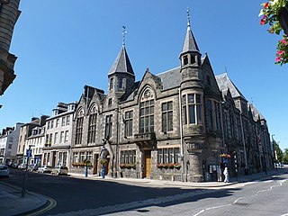
The entrance on Mill Wynd in 2005. Part of Upper City Mills is visible on the left
Location map Scotland Perth.png
Red pog.svg
Location within Perth
Coordinates 56°23′51″N3°26′08″W / 56.397401°N 3.435559°W / 56.397401; -3.435559
Construction
Completed1715(309 years ago) (1715)
Renovated
  • 1:circa 1805
Water Power
Diameter / width of water wheel4.7 m / 3.7 m
Equipment
Mule Frames
Listed Building – Grade A
Official nameLower City Mills
Designated20 May 1965 [1]
Reference no. 39578

Lower City Mills is part of a cluster of former watermill buildings, collectively known as City Mills, [2] in Perth, Scotland. It was given Category A listed status in 1965 by Scotland's Ancient Monument Division (now Historic Environment Scotland). [3] Milling has taken place at the location since the 14th century.

Contents

Upper City Mills is at the same location, on West Mill Street, and they processed wheat, oats, barley and peas and incorporated beer production and bread made from some these milled ingredients. [4]

The "whole rights and privileges" of the mills were gifted by charter of King Robert II in 1375. [5]

Perth Lade running beneath the mill building The Lower City Mills, Perth.jpg
Perth Lade running beneath the mill building

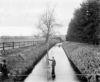
Initially there were two buildings on the site, on either side of Perth Lade, whose water powered the mills' wheels. [6] Each had its own water wheel. The one in the North building was dedicated to grinding oats, while the one in the South building produced pot barley and oats. These were consolidated into a single one in the centre of the building, measuring 3.7 metres in width and 4.7 metres in diameter. [4]

A map, drawn by military engineer Lewis Petit des Etans, dating from 1715 shows a mill at this site. Lower City Mills has had several rebuilds over the centuries. A fire in 1803 resulted in both buildings being rebuilt to a design by millwright John Stewart. It was he who reduced the number of wheels from two to one. [4] The buildings in view today were reconstructed around 1805, when the city was in the midst of a milling boom. [4]

In 1807, a study found that the mills were worked by four waterfalls, totalling about thirteen feet from the upper mill to the lower mill. The volume of water in the lade in October of that year was 3,180 cubic feet, and the calculations suggested that, if properly harnessed, this would product the equivalent of a 60-horsepower steam engine. [7]

James Macdonald & Son Grain Merchants and Millers were based at the mills in the early 20th century. Its offices were at 52 South Methven Street. [8]

In 1938, the production of barley was stopped, and its machinery removed to make space for the storage of oats. This refurbishment also introduced an early electrical motor to drive an automatic oat-drying kiln. This allowed the water wheel to focus its power on sifting, dressing and grinding oats until 1953, when business started to slow. The demand for oatmeal was falling with the rise in popularity of British-grown wheat for bread, as well as the competition from larger, more modern, producers, who could perform the same procedure at reduced cost and more efficiently. [4]

Two further electric motors were installed in an attempt to halt the mill's decline, but production ceased in 1966. [4]

In the 1980s, Perth and Kinross District Council, with the support of The Gannochy Trust, amongst others, oversaw a complete overhaul of the mill. [4]

During the late 1980s and through the 1990s, it produced mainly wheat flour for a local bakery, and along with the building's accommodation of new craft workshops and a tearoom, it became a tourist attraction. [4]

In 2001 it became the home of Perth Visitor Information Centre and the Perthshire Tourist Board, and then VisitScotland until June 2019. [4]

The structure has been on the Buildings at Risk Register since 2012, [3] but in November 2019, Perth and Kinross Heritage Trust assumed a caretaker role of the building as both office space and with a vision for a sustainable new future for the building. [4]

See also

Related Research Articles

<span class="mw-page-title-main">Perth, Scotland</span> City in central Scotland

Perth is a centrally located Scottish city, on the banks of the River Tay. It is the administrative centre of Perth and Kinross council area and is the historic county town of Perthshire. It had a population of about 47,430 in 2018.

<span class="mw-page-title-main">Porridge</span> Food

Porridge is a food made by heating or boiling ground, crushed or chopped starchy plants, typically grain, in milk or water. It is often cooked or served with added flavourings such as sugar, honey, fruit, or syrup to make a sweet cereal, or it can be mixed with spices, meat, or vegetables to make a savoury dish. It is usually served hot in a bowl, depending on its consistency. Oat porridge, or oatmeal, is one of the most common types of porridge. Gruel is a thinner version of porridge and congee is a savoury variation of porridge of Asian origin.

<span class="mw-page-title-main">Dunster Working Watermill</span> Restored watermill in Dunster, England

Dunster Working Watermill is a restored 18th century watermill, situated on the River Avill, close to Gallox Bridge, in the grounds of Dunster Castle in Dunster, Somerset, England. It is a Grade II* listed building and within the Grade II* registered parkland of the castle.

<span class="mw-page-title-main">Tulloch, Perth and Kinross</span> Human settlement in Scotland

Tulloch, formerly known as Bleachfield, is a residential area of Perth, Scotland, approximately 1.5 miles (2.4 km) north-west of the city centre. Tulloch is the western part of the area that borders Hillyland.

<span class="mw-page-title-main">Perth Bridge</span> Bridge in Perth, Scotland

Perth Bridge is a toll-free bridge in the city of Perth, Scotland. A Category A listed structure, it spans the River Tay, connecting Perth, on the western side of the river, to Bridgend, on its eastern side, carrying both automotive and pedestrian traffic of West Bridge Street. An earlier bridge was demolished at the same location in 1621, and many unsuccessful attempts were made to replace it. A subscription was started by James VI and several noblemen to help with the construction cost, but the king's death in 1625 suspended the scheme and a series of ferryboats were instead used.

<span class="mw-page-title-main">Barry Mill</span> Category A listed watermill in Barry, Angus in eastern Scotland

Barry Mill is a working Category A listed watermill in Barry, Angus in eastern Scotland. It is owned and operated by the National Trust for Scotland as an educational tourist attraction. Situated in a secluded area beside the Barry Burn, the mill lies about half a mile north of the village of Barry, near the town of Carnoustie. It is a three floor building, containing a meal floor (basement), a milling floor and a top. A site for several mills since at least 1539, Barry Mill was commercially operational until 1984; it was then restored, and has been operated by the Trust since 1992. It was threatened with closure in March 2009, but has remained open due to local support, and the securing of external funding.

<span class="mw-page-title-main">Perth City Hall</span> City hall in Perth, Perth and Kinross, Scotland

Perth City Hall is a civic building in King Edward Street, Perth, Scotland. Built in 1914, it is a Category B listed building.

<span class="mw-page-title-main">Municipal Buildings, Perth</span> Municipal building in Perth, Scotland

The Municipal Buildings are a municipal facility at Nos. 1, 3 and 5 High Street, Perth, Scotland. The facility is a Category B listed building.

<span class="mw-page-title-main">Perth Lade</span> Ancient watercourse in Scotland

Perth Lade is an historic 4.5 mi (7.2 km)-long watercourse in Perth and Kinross, Scotland. Created in the 11th century or earlier, it has been used to power several watermills, such as those that functioned at Perth's Lower City Mills, which have existed since the 18th century. Over its course, at least nineteen industrial sites existed; today, the remains of nine of these can be seen, the rest lost to inner-city development and housing schemes of the 20th and 21st centuries. A footpath follows the majority of the lade's course.

<span class="mw-page-title-main">Bridgend, Perth and Kinross</span> Human settlement in Scotland

Bridgend is a village near Perth, Scotland, approximately 0.25 miles (0.40 km) east of the city centre, on the eastern banks of the River Tay. It is in Kinnoull parish. A settlement has existed here since at least the 16th century.

<span class="mw-page-title-main">Greyfriars Burial Ground</span> Cemetery in Perth, Scotland

Greyfriars Burial Ground is an historic cemetery in Perth, Scotland, dating to 1580. It is now Category A listed.

<span class="mw-page-title-main">Vennels of Perth</span> Small streets and footpaths in Perth, Scotland

The vennels of Perth are a collection of small medieval streets in the city of Perth, Scotland. Similar to York's Snickelways, vennels are a public right-of-way passageway between the gables of buildings which can, in effect, be a minor street. In Scotland, the term originated in royal burghs created in the twelfth century, the word deriving from the Old French word venelle meaning "alley" or "lane". Unlike a tenement entry to private property, known as a "close", a vennel was a public way leading from a typical high street to the open ground beyond the burgage plots. The Latin form is venella, related to the English word "funnel".

<span class="mw-page-title-main">Cunningham–Graham Close</span> Historic site in Perth and Kinross, Scotland

Cunningham–Graham Close is an historic building in the centre of Perth, Perth and Kinross, Scotland. Located at 13–17 High Street, it is a Category B listed building, built in 1699. It is the oldest continually inhabited building in the city, and one of the few remaining that pre-date the Georgian new town remodelling of the city centre.

<span class="mw-page-title-main">Tay Street</span> Prominent street in Perth, Scotland

Tay Street is a major thoroughfare, part of the A989, in the Scottish city of Perth, Perth and Kinross. Planned in 1806 and completed around 1885, it is named for the River Tay, Scotland's longest river, on the western banks of which it sits. The street runs from the confluence of West Bridge Street and Charlotte Street in the north to a roundabout at Marshall Place and Shore Road in the south. Three of the city's four bridges that cross the Tay do so in this stretch : Perth Bridge, Queen's Bridge and the single-track Tay Viaduct, carrying Perth and Dundee trains to and from Perth railway station, located 0.5 miles (0.80 km) to the north-west.

<span class="mw-page-title-main">A. K. Bell Library</span> County building in Perth, Scotland

The A. K. Bell Library is an historic building on York Place in Perth, Perth and Kinross, Scotland. The building was originally a hospital before becoming a municipal building and later a library. The central section of the building is Category A listed. The lodge to the estate, now removed from its original location, is Category B listed.

<span class="mw-page-title-main">1 West Bridge Street</span> Tollhouse in Perth, Perth and Kinross, Scotland, UK

1 West Bridge Street is an historic building in the Bridgend area of Perth, Scotland. A former tollbooth building, it is a Category C listed building dating to around 1800 and is located on the southern side of the eastern end of Perth Bridge. The part of the building that curved around onto Commercial Street has been demolished.

<span class="mw-page-title-main">High Street (Perth, Scotland)</span> Prominent street in Perth, Scotland

High Street is a street and the primary retail area of the Scottish city of Perth. Established in at least the 15th century, its central section has been both modernised and pedestrianised, while its two ends are mainly Victorian in terms of their composite buildings. It runs for about 0.5 miles (0.80 km), from Tay Street in the east to Caledonian Road in the west.

<span class="mw-page-title-main">Mill Street (Perth, Scotland)</span> Prominent street in Perth, Scotland

Mill Street is a prominent street in the city of Perth, Scotland. Established in at least the 18th century, it runs for about 0.25 miles (0.40 km), from Bridge Lane in the east South Methven Street in the west, passing through roughly two-thirds of the northern third of the city centre.

Watergate is a street in the city of Perth, Scotland. Along with Skinnergate, it is one of the oldest streets in the city. It runs for around 0.12 miles (0.19 km) from High Street in the north to South Street in the south. It runs parallel to Tay Street to the east and St John Street to the west. At South Street, the road becomes Speygate, the former site of Gowrie House.

References

  1. WEST MILL STREET, LOWER CITY MILLS, TOURIST INFORMATION CENTRE - Historic Environment Scotland
  2. "‘Historic month’ for Perth and Kinross Heritage Trust as they move headquarters to A-listed building" - The Courier , 1 November 2019
  3. 1 2 Lower City Mills: Corn Mill (Former), West Mill Street, Perth - Buildings at Risk Register, 16 March 2012
  4. 1 2 3 4 5 6 7 8 9 10 Lower City Mills - Perth and Kinross Heritage Trust
  5. The Tourist's Hand-book to Perth and Neighbourhood (1849), p. 38
  6. "Take a Hike: The Lade, Perth, Perth & Kinross" - The Courier , 20 April 2019
  7. Civic History of Perth from Medieval Times – Perth Civic Trust
  8. Leslie's directory for Perth and Kinross (1911), p. 7