Prairies are ecosystems considered part of the temperate grasslands, savannas, and shrublands biome by ecologists, based on similar temperate climates, moderate rainfall, and a composition of grasses, herbs, and shrubs, rather than trees, as the dominant vegetation type. Temperate grassland regions include the Pampas of Argentina, Brazil and Uruguay, and the steppe of Ukraine, Russia and Kazakhstan. Lands typically referred to as "prairie" tend to be in North America. The term encompasses the area referred to as the Interior Lowlands of Canada, the United States, and Mexico, which includes all of the Great Plains as well as the wetter, hillier land to the east.

The Herbert Hoover National Historic Site is a unit of the National Park System in West Branch, Iowa, United States. The buildings and grounds are managed by the National Park Service to commemorate the life of Herbert Hoover, the 31st president of the United States. The park was established in 1965, shortly after it was named a National Historic Landmark. It now encompasses 186.8 acres (75.6 ha).

Strong City is a city in Chase County, Kansas, United States. Originally known as Cottonwood Station, in 1881 it was renamed Strong City after William Barstow Strong, then vice-president and general manager, and later president of the Atchison, Topeka and Santa Fe Railway. As of the 2020 census, the population of the city was 386. It is located along U.S. Route 50 highway.

Malibu Creek State Park is a state park of California, United States, preserving the Malibu Creek canyon in the Santa Monica Mountains. The 8,215-acre (3,324 ha) park was established in 1974. Opened to the public in 1976, the park is also a component of Santa Monica Mountains National Recreation Area.

Tallgrass Prairie National Preserve is a United States National Preserve located in the Flint Hills region of Kansas, north of Strong City. The preserve protects a nationally significant example of the once vast tallgrass prairie ecosystem. Of the 400,000 square miles (1,000,000 km2) of tallgrass prairie that once covered the North American continent, less than 5% remains, primarily in the Flint Hills. Since 2009, the preserve has been home to the Tallgrass Prairie bison herd.

The Flint Hills, historically known as Bluestem Pastures or Blue Stem Hills, are a region of hills and prairies that lie mostly in eastern Kansas. It is named for the abundant residual flint eroded from the bedrock that lies near or at the surface. It consists of a band of hills extending from Marshall and Washington Counties in the north to Cowley County, Kansas and Kay and Osage Counties in Oklahoma in the south, to Geary and Shawnee Counties west to east. Oklahomans generally refer to the same geologic formation as the Osage Hills or "the Osage."

The Midewin National Tallgrass Prairie (MNTP) is a tallgrass prairie reserve and is preserved as United States National Grassland operated by the United States Forest Service. The first national tallgrass prairie ever designated in the U.S. and the largest conservation site in the Chicago Wilderness region, it is located on the site of the former Joliet Army Ammunition Plant between the towns of Elwood, Manhattan and Wilmington in northeastern Illinois. Since 2015, it has hosted a conservation herd of American bison to study their interaction with prairie restoration and conservation.
Homestead National Historical Park, a unit of the National Park System known as the Homestead National Monument of America prior to 2021, commemorates passage of the Homestead Act of 1862, which allowed any qualified person to claim up to 160 acres (0.65 km2) of federally owned land in exchange for five years of residence and the cultivation and improvement of the property. The Act eventually transferred 270,000,000 acres (1,100,000 km2) from public to private ownership.

The Joseph H. Williams Tallgrass Prairie Preserve, in Osage County, Oklahoma near Foraker, Oklahoma, is the largest protected tract of tallgrass prairie in the world. Managed by The Nature Conservancy, the preserve contains 39,650 acres (160 km2) owned by the Conservancy and another 6,000 acres (24 km2) leased in what was the original tallgrass region of the Great Plains that stretched from Texas to Manitoba.

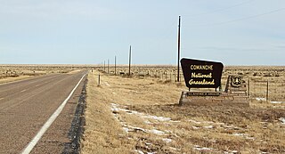
Comanche National Grassland is a National Grassland located in southeastern Colorado, United States. It is the sister grassland of Cimarron National Grassland and contains both prairie grasslands and canyons. It is separated into two sections, each operated by a local ranger district, one of which is in Springfield and the other of which is in La Junta. The grassland is administered by the Forest Service together with the Pike and San Isabel National Forests, and the Cimarron National Grassland, from common headquarters located in Pueblo, Colorado.
Pioneers Park Nature Center, established in 1963, is a 668-acre (2.70 km2) nature preserve located within Pioneers Park, which is located at the intersections of South Coddington and West Van Dorn Streets in Lincoln, Nebraska. Both Pioneers Park and the Nature Center within it are operated by the Lincoln Parks and Recreation Department.

The Geography of Oklahoma encompasses terrain and ecosystems ranging from arid plains to subtropical forests and mountains. Oklahoma contains 10 distinct ecological regions, more per square mile than in any other state by a wide margin. It is situated in the Great Plains and U.S. Interior Highlands region near the geographical center of the 48 contiguous states. Usually considered part of the South Central United States, Oklahoma is bounded on the east by Arkansas and Missouri, on the north by Kansas, on the northwest by Colorado, on the far west by New Mexico, and on the south and near-west by Texas.
Northern Tallgrass Prairie National Wildlife Refuge was established to provide a means of working with individuals, groups, private organizations, and government entities to permanently preserve a portion of the remaining remnant tracts of northern tallgrass prairie in Minnesota and Iowa. The United States Fish and Wildlife Service is acquiring remnant prairie tracts for the refuge in both easement and fee title interests from willing sellers.

Fishing Creek Schoolhouse is a historic school located in the Villas census-designated place, of Lower Township, Cape May County, New Jersey, United States. The schoolhouse was built in 1888 and added to the National Register of Historic Places on March 6, 1980.

Cedar Hill is a city in Dallas and Ellis counties in the U.S. state of Texas. It is located approximately 16 miles (26 km) southwest of downtown Dallas and is situated along the eastern shore of Joe Pool Lake and Cedar Hill State Park. Per the 2020 United States census, the population was 49,148. Cedar Hill is a suburb of the city of Dallas and is part of the Best Southwest area, which includes the nearby cities of DeSoto, Duncanville, and Lancaster.

The B. Harley Bradley House is a Frank Lloyd Wright-designed home, constructed in the Prairie School style, that was constructed in Kankakee, Illinois in 1900–1901.
The Tallgrass Prairie bison herd is a population of American bison inhabiting the Tallgrass Prairie National Preserve in central Kansas. It is a public bison herd that has little evidence of cattle introgression.

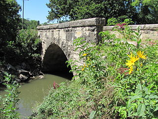
The Fox Creek Stone Arch Bridge is a historic bridge across Fox Creek northwest of Strong City in Chase County, Kansas. The bridge was built in 1898 by B. Landry and Sons, who contracted with the Chase County government to build it for $2,000. The company built the bridge using limestone from a local quarry and arranged it in a single stone arch. The bridge is 55 feet (17 m) long and 20 feet (6.1 m) wide. It has carried county road traffic since its opening and is also part of the Community Connection Trail, which links Strong City with Tallgrass Prairie National Preserve.


