Lower Hardres

Last updated

Lower Hardres
Lower Hardres War Memorial - geograph.org.uk - 1802452.jpg
War Memorial constructed by H G Browning to commemorate those who lost their lives in World War One
Kent UK location map.svg
Red pog.svg
Lower Hardres
Location within Kent
Area9.14 km2 (3.53 sq mi)
Population570 (Civil Parish 2011) [1]
  Density 62/km2 (160/sq mi)
OS grid reference TR150530
Civil parish
District
Shire county
Region
Country England
Sovereign state United Kingdom
Post town CANTERBURY
Postcode district CT4
Dialling code 01227
Police Kent
Fire Kent
Ambulance South East Coast
UK Parliament
List of places
UK
England
Kent
51°14′10″N1°04′48″E / 51.236°N 1.080°E / 51.236; 1.080

Lower Hardres is a village and former civil parish, now in the parish of Lower Hardres and Nackington, in the City of Canterbury district of Kent, England.

Contents

History

The name of the Hardres family is perpetuated in the twin villages of Upper Hardres and Lower Hardres (pronounced 'hards'), on the Roman road, Stone Street, south-west of the city of Canterbury. The family owned the non-church land of area for 700 years after the Norman Conquest. [2]

Middle ages

A legal record in 1381 mentions William Sely, parson of "parva Ardres", & may indicate that a bell at Lower Hardres church was being made or repaired by John Buckingham. A debt of 45 marks is mentioned. [3]

19th century

Lower Hardes was the village in which the first thresher was destroyed as part of the Swing Riots, on 28th August 1830. [4]

John Marius Wilson's Imperial Gazetteer of England and Wales described Lower Lardres as:

A parish in Bridge district, Kent; on Stane-street, 3 miles ESE of Chartham r. station, and 3¼ S of Canterbury. [5]

20th century

On the 1st of April 1934 the parish of Nackington was merged into "Lower Hardres", [6] on the 1st of April 2019 the new parish was renamed to "Lower Hardres and Nackington". [7] In 1931 the parish of Lower Hardres (prior to the merge) had a population of 254. [8]

Location

Lower Hardres consists of a branch of roads that stem mainly from Canterbury. The populated areas of Lower Hardres are situated on minor roads, these being; Hardres Ct Road, Bridge Road and Faucett Hill. The parish church, St. Mary's is located on the east edge of the village, however another St, Mary's church can be found in Nackington, north of Lower Hardres on Nackington Road on the B2068.

The Parish is engulfed in the countryside with fields bordering the area. The closest city is Canterbury around 5 kilometres North of the Parish.

The village

John Baker White memorial hall Lower Hardres Village hall - geograph.org.uk - 340706.jpg
John Baker White memorial hall

There are currently no schools in the village, however there are primary schools within a couple of miles at Petham, Bridge and Bossingham. Garlinge Green has the closest secondary school to Lower Hardres and is just on the outskirts of Canterbury. [9]

There are only a couple key buildings in the immediate area of the village. The village hall is situated within the center of the community and is more commonly known as the John Baker White Memorial Hall which was built in 1995. It has been awarded for its facilities and management, the hall itself is considered to be of rural nature on the outside, keeping in touch with the surroundings while boasting a more modern interior. It is home to a variety of local clubs, activities take place within the grounds and also different classes that are available for everyone. The hall can also be hired out as a venue for many different events. [10]

An Ordnance Survey road map of Lower Hardres and the surrounding areas in the 20th Century. A 20th Century map of Lower Hardres.png
An Ordnance Survey road map of Lower Hardres and the surrounding areas in the 20th Century.

The Lower Hardres & Nackington Gardeners' Society also occupies the hall and supports Kents MS therapy centre where they have a stall for the centre at shows and offer activities and refreshments [11]

There are a few different businesses scattered within the immediate area such as a pet store, hair salon, office supply shop and a sport shop specializing in maintenance of facilities and safety.

There are two farms being run from within the village, Butts Farm and Street End Farms. [12]

Historical Buildings

Another influential building within the community when considering historical value is St Mary's, the local parish church is located on the eastern edge of the village. The church is believed to have been constructed around 1831-2 by Richmond and Hutchinson in an early English style on a similar if not the exact location an earlier church had occupied until being demolished. It contains a single stained glass window facing the east, behind the altar. [13] The churchyard which occupied the land before the current

church contains headstones, as well as a small collection of chest tombs and oval bodystones.

Demography

Population

Census information from Vision of Britain and neighbourhood statistic has been combined to create a graph to show the total population in Lower Hardres. Lower Hardres population time series 1801-2011.jpg
Census information from Vision of Britain and neighbourhood statistic has been combined to create a graph to show the total population in Lower Hardres.

Statistics from the census dating back to 1801 at the earliest offers a foundation for determining population growth. From the data collected the population of Lower Hardres was found to be at 215 during 1801. Between the 1911 and 1921 census there had been a decrease in population which could be an impact of the first world war and conscription.

Occupation structure of the Lower hardres community concerning both males and females obtained from the 1881 census Occupation Structure.png
Occupation structure of the Lower hardres community concerning both males and females obtained from the 1881 census

The population fluctuated whilst still maintaining moderate growth until 1961. Recent Census results have shown a positive growth from 1961 to an increased population of 557 in 2001, and to 570 in 2011.

Occupation

The dominating sector from 1881 was agriculture with a high concentration of workers, predominantly male who could have been considered more appropriate for the type of work due to physical presence. There was also a high level of populace that had unknown occupations, also being only prominent with females, this may have been the cause of childbirth as a mother that worked to care for the family at home. Other professions such as authority lodging and animal care, were given considerably fewer workers.

Related Research Articles

<span class="mw-page-title-main">Ludgershall, Buckinghamshire</span> Human settlement in England

Ludgershall is a village and civil parish in the unitary authority area of Buckinghamshire, England. It is near the boundary with Oxfordshire, about 5.5 miles (9 km) south-east of Bicester and 5 miles (8 km) west of Waddesdon.

<span class="mw-page-title-main">City of Canterbury</span> Local government district in Kent, England

Canterbury, commonly called the City of Canterbury, is a local government district with city status in Kent, England. As well as Canterbury itself, the district extends north to the coastal towns of Whistable and Herne Bay.

<span class="mw-page-title-main">Chartham</span> Village and civil parish in Kent, England

Chartham is a village and civil parish in the Canterbury district of Kent, England. It is situated on the Ashford side of the city, and is in the North Downs area of Outstanding Natural Beauty, 2.3 mi (4 km) south west of Canterbury, England. The Great Stour Way path passes through the village. A paper mill in the village that had specialised in the production of tracing paper since 1938 has in 2022 closed down. There are numerous arable farms and orchards in the parish. The village has an unstaffed station, Chartham, and has recently upgraded its staffed level crossing to an automatic barrier. It has an outlying locality sharing in many of the community resources, Chartham Hatch. Its current Lord Mayor is Gary Dodd.

<span class="mw-page-title-main">Adisham</span> Human settlement in England

Adisham is a village and civil parish in the English county of Kent. It is twinned with Campagne-lès-Hesdin in France.

<span class="mw-page-title-main">Blean</span> Human settlement in England

Blean is a village and civil parish in the Canterbury district of Kent, England. The civil parish is large and is mostly woodland, much of which is ancient woodland. The developed village within the parish is scattered along the road between Canterbury and Whitstable, in the middle of the Forest of Blean. The parish of St. Cosmus and St. Damian in the Blean was renamed "Blean" on 1 April 2019.

<span class="mw-page-title-main">Ripple, Kent</span> Human settlement in England

Ripple, also known as 'Ripple Vale', is a village and civil parish in the Dover District of Kent, England.

<span class="mw-page-title-main">Barham, Kent</span> Human settlement in England

Barham is a village and civil parish in the City of Canterbury district of Kent, England. Barham village is approximately 6 miles (10 km) south-east from Canterbury and 8 miles (13 km) north from Folkestone.

<span class="mw-page-title-main">Sundridge with Ide Hill</span> Human settlement in England

Sundridge and Ide Hill is a civil parish in the Sevenoaks District of Kent, England. It is located in the Darenth valley and lies between Sevenoaks and Westerham. The parish contains the villages of Sundridge and Ide Hill and the hamlet of Goathurst Common. It lies within the Kent Downs Area of Outstanding Natural Beauty and within London’s Metropolitan Green Belt. It is approximately 21 miles south of London.

<span class="mw-page-title-main">Great Chart</span> Human settlement in England

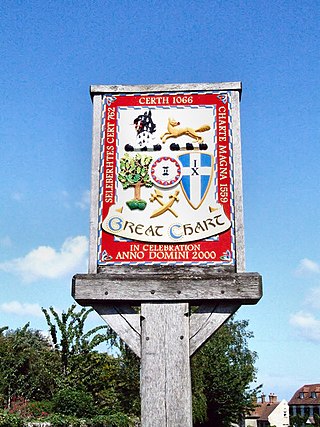
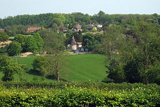
Great Chart is a village and former civil parish, now in the parish of Great Chart with Singleton, in the Ashford borough of Kent, England. The parish is split between the ancient village of Great Chart and the modern Singleton neighbourhood on the western outskirts of Ashford. The village centre of Great Chart is 2 miles (3.2 km) from the town centre. In 1961 the parish had a population of 969.

<span class="mw-page-title-main">Rolvenden</span> Village in Kent, England

Rolvenden is a village and civil parish in the Ashford District of Kent, England. The village is centred on the A28 Ashford to Hastings road, 5 miles (8.0 km) south-west of Tenterden.

<span class="mw-page-title-main">Upper Hardres</span> Human settlement in England

Upper Hardres is a village and civil parish in the City of Canterbury, in the district of Kent, England.

<span class="mw-page-title-main">Leaveland</span> Human settlement in England

Leaveland is a hamlet and civil parish located in the Swale borough of Kent, South East England. In terms of topography, it is described as a "village surrounded by inhabited countryside", and is situated mostly on high ground. It is located 5 miles South of Faversham, West of Badlesmere, and on or close to the A251.The closest railway station to the area is Selling, which is just over three miles away, although Faversham station is more accessible and offers better services. The closest estuary is The Swale which separates the Isle of Sheppey from mainland Kent, and flows to the north of Faversham Creek.. Leaveland itself covers an area of 1.5 km2 and lies entirely within the Kent Downs Area of Outstanding Natural Beauty.

<span class="mw-page-title-main">Hunton, Kent</span> Village and civil parish in Kent, England

Hunton is a civil parish and village near the town of Maidstone in Kent, England.

<span class="mw-page-title-main">Nackington</span> Human settlement in England

Nackington is an English village and former civil parish, now in the parish of Lower Hardres and Nackington, south of Canterbury in the Canterbury district, in the county of Kent. The 12th century church is dedicated to St Mary. In 1931 the parish had a population of 80.

<span class="mw-page-title-main">Pett Bottom (Canterbury)</span> Hamlet near Canterbury, Kent, England

Pett Bottom is a small settlement about five miles (8 km) south of Canterbury, Kent, England. The nearest village is Lower Hardres. It is in the civil parishes of Bishopsbourne and Lower Hardres and Nackington, both of which are in the City of Canterbury.

<span class="mw-page-title-main">Langdon, Kent</span> Human settlement in England

Langdon is a civil parish in the Dover district of Kent, England, and contains the villages of East Langdon and West Langdon, and the hamlets of Martin and Martin Mill. Langdon was the site of Langdon Abbey which was dissolved in 1535.

<span class="mw-page-title-main">Buttsbury</span> Village in Essex, England

Buttsbury is a village and former 2,079-acre (8.4 km2) civil parish now in the parish of Stock, in the Chelmsford district of Essex, England. Its name is a contraction of Botulph's Pirie, a major saint who died in 680. It is sometimes surmised that the name refers to a tree under which St Botolph preached. In 1931, the civil parish had a population of 1709.

<span class="mw-page-title-main">Goldington</span> Human settlement in England

Goldington is part of Bedford, Bedfordshire, England. It encompasses much of the historic village and parish of Goldington that was merged with Bedford in 1934, although some parts of the old village are within the neighbouring Newnham ward. It also includes two modern estates that are part of Renhold parish.

<span class="mw-page-title-main">Elmsted</span> Human settlement in England

Elmsted is a village and civil parish in the Folkestone and Hythe District of Kent, England. It is located west of Stone Street, the Roman road which today takes traffic between Canterbury and Lympne. Within the parish are the settlements of Bodsham, North Leigh and Evington. There are six elected members of the Parish Council.

<span class="mw-page-title-main">Norton, Buckland and Stone</span> Human settlement in England

Norton, Buckland and Stone is a small rural civil parish 1 mile (1.6 km) east of Teynham and 3 miles (4.8 km) west of the centre of Faversham in the borough of Swale, Kent, England. It is bypassed by the M2 to the south and traverses the historic A2, on the route of the Roman road of Watling Street.

References

  1. Key Statistics; Quick Statistics: Population Density Archived 11 February 2003 at the Wayback Machine United Kingdom Census 2011 Office for National Statistics Retrieved 21 November 2013
  2. Canterbury City Council
  3. National Archives; CP 40/483; http://aalt.law.uh.edu/AALT6/R2/CP40no483/483_0080.htm, second entry; John Buckingham, is a "clarioner"; year 1381
  4. Hobsbawm, Eric; Rudé, George (2014). Captain Swing. Verso Books.
  5. "History of Lower Hardres, in Canterbury and Kent | Map and description". www.visionofbritain.org.uk. Retrieved 28 March 2017.
  6. "Relationships and changes Lower Hardres CP/AP through time". A Vision of Britain through Time. Retrieved 15 May 2019.
  7. "The Canterbury City Council (Reorganisation of Community Governance) Order 2018" (PDF). Local Government Boundary Commission for England . Retrieved 15 May 2019.
  8. "Population statistics Lower Hardres CP/AP through time". A Vision of Britain through Time . Retrieved 14 June 2023.
  9. "Primary schools reviews for LowerHardres | School Guide". www.schoolguide.co.uk. Retrieved 1 May 2017.
  10. Hall, Lower Hardres Village. "Welcome to Lower Hardres Village Hall". www.lowerhardresvillagehall.org. Retrieved 1 May 2017.
  11. "Charity Stall at Lower Hardres and Nackington Gardeners Society's Autumn Show". Kent MS Therapy Centre. Retrieved 1 May 2017.
  12. "Lower Hardres Farm Shop". www.lowerhardresfarmshop.co.uk. Retrieved 1 May 2017.
  13. "St. Mary's, Lower Hardres - Canterbury DFAS". www.canterburydfas.org.uk. Retrieved 1 May 2017.[ permanent dead link ]

Commons-logo.svg Media related to Lower Hardres at Wikimedia Commons