
The Arctic Archipelago, also known as the Canadian Arctic Archipelago, groups together all islands lying to the north of the Canadian continental mainland excluding Greenland.
The Upper Derwent Valley is an area of the Peak District National Park in England. It largely lies in Derbyshire, but its north eastern area lies in Sheffield, South Yorkshire. Its most significant features are the Derwent Dams, Ladybower, Derwent and Howden, which form Ladybower Reservoir, Derwent Reservoir and Howden Reservoir respectively.
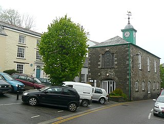
Camelford is a town and civil parish in north Cornwall, England, United Kingdom, situated in the River Camel valley northwest of Bodmin Moor. The town is approximately ten miles (16 km) north of Bodmin and is governed by Camelford Town Council. Lanteglos-by-Camelford is the ecclesiastical parish in which the town is situated. The ward population at the 2011 Census was 4,001. The Town population at the same census was 865 only

North Cornwall is an area of Cornwall, England, United Kingdom. It is also the name of a former local government district, which was administered from Bodmin and Wadebridge 50.516°N 4.835°W. Other towns in the area are Launceston, Bude, Padstow, and Camelford.

The River Eamont is a river in Cumbria, England and one of the major tributaries of the River Eden. The name of the river is from Old English (ēa-gemōt) and is a back formation from Eamont Bridge which means the junction of streams.

The Aralkum Desert is a desert that has appeared since 1960 on the seabed once occupied by the Aral Sea. It lies to the south and east of what remains of the Aral Sea in Uzbekistan and Kazakhstan.

The River Crane, a tributary of the River Thames, runs through part of west London, England, historically the former county of Middlesex. The Crane flows 8.5 miles (13.6 km) through three London boroughs: Hillingdon, Hounslow and Richmond upon Thames. The drainage basin is heavily urbanised but the immediate old flood-meadows of the Crane Valley are a main "river corridor" in London – a continuous belt of semi-natural habitat. In common with many urban rivers, the Crane's form has been greatly altered, in its case over centuries, by river engineering: widening, narrowing, straightening, dredging, supplementing, adding a discharge channel, and bank reinforcement.

South West Water provides drinking water and waste water services throughout Devon and Cornwall and in small areas of Dorset and Somerset. South West Water was created in 1989 with the privatisation of the water industry. It was preceded by the South West Water Authority which was formed by the Water Act 1973 as one of ten regional water authorities formed by a merger of various statutory and local authority water undertakings. South West Water is part of the Pennon Group.

Alcolea del Río is a municipality in Seville, Spain. In 2005, it had a population of about 3,331. It has an area of 50 square kilometers and population density of 66.6 people per square kilometer. It is situated at an altitude of 32 meters and is 53 kilometers from Seville.

Rough Tor, or Roughtor, is a tor on Bodmin Moor, Cornwall, United Kingdom. The site is composed of the tor summit and logan stone, a neolithic tor enclosure, a large number of Bronze Age hut circles, and some contemporary monuments.
SS Rosehill – also known as SS Penhill – was a 2,788-tonne steel-hulled collier built in 1911 by S.P. Austin and Son of Sunderland under the name Minster. She was torpedoed by the Imperial German Navy submarine UB-40 in the English Channel off Fowey, Cornwall, England, on 23 September 1917 while en route from Cardiff, Wales, to Devonport. She was taken under tow but sank in Whitsand Bay at 18:05. Her wreck lies in 28 metres of water at 50°19.793′N4°18.520′W with her bow to the north.

The Camelford water pollution incident involved the accidental contamination of the drinking water supply to the town of Camelford, Cornwall, in July 1988. Twenty tonnes of aluminium sulphate was inadvertently added to the water supply, raising the concentration to 3,000 times the admissible level. As the aluminium sulphate broke down it produced several tonnes of sulphuric acid which "stripped a cocktail of chemicals from the pipe networks as well as lead and copper piping in people's homes." Many people who came into contact with the contaminated water experienced a range of short-term health effects, and many victims suffered long-term effects whose implications remained unclear as of 2012. There has been no rigorous examination or monitoring of the health of the victims since the incident, which is Britain's worst mass poisoning event. Inquests on people who died many years later found very high levels of aluminium in the brain. Dame Barbara Clayton led a Royal Commission on Environmental Pollution enquiry into the incident.
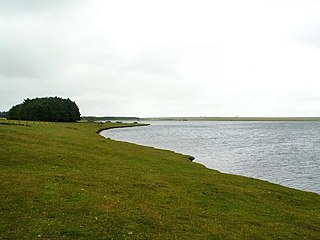
Crowdy Reservoir is located on Bodmin Moor near Camelford in north Cornwall. It is currently managed, jointly by the South West Lakes Trust and South West Water. There is public access to the reservoir away from the nature reserve. The reservoir supplies water to the North Cornwall water distribution network via treatment at the Lowermoor Water Treatment Works.

The River Ottery is a small river in northeast Cornwall, United Kingdom. The river is about twenty miles (32 km) long from its source southeast of Otterham to its confluence with the River Tamar at Nether Bridge, two miles (3.2 km) northeast of Launceston.
A regional water authority, commonly known as a water board, was one of a group of public bodies that came into existence in England and Wales in April 1974, as a result of the passing of the Water Act 1973. This brought together in ten regional units a diverse range of bodies involved in water treatment and supply, sewage disposal, land drainage, river pollution and fisheries. They lasted until 1989, when the water industry was privatised and the water supply and sewerage and sewage disposal parts became companies and the regulatory arm formed the National Rivers Authority. Regional water authorities were also part of the Scottish water industry when three bodies covering the North, West and East of Scotland were created in 1996, to take over responsibilities for water supply and sewage treatment from the regional councils, but they only lasted until 2002, when they were replaced by the publicly owned Scottish Water.

St Giles on the Heath, sometimes hyphenated as St Giles-on-the-Heath, is a village and civil parish in the far west of Devon, England. It forms part of the local government district of Torridge. The village is in the east of the parish and lies on the A388 road about eight miles south of the town of Holsworthy.

The Carnon River is a heavily polluted river in Cornwall, England. It starts in Chacewater. Trewedna Water and River Kennall flow into the Carnon before it merges with Tallack's Creek to become Restronguet Creek, which eventually flows into the English Channel at the mouth of Carrick Roads.
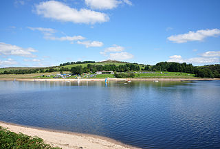
Siblyback Lake is a reservoir on the edge of Bodmin Moor in Cornwall, England, UK.
