
The Hoosier National Forest is a property managed by the United States Forest Service in the hills of southern Indiana. Composed of four separate sections, it has a total area of 202,814 acres. Hoosier National Forest's headquarters are located in Bedford, with a regional office in Tell City. Prominent places within the Forest include the Lick Creek Settlement, Potts Creek Rockshelter Archeological Site, and Jacob Rickenbaugh House.

The American Discovery Trail is a system of recreational trails and roads which collectively form a coast-to-coast hiking and biking trail across the mid-tier of the United States. Horses can also be ridden on most of this trail. It starts on the Delmarva Peninsula on the Atlantic Ocean and ends on the northern California coast on the Pacific Ocean. The trail has northern and southern alternates for part of its distance, passing through Chicago and St. Louis respectively. The total length of the trail including both the north and south routes is 6,800 miles (10,900 km). The northern route covers 4,834 miles (7,780 km) with the southern route covering 5,057 miles (8,138 km). It is the only non-motorized coast-to-coast trail.

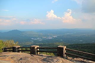
Lookout Mountain is a mountain ridge located at the northwest corner of the U.S. state of Georgia, the northeast corner of Alabama, and along the Tennessee state line in Chattanooga. Lookout Mountain was the scene of the "Last Battle of the Cherokees" during the Nickajack Expedition, which took place in the 18th century, as well as the November 24, 1863, Battle of Lookout Mountain during the American Civil War.
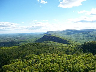
The Shawangunk Ridge, also known as the Shawangunk Mountains or The Gunks, is a ridge of bedrock in Ulster County, Sullivan County and Orange County in the state of New York, extending from the northernmost point of New Jersey to the Catskill Mountains. Shawangunk Ridge is the continuation of the long, easternmost ridge of the Appalachian Mountains; the ridge is known as Kittatinny Mountain in New Jersey, and as Blue Mountain as it continues through Pennsylvania. This ridge constitutes the western border of the Great Appalachian Valley.
Black Rock Mountain State Park is a 1,743-acre (705 ha) Georgia, United States, state park west of Mountain City in Rabun County, in the Blue Ridge Mountains. It is named after its sheer cliffs of dark-colored biotite gneiss. Astride the Eastern Continental Divide at an elevation of 3,640 feet (1,110 m), the park provides many scenic overlooks and 80-mile (130 km) vistas of the southern Appalachian Mountains. On a clear day, four states are visible: Georgia, North Carolina, South Carolina, and Tennessee. In addition to Black Rock Mountain itself, the park includes four other peaks over 3,000 feet (910 m) in elevation, making it the state's highest state park. As of 2019, it was open to visitors year round.

Cloudland Canyon State Park is a 3,485 acres (14.10 km2) Georgia state park located near Trenton and Cooper Heights on the western edge of Lookout Mountain. One of the largest and most scenic parks in Georgia, it contains rugged geology, and offers visitors a range of vistas across the deep gorge cut through the mountain by Sitton Gulch Creek, where the elevation varies from 800 to over 1,800 feet. Views of the canyon can be seen from the picnic area parking lot, in addition to additional views located along the rim trail. At the bottom of the gorge, two waterfalls cascade across layers of sandstone and shale, ending in small pools below.

South Mountain Reservation, covering 2,110 acres (8 km2), is a nature reserve on the Rahway River that is part of the Essex County Park System in northeastern New Jersey, United States. It is located in central Essex County, New Jersey, within portions of Maplewood, Millburn and West Orange, and borders South Orange, between the first and second ridges of the Watchung Mountains.

Little River Canyon National Preserve is a United States National Preserve located on top of Lookout Mountain near Fort Payne, Alabama, and DeSoto State Park. Created by an Act of Congress in 1992, the 15,288-acre (6,187 ha) preserve protects what is sometimes said to be the nation's longest mountaintop river, the Little River. The canyon was historically called "May's Gulf", "gulf" being a common term throughout the Cumberland Plateau for this sort of feature. Prior to being assigned to the National Park Service, the canyon area formed the southmost unit of Alabama's DeSoto State Park.

Curecanti National Recreation Area is a National Park Service unit located on the Gunnison River in western Colorado. Established in 1965, Curecanti is responsible for developing and managing recreational facilities on three reservoirs, Blue Mesa Reservoir, Morrow Point Reservoir and Crystal Reservoir, constructed on the upper Gunnison River in the 1960s by the U.S. Bureau of Reclamation to better utilize the vital waters of the Colorado River and its major tributaries. A popular destination for boating and fishing, Curecanti offers visitors two marinas, traditional and group campgrounds, hiking trails, boat launches, and boat-in campsites. The state's premiere lake trout and Kokanee salmon fisheries, Curecanti is a popular destination for boating and fishing, and is also a popular area for ice-fishing in the winter months.

Ricketts Glen State Park is a Pennsylvania state park on 13,193 acres (5,280 ha) in Columbia, Luzerne, and Sullivan counties in Pennsylvania in the United States. Ricketts Glen is a National Natural Landmark known for its old-growth forest and 24 named waterfalls along Kitchen Creek, which flows down the Allegheny Front escarpment from the Allegheny Plateau to the Ridge-and-Valley Appalachians. The park is near the borough of Benton on Pennsylvania Route 118 and Pennsylvania Route 487, and is in five townships: Sugarloaf in Columbia County, Fairmount and Ross in Luzerne County, and Colley and Davidson in Sullivan County.

Vogel State Park is a 233-acre (0.94 km2) or 94 hectares state park located at the base of Blood Mountain in the Chattahoochee National Forest. It became one of the first two parks in Georgia when it founded a state park system in 1931. Much of the park was constructed by the Civilian Conservation Corps during the 1930s.

Mill Creek Park is a metropolitan park located in Youngstown, Ohio. The Trust for Public Land ranks one part of Mill Creek as the 142nd largest park located within the limits of a US city.

Gulf Hagas is a gorge located in the mountains of northern Maine woods and is often referred to as the Grand Canyon of the East. The West Branch of the Pleasant River cuts through the earth for three miles creating a vertically walled slate gorge with numerous waterfalls. A trail follows the rim of the canyon offering hikers views of the falls and its geology. The gorge is 3 miles (4.8 km) long; the river drops 370 feet (110 m) in this distance boasting 130 feet (40 m) walls. Gulf Hagas is one of 14 National Natural Landmarks in the State of Maine, and is open to the public for a fee during the regular season.

The waterfalls of northern Georgia, U.S., are a prominent feature of the geography of that region, as well as a major focus of tourism and outdoor recreation. Many are located in state parks, national forests, wildlife management areas, and other public lands. Many are accessible—with varying degrees of ease or difficulty—via established hiking trails, and some developed areas include boardwalks, observation platforms, picnic areas, and other amenities. The Cherokee called this region "Land of a Thousand Waterfalls". The third-, fourth-, and fifth-highest waterfalls in the eastern United States are located in northern Georgia.

Cascadia State Park is a state park in the U.S. state of Oregon near Sweet Home along the South Santiam River at Cascadia. The park includes a day use area, campsites, hiking trails and 150 foot Lower Soda Creek Falls.

The Walls of Jericho is a 750-acre (300 ha) natural area that is within the 8,943-acre (3,619 ha) Bear Hollow Mountain Wildlife Management Area (WMA) in Tennessee, which is contiguous to the Skyline WMA in Alabama. It was designated in 2016 and is owned by State of Tennessee. Both of the public lands on the Tennessee and Alabama side total 21,453 acres (8,682 ha). The initiative to acquire this land was a lengthy project completed by The Nature Conservancy in Tennessee and Alabama. The natural area is approximately twelve miles south of Winchester in southern Franklin County.
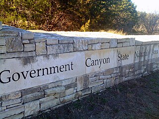
First opened to the public in October, 2005, Government Canyon State Natural Area (GCSNA) preserves 12,244 acres of rugged hills and canyons typical of the Texas Hill Country. It is designated a Natural Area, rather than a State Park, and therefore the primary focus is maintenance and protection of the property's natural state. Accordingly, access and recreational activities may be restricted if the Texas Parks & Wildlife Department (TPWD) deems such action necessary to protect the environment.
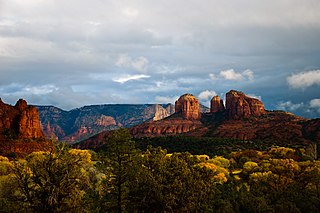
Red Rock State Park is a state park of Arizona, USA, featuring a red sandstone canyon outside the city of Sedona. The main mission of this day-use park is the preservation of the riparian habitat along Oak Creek. Red Rock State Park serves as an environmental education facility for the public and for school or private groups, and provides limited passive recreational opportunities.

The Fiery Gizzard Trail runs from Tracy City, Tennessee to Foster Falls in Marion County, Tennessee. It is renowned for its beauty and diversity, cited by Backpacker magazine as one of the top 25 hiking trails in the United States. The 12.5-mile (20.1 km) trail offers scenic views, waterfalls, rock formations, and hemlock trees over 200 years old.

Cuba Lake is a 454-acre (1.84 km2) reservoir in Allegany and Cattaraugus counties, New York.

