Lullingstone Country Park

Last updated

Lullingstone Country Park
Bridleway junction in Lullingstone Country Park - geograph.org.uk - 1349910.jpg
Lullingstone Country Park
Coordinates 51°11′31″N0°14′51″E / 51.1919°N 0.2475°E / 51.1919; 0.2475 Coordinates: 51°11′31″N0°14′51″E / 51.1919°N 0.2475°E / 51.1919; 0.2475
Area186 hectares (460 acres)
Created1960's (1960's)
Operated by Kent County Council,
Open7 days a week, dawn until dusk
Website Lullingstone Country Park
Lullingstone Park
Site of Special Scientific Interest
Location Kent
Grid reference TQ 513 640 [1]
InterestBiological
Area66.4 hectares (164 acres) [1]
Notification 1989 [1]
Location map Magic Map

Lullingstone Country Park is near Eynsford, in Kent, England. A former deer park of a large estate, it was later sold to become an open-space and woodland park. The park and Lullingstone Castle are a Scheduled Monument, [2] and an area of 66.4-hectare (164-acre) is a biological Site of Special Scientific Interest Kent. [1] [3]

Contents

History

This 460-acre country park is between Eynsford and Shoreham; it was formerly a medieval deer park, and part of the estate and Manor of Lullingstone, which was mentioned in the Domesday Survey. In 1934, much of the park was sold to Kemp Town Brewery, Brighton who later sold it to Kent County Council in 1938.

In 1944, during the 2nd World War, a decoy airfield was sited in the park, and Lullingstone Castle was used by the army. [4] The Lullingstone estate was also hit by various German bombs; most craters have been covered up. One crater is now hidden by trees. [5]

In the mid-1960s, Kent County Council leased the park to Dartford Rural District Council, who created an 18-hole golf course in the park. Later in the 20th century, a 9-hole course was also added. This still occupies the western and central section of the park. [6] The park is currently leased by Sevenoaks District Council, but the park is maintained by Kent County Council. Lullingstone Castle and its grounds remain in private ownership under the Hart-Dykes. [4]

In 1964, Summerhouse Knoll (a grass hill) within the park was dug up by Crayford Archaeological Research Group who found 1st-century pottery. [7] [8]

Some of the pollards in the wood are over 400 years old, and it is important for invertebrates, lichens, breeding birds and fungi. Over 340 beetle species have been recorded, including two which are nationally rare. [9]

Geography

Lullingstone Country Park Information Board Information board about Lullingstone Country Park - geograph.org.uk - 1355344.jpg
Lullingstone Country Park Information Board

The park is well renowned for its collection of ancient trees within the park. These include 300 veteran oaks, beeches, hornbeams, ash (Fraxinus), and sweet chestnut trees. These include specimens estimated to be around 500 years old. [10] As well as the woodlands, the park has large meadow land areas, with plentiful species of plants within, including orchids and other native wildflowers and butterflies. [11]

The River Darent flows through the eastern valley section of the park, alongside the Darent Valley Path (long-distance path). Sections of the river are widened to create lakes and ponds. These also attract wildlife including, kingfishers, herons, grass snakes, dragonflies and damselflies. [11]

Several marked trails exist within the park. The White Woodland Walk is a 2-mile heading through Beechen Wood and past the Orchid Bank. The Black Lullingstone Loop is a 4-mile perimeter walk, via Beechen Wood (a Site of Special Scientific Interest [12] ), passing Lullingstone Roman Villa, Lullingstone Castle. It passes many of the ancient trees in the park. The Red Discovery Trail is a 1.5-mile child-friendly activity trail. The Blue Horse Trail is 4 miles. Other footpaths including public footpaths also exist within the park.

The country park held a Kent Big Weekend Event during March 2011 in the grounds of the Country Park. [13]

The park also is accredited with a Green Flag Award by Natural England. [14]

See also

Lullingstone Castle Lullingstone.manor.JPG
Lullingstone Castle

Nearby, is the 15th-century Lullingstone Castle and Tom Hart Dyke's World of Garden Plants. [15] Also, within 1 mile of the country park is another less visited Park and woodland of Preston Hill Country Park.

How to get there

From Eynsford, follow the A225 towards Otford. The park is on the right, after the entrance to Lullingstone Castle. Another entrance is via footpaths through Beechens Wood from Redmans Lane (bordering the park on the south).

Related Research Articles

<span class="mw-page-title-main">Eynsford</span> Human settlement in England

Eynsford is a village and civil parish in the Sevenoaks District of Kent, England. It is located 3.3 miles (5 km) south east of Swanley, 7 miles (11 km) south of Dartford.

<span class="mw-page-title-main">Lullingstone</span> Human settlement in England

Lullingstone is a village in the county of Kent, England. It is best known for its castle, Roman villa and its public golf course.

<span class="mw-page-title-main">Eynsford railway station</span> Railway station in Kent, England

Eynsford railway station serves Eynsford in Kent, England. It is 20 miles 32 chains (32.8 km) down the line from London Victoria and is situated between Swanley and Shoreham. Train services are provided by Thameslink.

<span class="mw-page-title-main">Lullingstone Castle</span>

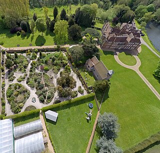
Lullingstone Castle is a historic manor house, set in an estate in the village of Lullingstone and the civil parish of Eynsford in the English county of Kent. It has been inhabited by members of the Hart Dyke family for twenty generations including current owner Tom Hart Dyke.

The following is a list of recreational walks in Kent, England.

<span class="mw-page-title-main">Burham Down</span>

Burham Down is a 110-hectare (270-acre) nature reserve between Maidstone and Chatham in Kent. It is managed by the Kent Wildlife Trust. It is part of the Wouldham to Detling Escarpment Site of Special Scientific Interest and Nature Conservation Review site, Grade I, the Kent Downs Area of Outstanding Natural Beauty, and the North Downs Woodlands Special Area of Conservation.

<span class="mw-page-title-main">Wye and Crundale Downs</span>

Wye and Crundale Downs is a 358.3-hectare (885-acre) biological and geological Site of Special Scientific Interest in a number of separate areas east of Ashford in Kent. It is a Special Area of Conservation and a Nature Conservation Review site, Grade I. and it is part of Kent Downs Area of Outstanding Natural Beauty. Some areas are part of a National Nature Reserve, and another area is listed on the Geological Conservation Review.

<span class="mw-page-title-main">Sheet Hedges Wood</span>

Sheet Hedges Wood is in the parish of Newtown Linford, and lies some 1-mile (1.6 km) north of Groby, in Leicestershire, UK. The site is made up of two areas of woodland and a meadow field, all with public access, extending 29 acres (120,000 m2). The woodland block is adjacent to the road includes a car park and access trails.

<span class="mw-page-title-main">Darent Valley Path</span>

The waymarked path Darent Valley Path is 19 miles (31 km) long, following the River Darent from the banks of the River Thames at Dartford through the Kent Downs Area of Outstanding Natural Beauty to the Greensand Hills above Sevenoaks. It runs through the villages of Shoreham and Otford.

<span class="mw-page-title-main">Shorne Wood Country Park</span>

Shorne Wood Country Park is located between Strood and Gravesend, in the English county of Kent. It was once part of a large estate, later passed to the county council to be used as a country park.

<span class="mw-page-title-main">Stubbs Wood Country Park</span>

Stubbs Wood Country Park is in Sevenoaks, in Kent, England. It is located on the Greensand Ridge, close to Ide Hill village. The site is owned and managed by Sundridge with Ide Hill Parish Council.

<span class="mw-page-title-main">Preston Hill Country Park</span>

Preston Hill Country Park is in Eynsford, in Kent, England. It is a woodland and former military firing range.

Darenth Country Park is in Darenth near Dartford, in Kent, England. On the site of a former demolished hospital site Darenth Park Hospital, also the site of a scheduled ancient monument and the site of ancient Saxon burials. Due to this protection it was turned into a millennium open-space park.

<span class="mw-page-title-main">Crickley Hill and Barrow Wake</span>

Crickley Hill and Barrow Wake is a 56.8-hectare (140-acre) biological and geological Site of Special Scientific Interest in Gloucestershire, notified in 1974.

<span class="mw-page-title-main">Hay-a-Park Gravel Pit</span> Site of Special Scientific Interest in North Yorkshire, England

Hay-a-Park Gravel Pit is a Site of Special Scientific Interest, or SSSI, adjacent to the east side of the town of Knaresborough, North Yorkshire, England. Having been a disused and flooded quarry since the 1970s, it now consists of the large Hay-a-Park Lake and three smaller ponds, besides associated reedbeds, scrub, woodland and grassland. It was designated as a SSSI in 1995 because it supports a number of wintering birds, including a large flock of goosander. This site is "one of the most northerly inland breeding populations of reed warbler in Britain." Hay-a-Park was once part of a royal park, an early landowner being Edward II.

<span class="mw-page-title-main">Cow Myers (wetland)</span> Site of Special Scientific Interest in North Yorkshire, England

Cow Myers is a Site of Special Scientific Interest (SSSI) located in the Nidderdale Area of Outstanding Natural Beauty (AONB), near Ripon, North Yorkshire, England. The site was designated in 1984 for its fen and alder carr habitat, which supports a diversity of wetland plant life. Of particular interest are the bird's eye primrose which is scarce in Yorkshire, and early marsh orchid. There is no public access to this site, no vehicular access, and no public facilities.

<span class="mw-page-title-main">Bishop Monkton Ings</span> Site of Special Scientific Interest in North Yorkshire, England

Bishop Monkton Ings is a Site of Special Scientific Interest, or SSSI, situated east of Bishop Monkton village in North Yorkshire, England. It consists mostly of marshy, calcareous grassland, with some broadleaved woodland, and some fen alongside the two watercourses which run through the site. This varied wetland forms a habitat for a variety of plants, including the semi-parasitic marsh lousewort (Pedicularis palustris).

<span class="mw-page-title-main">Mar Field Fen</span> Site of Special Scientific Interest in North Yorkshire, England

Mar Field Fen is a Site of Special Scientific Interest, or SSSI, north of Masham, North Yorkshire, England, in a rural area known as Marfield. It is situated on land containing woodland carr, fen, spring-fed marshy grassland and drier calcareous grassland, between the River Ure to the east and Marfield Wetland nature reserve to the west. As "one of the best examples of fen habitat in the Vale of York," it is a protected habitat for a variety of plants, including the common butterwort, a carnivorous plant. There is no public access to this site.

<span class="mw-page-title-main">Hack Fall Wood</span> Site of Special Scientific Interest in North Yorkshire, England

Hack Fall Wood, otherwise known as Hackfall, is a Site of Special Scientific Interest, or SSSI, of 44.8687 hectares, lying north-east of the village of Grewelthorpe, North Yorkshire, England. During the 18th century it was landscaped in the picturesque style by landowner William Aislabie, who created views by engineering streams and pools, planting trees and building follies. Turner and Gilpin painted it, and pictures of it featured on Catherine the Great's 1773 Wedgwood dinner service. Some 19th century writers called it "one of the most beautiful woods in the country."

<span class="mw-page-title-main">Ripon Parks</span> Site of Special Scientific Interest in North Yorkshire, England

Ripon Parks is a Site of Special Scientific Interest, or SSSI, situated north of Ripon, to the west of the River Ure and to the east of the village of North Stainley, in North Yorkshire, England. It was once part of the land held since the Middle Ages as a deer park by the archbishops of York and the canons of Ripon. The site was designated as an SSSI in 1983, because its varied habitats are valued for their breeding birds, amphibians and varied flora. The woods here are "of note" for the parasitic flowers of common toothwort and yellow star-of-Bethlehem. A small part of the site is accessible via public footpaths; there are no public facilities or dedicated car parks. The site incorporates the High Batts Nature Reserve, which is privately run for training, recording and educational purposes, and accessible to members only, except for its annual open day. Ripon Parks is now owned by the Ministry of Defence, and parts of the site are used as military training areas.

References

  1. 1 2 3 4 "Designated Sites View: Lullingstone Park". Sites of Special Scientific Interest. Natural England. Retrieved 15 February 2018.
  2. "Lullingstone Castle". Historic England. Retrieved 15 February 2018.
  3. "Map of Lullingstone Park". Sites of Special Scientific Interest. Natural England. Retrieved 15 February 2018.
  4. 1 2 "Parks and Gardens UK". Archived from the original on 17 June 2012. Retrieved 22 June 2011.
  5. "Lullingstone during World War II". Archived from the original on 19 July 2011. Retrieved 22 June 2011.
  6. "Sencio Community Leisure". Lullingstonegolfcourse.co.uk. Retrieved 24 October 2018.
  7. "Article from the Kent Archaeological Review, Autumn 1965 (Issue #1) -- Summer House Knoll, Lullingstone Park." Cka.moon-demon.co.uk. Retrieved 24 October 2018.
  8. "Article from the Kent Archaeological Review, Summer 1967 (Issue #8) -- Further Excavations at Lullingstone." Cka.moon-demon.co.uk. Retrieved 24 October 2018.
  9. "Lullingstone Park citation" (PDF). Sites of Special Scientific Interest. Natural England. Retrieved 15 February 2018.
  10. "Ancient trees to be preserved at Lullingstone Country Park". Sevenoaksforum.com. Retrieved 24 October 2018.
  11. 1 2 "Lullingstone". Rspbgravesend.org.uk. Retrieved 24 October 2018.
  12. "SSSI name: Lullingstone Park". Sssi.naturalengland.org.uk. 1981. Retrieved 12 November 2013.
  13. "Manor Park Country Park - My Kent Big Weekend 2011". bigweekend.mykent.co.uk. Archived from the original on 24 January 2011. Retrieved 15 January 2022.
  14. "Country Parks in the South East". Naturalengland.org.uk. Natural England. 2013. Retrieved 2 December 2013.
  15. "Lullingstone Castle: Nobody's vault but mine - Telegraph". Archived from the original on 30 December 2013. Retrieved 2 April 2018.