
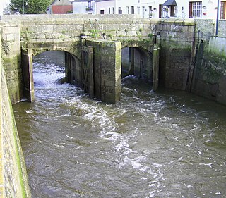
The Orne is a river in Normandy, within northwestern France. It is 170 km (110 mi) long. It discharges into the English Channel at the port of Ouistreham. Its source is in Aunou-sur-Orne, east of Sées. Its main tributaries are the Odon and the Rouvre.

The Rance is a river of northwestern France. It is 103.6 km (64.4 mi) long. It flows into the English Channel between Dinard and Saint-Malo.
Streamflow, or channel runoff, is the flow of water in streams, rivers, and other channels, and is a major element of the water cycle. It is one component of the runoff of water from the land to waterbodies, the other component being surface runoff. Water flowing in channels comes from surface runoff from adjacent hillslopes, from groundwater flow out of the ground, and from water discharged from pipes. The discharge of water flowing in a channel is measured using stream gauges or can be estimated by the Manning equation. The record of flow over time is called a hydrograph. Flooding occurs when the volume of water exceeds the capacity of the channel.

The Couesnon is a river running from the département of Mayenne in north-western France, forming an estuary at Mont Saint-Michel. It is 97.8 km (60.8 mi) long, and its drainage basin is 1,124 km2 (434 sq mi). Its final stretch forms the border between the historical duchies of Normandy and Brittany. Its historically irregular course, alternating between two beds on the north and south of the Mont Saint-Michel but eventually definitely settling to the south bed, inspired the saying "The Couesnon in its madness placed the Mont in Normandy", as the Mont is just to the Norman side of the river's current mouth. However, the administrative boundary separating the two regions does not depend on the course of the river, and is about six kilometers west of the Mont.

Sonoma Creek is a 33.4-mile-long (53.8 km) stream in northern California. It is one of two principal drainages of southern Sonoma County, California, with headwaters rising in the rugged hills of Sugarloaf Ridge State Park and discharging to San Pablo Bay, the northern arm of San Francisco Bay. The watershed drained by Sonoma Creek is roughly equivalent to the wine region of Sonoma Valley, an area of about 170 square miles (440 km2). The State of California has designated the Sonoma Creek watershed as a “Critical Coastal Water Resource”. To the east of this generally rectangular watershed is the Napa River watershed, and to the west are the Petaluma River and Tolay Creek watersheds.

The River Bourne is a small river in Dorset, England. It flows into the English Channel at Bournemouth, taking its name simply from Middle English bourn or burn, a small stream, and giving it to the town at its mouth.

Branciforte Creek is a 5.8-mile (9.3 km) long watercourse in Santa Cruz County, California, United States. Branciforte Creek rises on the western slopes of the Santa Cruz Mountains and discharges to the San Lorenzo River, which in turn empties into the Pacific Ocean. Within the State of California Branciforte Creek is classified within the Central Coast Basin. As of the year 2002, the State of California has designated Branciforte Creek as impaired with respect to turbidity and pathogens. The Branciforte watershed consists of 6,231 acres (25.22 km2), approximately 70 percent of which is covered with mixed evergreen forest, conifer forest and other undisturbed habitats.
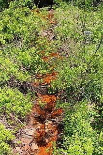
The Burn of Pheppie is an easterly flowing coastal stream in Aberdeenshire, Scotland that discharges to the North Sea immediately north of the village of Muchalls. Draining chiefly agricultural lands, this stream has a notable lack of turbidity and a pH level of approximately 8.02. Armouring of the stream bottom consists of pebbles, many of which are quartzite in composition, leading to a golden-green effect in some locations. Other nearby watercourses discharging to the North Sea include Burn of Elsick to the north and Burn of Muchalls to the south.

The Cowie Water is a river of Scotland.

The Lunan Water is an easterly flowing river in Angus, Scotland, that discharges to the North Sea 11 kilometres (6.8 mi) north of the town of Arbroath. Draining chiefly agricultural lands, this stream has a moderate level of turbidity and a pH level of approximately 8.7. Other nearby watercourses discharging to the North Sea include River North Esk and River South Esk, both to the north. At its mouth the Lunan Water meets the North Sea at the hamlet of Lunan, upon Lunan Bay. The beach at Lunan Bay was voted the "best beach in Scotland" in a survey conducted in the year 2000. The 15th-century ruins of Red Castle are located at the river mouth, close to Lunan.
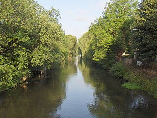
The Aure is a river in northwestern France, in the department of Calvados. It is 82.1 km (51.0 mi) long. Its source is in Caumont-l'Éventé, and it flows into the river Vire in Isigny-sur-Mer. The largest town on the Aure is Bayeux.
Sugar Run Creek is a tributary of the Susquehanna River in Bradford County, Pennsylvania, in the United States. It is approximately 7.9 miles (12.7 km) and flows through North Branch Township, Windham Township, and Wilmot Township.
The Nonette is a tributary to the river Oise in northern France. It is 40.4 km (25.1 mi) long. Its source is in Nanteuil-le-Haudouin, from which it flows west through Senlis and Chantilly, and joins the Oise near Saint-Leu-d'Esserent.

A stream is a continuous body of surface water flowing within the bed and banks of a channel. Depending on its location or certain characteristics, a stream may be referred to by a variety of local or regional names. Long large streams are usually called rivers, while smaller, less voluminous and more intermittent streams are known as streamlets, brooks or creeks, etc.
Little Wapwallopen Creek is a tributary of the Susquehanna River in Luzerne County, Pennsylvania, in the United States. It is approximately 17 miles (27 km) long and flows through Rice Township, Dorrance Township, Conyngham Township, and Hollenback Township. The watershed of the creek has an area of 39.5 square miles (102 km2). The creek is designated as a Coldwater Fishery and a Migratory Fishery and is not considered to be impaired. It has two named tributaries: Pond Creek and Nuangola Outlet. Wild trout naturally reproduce in the creek.
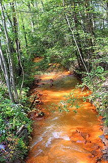
Nanticoke Creek is a tributary of the Susquehanna River in Luzerne County, Pennsylvania, in the United States. It is approximately 4.4 miles (7.1 km) long and flows through Hanover Township and Nanticoke. The watershed of the creek has an area of 7.57 square miles (19.6 km2). The creek has one named tributary, which is known as Espy Run. Nanticoke Creek impaired by pH and metals due to abandoned mine drainage. Abandoned mine drainage discharges in the creek's watershed include the Truesdale Mine Discharge and the Askam Borehole. The creek is located in the Northern Middle Anthracite Field and is in the Anthracite Valley Section of the ridge and valley physiographic province. The main rock formations in the watershed include the Mauch Chunk Formation, the Pottsville Group, and the Llewellyn Formation. The surficial geology consists of coal dumps, surface mining land, alluvium, Wisconsinan Outwash, Wisconsinan Till, urban land, and bedrock.

Spring Brook is a tributary of the Lackawanna River in Lackawanna County and Luzerne County, in Pennsylvania, in the United States. It is approximately 17 miles (27 km) long and flows through Covington Township, Spring Brook Township, and Moosic in Lackawanna County and Pittston Township in Luzerne County. The watershed of the stream has an area of 57.2 square miles (148 km2). It is designated as a High-Quality Coldwater Fishery and a Migratory Fishery above Interstate 476 and as a Coldwater Fishery and a Migratory Fishery below it. A section is also designated as Class A Wild Trout Waters. The stream's tributaries include Panther Creek, Plank Bridge Creek, Rattlesnake Creek, Green Run, Monument Creek, and Covey Swamp Creek. It has a relatively high level of water quality and is very slightly acidic, with a pH of 6.4 to 6.9.
Quaker Run is a tributary of Shamokin Creek in Northumberland County, Pennsylvania, in the United States. It is approximately 3.7 miles (6.0 km) long and flows through Kulpmont, Mount Carmel Township, and Coal Township. The watershed of the stream has an area of 3.62 square miles (9.4 km2). The stream has one unnamed tributary. Quaker Run is designated as an impaired waterbody due to metals from abandoned mine drainage. Raw sewage and stormwater have also been discharged into it at times.
Locust Creek is a tributary of Shamokin Creek in Northumberland County, Pennsylvania, in the United States. It is approximately 4.0 miles (6.4 km) long and flows through East Cameron Township and Mount Carmel Township. The watershed of the creek has an area of 5.75 square miles (14.9 km2). The stream is designated as impaired due to metals from abandoned mine drainage. It also experiences a low pH. The creek flows through a water gap in Locust Mountain. Prominent land uses in its watershed include refuse areas and forested land. The creek's watershed is designated as a Coldwater Fishery and a Migratory Fishery.
