
Exmoor is loosely defined as an area of hilly open moorland in west Somerset and north Devon in South West England. It is named after the River Exe, the source of which is situated in the centre of the area, two miles north-west of Simonsbath. Exmoor is more precisely defined as the area of the former ancient royal hunting forest, also called Exmoor, which was officially surveyed 1815–1818 as 18,810 acres (7,610 ha) in extent. The moor has given its name to a National Park, which includes the Brendon Hills, the East Lyn Valley, the Vale of Porlock and 55 km (34 mi) of the Bristol Channel coast. The total area of the Exmoor National Park is 692.8 km2 (267.5 sq mi), of which 71% is in Somerset and 29% in Devon.

North Devon is a local government district in Devon, England. Its council is based just outside Barnstaple, the district's largest town. The district also includes the towns of Ilfracombe, Lynton and Lynmouth and South Molton along with numerous villages, seaside resorts and surrounding rural areas.

Lynmouth is a village in Devon, England, on the northern edge of Exmoor. The village straddles the confluence of the West Lyn and East Lyn rivers, in a gorge 700 feet (210 m) directly below the neighbouring town of Lynton, which was the only place to expand to once Lynmouth became as built-up as possible. The villages are connected by the Lynton and Lynmouth Cliff Railway, which works two cable-connected cars by gravity, using water tanks.
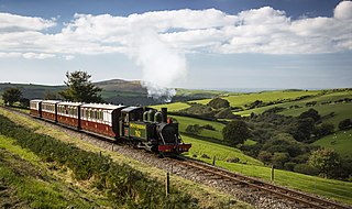
The Lynton and Barnstaple Railway (L&B) was a single track, 1 ft 11+1⁄2 in narrow gauge railway. It opened in May 1898 and ran for slightly more than 19 miles (31 km) through the area bordering Exmoor in North Devon, England. Although it opened after the Light Railways Act 1896 came into force, it was authorised and constructed before that act. It was authorised under its own Act of Parliament and built to higher standards than similar railways of the time. It was notable as the only narrow gauge railway in Britain that was required to use main-line standard signalling. For a short period, it earned a modest return for shareholders, but for most of its existence it made a loss. In 1923, the L&B was taken over by the Southern Railway, and eventually closed in September 1935.

Blackmoor railway station, situated near to Blackmoor Gate at the western boundary of Exmoor National Park, England, was a station on the Lynton and Barnstaple Railway, a narrow gauge line that ran through Exmoor from Barnstaple to Lynton and Lynmouth in North Devon.

Bratton Fleming railway station is a former station on the Lynton and Barnstaple Railway in England, a narrow gauge line that ran through Exmoor from Barnstaple to Lynton and Lynmouth in North Devon. The station served the village of Bratton Fleming. It opened with the line on 11 May 1898, and closed with it after service on 29 September 1935. From 1923 until closure, the line was operated by the Southern Railway.
Caffyns Halt was a halt on the Lynton and Barnstaple Railway, a narrow gauge line that ran through Exmoor, England, from Barnstaple to Lynton and Lynmouth in North Devon. The station primarily served Caffyns Golf Links, as well as the rural area near the hamlet of Dean. It opened in 1907, and closed on 29 September 1935. From 1923 until closure the line was operated by the Southern Railway.

Chelfham railway station was a station on the Lynton and Barnstaple Railway, a narrow gauge line that ran through Exmoor from Barnstaple to Lynton and Lynmouth in North Devon, England. The station stood at the head of the spectacular Chelfham Viaduct, and served the village of Chelfham below.
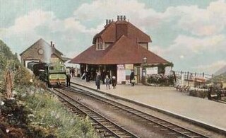
Lynton and Lynmouth railway station was the terminus of the Lynton and Barnstaple Railway, a narrow gauge line that ran through Exmoor from Barnstaple to Lynton and Lynmouth in North Devon, England. The station served the twin towns of Lynton and Lynmouth.
Parracombe railway station was a halt on the Lynton & Barnstaple Railway, a narrow gauge line that ran through Exmoor from Barnstaple to Lynton and Lynmouth in North Devon, England. The Halt which served the village of Parracombe comprised a simple wooden shelter and was not opened until 1 May 1899 — almost a year after the line was opened on 16 May 1898 — and closed along with the rest of the railway on 29 September 1935. It is planned this station will be reopened next by the Lynton & Barnstaple Trust. It will replace the station at Killington Lane a bit further to the north that was opened in 2006.

The Lynton and Lynmouth Cliff Railway is a water-powered funicular joining the twin towns of Lynton and Lynmouth on the rugged coast of North Devon in southwest England.

The River Heddon is a river in Devon, in the south of England. Running along the western edges of Exmoor, the river reaches the North Devon coast at Heddon's Mouth. The nearest road access to the beach is at Hunter's Inn, approximately 1.6-kilometre (1 mi) south of sea-fall. The named river flows for 8.8 kilometres (5.5 mi) and drains an area of 17.07 square kilometres (6.59 sq mi).

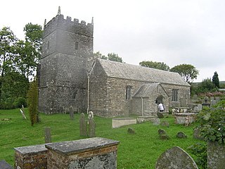
Brendon is a village and former civil parish, now in the parish of Brendon and Countisbury, in the North Devon district, in the county of Devon, England. It is close to the border with Somerset within the Exmoor National Park, the village is 1.5 miles (2.4 km) southeast of Lynton and 15 miles (24 km) west of Minehead in the East Lyn Valley. It is located just off the A39 and is on two long distance footpaths, the Coleridge Way and the Samaritans Way South West. The Church of St Brendon is 2 mi (3 km) from the village and was built in 1738, possibly with building material brought from another site. In 2001 the parish had a population of 159.

The West Lyn is a river in England which rises high in Exmoor, Somerset, and joins the East Lyn at Lynmouth in Devon.

Roborough Castle is an Iron Age enclosure or hill fort situated close to Lynton in Devon, England. The fort is situated on the North East edge of a Hillside forming a promontory above a tributary to the East Lyn River known as Hoaroak Water at approx 320 Metres above Sea Level.

The Valley of Rocks, sometimes called Valley of the Rocks, is a dry valley that runs parallel to the coast in north Devon, England, about 1 kilometre (0.6 mi) to the west of the village of Lynton. It is a popular tourist destination, noted for its herd of feral goats, and for its landscape and geology.
Parracombe is a rural settlement 4 miles (6 km) south-west of Lynton, in Devon, England. It is situated in the Heddon Valley, on Exmoor. The population at the 2011 census was 293.
Lynmouth Bay railway station is a station in Lynmouth, Devon, England, served by the Lynton and Lynmouth Cliff Railway, a water-powered funicular railway. The station has two platforms, a ticket booth, not an office, a bench and plenty of room. It opened in 1890.

Lynton and Lynmouth is a civil parish in the North Devon district of Devon, England. The parish is named after its two main settlements of Lynton, which stands on a plateau above the Glen Lyn Gorge, and Lynmouth which lies at the foot of the gorge where the West Lyn River and East Lyn River converge and then meet the sea. The two are connected by the Lynton and Lynmouth Cliff Railway, a water-powered funicular railway.

Martinhoe is a small settlement and civil parish in North Devon district of Devon, England. Martinhoe is within the Exmoor National Park, the smallest National Park in England. In the 2011 census Martinhoe Parish was recorded as having a population of 159. Martinhoe is in the Combe Martin ward, for elections to the district council. Martinhoe's local government takes the form of a parish meeting and as such has no parish council nor elected parish councillors.

