
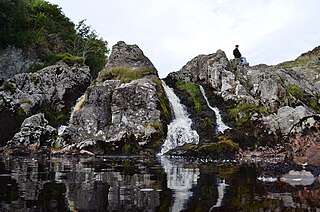
Lynn Spout is a waterfall on the Caaf Water near Dalry in Ayrshire in Scotland. [1]
Lynn Spout is a waterfall on the Caaf Water near Dalry in Ayrshire in Scotland. [1]

The Rotten Calder is a river to the east of East Kilbride, South Lanarkshire, Scotland and along with the Rotten Burn it forms the southern and western boundaries of Blantyre.
Gleniffer Braes is a short range of hills and park area to the south of Paisley, Scotland which form the boundary of Renfrewshire and North Ayrshire.

The River Garnock, the smallest of Ayrshire's six principal rivers, has its source on the southerly side of the Hill of Stake in the heart of the Clyde Muirshiel Regional Park. About a mile and a half south of this starting point the untested stream tumbles over the Spout of Garnock, the highest waterfall in Ayrshire, once thought to be the river's origin. The river then continues, for a total length of 20 miles (32 km) or so, through the towns of Kilbirnie, Glengarnock, Dalry and Kilwinning to its confluence with the River Irvine at Irvine Harbour.
Netalzul Meadows Provincial Park is a provincial park in British Columbia, Canada. It is located in the Harold-Price watershed, about 50 km north of Smithers. The park consists of an unusual wet meadow complex, as well as a spectacular waterfall and rare plant species.

Tamasopo is a municipality and town in the Mexican state of San Luis Potosí. The town is located at 21°55′21″N99°23′33″W. The municipality had an area of 1,329 square kilometres (513 sq mi) and a population of 28,848 in 2010, including the population of the town of Tamasopo with 4,326 people.

White Coomb is a hill in the Moffat Hills range, part of the Southern Uplands of Scotland. Its broad summit is the highest point in the range and the registration county of Dumfriesshire, as well as being the fourth highest point in southern Scotland, however, despite this, it is largely concealed by other hills on all sides except its east and south east, making this the only direction from which its full scale can be seen.

Closeburn is a village and civil parish in Dumfries and Galloway, Scotland. The village is on the A76 road 2+1⁄2 miles (4 km) south of Thornhill. In the 2001 census, Closeburn had a population of 1,119. Closeburn is recorded as Killosbern in 1185. The first element of the name is Gaelic cill 'cell or church'. The second element is a saint's name, but none has definitely been identified.

Talla Water is a river in the Scottish Borders area of Scotland, near Tweedsmuir. It feeds the Talla Reservoir, and is a tributary of the River Tweed. Above the reservoir are a series of waterfalls known as the Talla Linns.

Drunmore Linn is a waterfall of Scotland, near Straiton, South Ayrshire.

Eas a' Chrannaig also known as the Glenashdale Falls is a waterfall on the island of Arran, Scotland. There are a series of falls on the Glenashdale Burn, which flows from moorland near the summit of Tighvein eastwards towards Whiting Bay, from which there is a tourist trail leading some 4 kilometres (2.5 mi) up Glenashdale.

Waukers Linn is a waterfall on Polharrow Burn in Dumfries and Galloway, Scotland.

Tairlaw Linn is a waterfall of Scotland, near Straiton, South Ayrshire.
Hespies Linn is a waterfall of Scotland.
Loups of Dalnigap is a waterfall of Scotland. It sits below Dalnigap House, in the South of the Lagafater Estate.

Garpel Linn is a waterfall of Scotland.
Eas Mor (lower) is a waterfall on the Abhainn Ghil on the island of Islay, in Scotland. It lies on the west coast of The Oa peninsula north of Lower Killeyan.
Eas Mor is a waterfall is a waterfall on the Abhainn Ghil on the island of Islay in Scotland. It lies on The Oa peninsula south of Giol and west of Lenavore.
Fairy Loup is a waterfall located on Byre Burn, a tributary of River Esk, in Dumfries and Galloway, Scotland.

Falls of Barvick is a waterfall in Scotland. It is 492 feet (150 m) at its highest point and has an average width of 20 feet (6.1 m). It is a cascades type waterfall.
Falls of Glas Allt is a 50-metre (160 ft) waterfall near the head of Loch Muick, Aberdeenshire, Scotland. Queen Victoria liked to take walks here beside the stream flowing from Lochnagar down to Loch Muick. After the death of Prince Albert she had a cottage, Glas-allt-Shiel, rebuilt for her on the delta where the stream flows into the loch.
Coordinates: 55°41′55″N4°44′01″W / 55.69857°N 4.73366°W
| | This Scottish location article is a stub. You can help Wikipedia by expanding it. |