
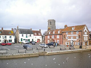
Corfe Castle is a village and civil parish in the English county of Dorset. It is the site of a ruined castle of the same name. The village and castle stand over a gap in the Purbeck Hills on the route between Wareham and Swanage. The village lies in the gap below the castle and is around four miles (6.4 km) south-east of Wareham, and four miles (6.4 km) north-northwest of Swanage. Both the main A351 road from Lytchett Minster to Swanage and the Swanage Railway thread their way through the gap and the village.

Poole is a coastal town and seaport on the south coast of England in the Bournemouth, Christchurch and Poole unitary authority area in Dorset, England. The town is 21 miles (34 km) east of Dorchester and adjoins Bournemouth to the east. Since 1 April 2019, the local authority is Bournemouth, Christchurch and Poole Council. The town had an estimated population of 151,500 making it the second-largest town in the ceremonial county of Dorset. Together with Bournemouth and Christchurch, the conurbation has a total population of nearly 400,000.

Lytchett Minster is a village in Dorset, England. It lies around 4 miles (6.4 km) north-west of Poole town centre. The village forms part of the civil parish of Lytchett Minster and Upton, Upton now being a suburb of Poole.
Wareham is a historic market town and, under the name Wareham Town, a civil parish, in the English county of Dorset. The town is situated on the River Frome eight miles (13 km) southwest of Poole.

Purbeck was a local government district in Dorset, England. The district was named after the Isle of Purbeck, a peninsula that forms a large proportion of the district's area. However, it extended significantly further north and west than the traditional boundary of the Isle of Purbeck which is the River Frome. The district council was based in the town of Wareham, which is itself north of the Frome.

Lytchett Matravers is a large village and civil parish in Dorset, England. The 2011 census recorded the parish as having 1,439 households and a population of 3,424.

Upton is a town in south-east Dorset, England. Upton is to the east of Holton Heath and Upton Heath, and to the north of the Poole suburb of Hamworthy. It is the second largest town in the Purbeck Hills.
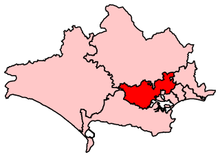
Mid Dorset and North Poole is a constituency represented in the House of Commons of the UK Parliament since 2015 by Michael Tomlinson, a Conservative.
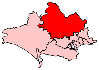
North Dorset is a constituency represented in the House of Commons of the UK Parliament since 2015 by Simon Hoare, a Conservative.

Hamworthy is a village, parish, peninsula and suburb of Poole in Dorset, England. It is sited on a peninsula of approximately 3 square kilometres (1.2 sq mi) that is bordered by the town of Upton to the north, Poole Harbour to the south, Lytchett Bay to the west and Holes Bay to the east. Poole Bridge, the southern terminus of the A350 road, connects the suburb with the town centre. Hamworthy is the location of the Port of Poole ferry passenger terminal and cargo handling operations.
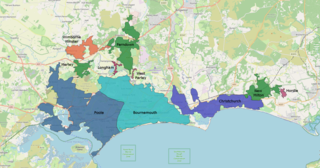
The South East Dorset conurbation is a multi-centred conurbation on the south coast of Dorset in England.
Lytchett Minster School is a comprehensive school, with about 1,400 students aged 11 to 18, and 100 teachers, in Lytchett Minster, just outside Upton, 4 miles (6 km) from Poole, Dorset, England.

Wareham St Martin is a civil parish in the English county of Dorset. The parish spreads across a large, and mostly rural area to the north of the town of Wareham including much of Wareham Forest. However the town of Wareham lies within its own civil parish, and the only significant settlement within Wareham St. Martin parish is the village of Sandford on the A351 road between Wareham and Poole. The parish also includes the Holton Heath trading estate.

Sandford is a village in the English county of Dorset, on the A351 road some two miles from Wareham and seven miles from Poole.
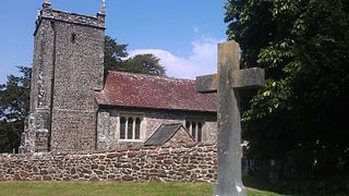
St Mary the Virgin is the Church of England parish church of Lytchett Matravers in Dorset. Its parish is part of the Diocese of Salisbury. The building is Grade I listed.
Lytchett may refer to the following places in England:

St Aldhelm's Church is a private church in Lytchett Heath, Dorset, England. It was designed by George Crickmay for Lord Eustace Cecil and built in 1898. It has been a Grade II* listed building since 1984. The lychgate of the churchyard is also Grade II listed.

