
Belo Horizonte is the sixth-largest city in Brazil, with a population around 2.7 million and with a metropolitan area of 6 million people. It is the 13th-largest city in South America and the 18th-largest in the Americas. The metropolis is anchor to the Belo Horizonte metropolitan area, ranked as the third-most populous metropolitan area in Brazil and the 17th-most populous in the Americas. Belo Horizonte is the capital of the state of Minas Gerais, Brazil's second-most populous state. It is the first planned modern city in Brazil.

Minas Gerais is a state in Southeastern Brazil. It ranks as the second most populous, the third by gross domestic product (GDP), and the fourth largest by area in the country. The state's capital and largest city, Belo Horizonte, is a major urban and finance center in Latin America, and the sixth largest municipality in Brazil, after the cities of São Paulo, Rio de Janeiro, Salvador, Brasília and Fortaleza, but its metropolitan area is the third largest in Brazil with just over 5,800,000 inhabitants, after those of São Paulo and Rio de Janeiro. Nine Brazilian presidents were born in Minas Gerais, the most of any state. The state has 10.1% of the Brazilian population and is responsible for 8.7% of the Brazilian GDP.

Juiz de Fora, also known as J.F., is a city in the southeastern Brazilian state of Minas Gerais, approximately 40 kilometres (25 mi) from the state border with Rio de Janeiro. According to 2020 estimates the current population is about 573,285 inhabitants. The geographical area of the municipality is 1,437 km2 (555 sq mi).

Diamantina is a Brazilian municipality in the state of Minas Gerais. Its estimated population in 2020 was 47,825 in a total area of 3,870 km2.
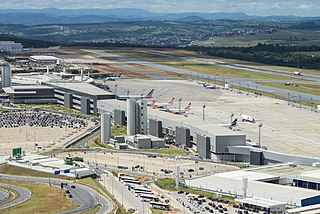
Belo Horizonte/Confins – Tancredo Neves International Airport, formerly called Confins International Airport is the primary international airport serving Belo Horizonte. Since 2 September 1986 the airport is named after Tancredo de Almeida Neves (1910–1985), President-elect of Brazil. It is located in the municipality of Confins, in the state of Minas Gerais. It is operated by BH Airport S.A.

Andrelândia is a Brazilian municipality in the state of Minas Gerais. It is in the Southeast and South Mesoregion of Minas and includes the Microregion of Andrelândia, located about 300 kilometres (190 mi) south of Belo Horizonte, the state capital.

Pampulha–Carlos Drummond de Andrade Airport is an airport serving Belo Horizonte, Brazil, located in the neighborhood of Pampulha. Since December 16, 2004 the airport is also named after the Minas Gerais-born poet Carlos Drummond de Andrade (1902–1987).

Ponte Nova is a municipality in central-eastern Minas Gerais state, Brazil.

Itabira is a Brazilian municipality and a major city in the state of Minas Gerais. The city belongs to the Belo Horizonte metropolitan area mesoregion and to the Itabira microregion.

Oliveira is a Brazilian municipality in the state of Minas Gerais. It is located at latitude 20º41'47" south and longitude 44º49'38" west, at an altitude of 982 metres. It is located 165 kilometres at southwest from Belo Horizonte. Its estimated population was 41,181 according to the latest IBGE census.

Confins is a Brazilian municipality located in the state of Minas Gerais. Its population as of 2020 is estimated to be 6,800 people. The area of the municipality is 42.008 km². The city belongs to the mesoregion Metropolitana de Belo Horizonte and to the microregion of Belo Horizonte. It is home of the international airport of Belo Horizonte, Tancredo Neves International Airport.

Rio Vermelho is a Brazilian municipality located in the state of Minas Gerais. The city belongs to the mesoregion Metropolitana de Belo Horizonte and to the microregion of Conceição do Mato Dentro. As of 2020, the estimated population was 12,739.
Santo Antônio do Rio Abaixo is a Brazilian municipality located in the state of Minas Gerais. The city belongs to the mesoregion of Belo Horizonte and to the microregion of Conceição do Mato Dentro. The estimated population in 2020 was 1,760 inhabitants.
Itamarandiba is a Brazilian municipality located in the north-center of the state of Minas Gerais. Its population as of 2020 was 34,936 living in a total area of 2,736 km².

Felício dos Santos is a Brazilian municipality located in the center-north of the state of Minas Gerais. Its population as of 2020 was 4,704 living in a total area of 358 km². The city belongs to the statistical mesoregion of Jequitinhonha and to the statistical microregion of Diamantina. It became a municipality in 1953.

Dionísio is a municipality in the state of Minas Gerais, Brazil. The city belongs to the mesoregion Metropolitana de Belo Horizonte and to the microregion of Itabira. As of 2020, the estimated population was 7,609.

BR-040 is a federal highway of Brazil. The 1,139.3 kilometres (707.9 mi) road connects Brasilia to Rio de Janeiro.

Greater Belo Horizonte, Brazil, is the name usually used to describe the Belo Horizonte metropolitan region, which is composed of 34 municipalities. As of 2013, it is the third largest metropolitan area of Brazil with more than Six million inhabitants; the largest city by population is Belo Horizonte.

The Immediate Geographic Region of Belo Horizonte is one of the 10 immediate geographic regions in the Intermediate Geographic Region of Belo Horizonte, one of the 70 immediate geographic regions in the Brazilian state of Minas Gerais and one of the 509 of Brazil, created by the National Institute of Geography and Statistics (IBGE) in 2017.

