MIKE 11 is a computer program that simulates flow and water level, water quality and sediment transport in rivers, flood plains, irrigation canals, reservoirs and other inland water bodies. MIKE 11 is a 1-dimensional river model. It was developed by DHI.
MIKE 11 has long been known as a software tool with advanced interface facilities.
Since the beginning MIKE 11 was operated through an efficient interactive menu system with systematic layouts and sequencing of menus. It is within that framework where the latest ‘Classic’ version of MIKE 11 – version 3.20 was developed.
The new generation of MIKE 11 combines the features and experiences from the mike11 MIKE 11 ‘Classic’ period, with the powerful Windows based user interface including graphical editing facilities and improved computational speed gained by the full utilization of 32-bit technology.
Modules
The computational core of MIKE 11 is a hydrodynamic simulation engine, and this is complemented by a wide range of additional modules and extensions covering almost all conceivable aspects of river modeling.
GIS Extension: an extension of ArcMap from ESRI providing features for catchment/river delineation, cross-section and Digital Elevation Model(DEM) data, pollution load estimates, flood visualisation/animation as 2D maps and results presentation/analysis using Temporal Analyst.
RR module: a rainfall runoff module, including the unit hydrograph method (UHM), a lumped conceptual continuous hydrological model and a monthly soil moisture accounting model. It includes an auto-calibration tool to estimate model parameter based on statistic data of comparison of simulated water levels/discharges and observations.
SO module: a structure operation module. It simulates operational structures such as sluice gates, weirs, culverts, pumps, bridges with operating strategies.
DB module: a dam break module. It provides complete facilities for definition of dam geometry, breach development in time and space as well as failure mode.
AUTOCAL module: an automatic calibration tool. It allows automisation of the calibration process for a wide range of parameters, including rainfall runoff parameters, Manning's number, head loss coefficients, water quality parameters etc.
AD module: an advection dispersion module. It simulates transport and spreading of conservative pollutants and constituents as well as heat with linear decay.
ST/GST module: a noncohesive sediment module. It simulates transport, erosion and deposition of non-cohesive and graded noncohesive sediments, including simulations of river morphology.
ACS module: a cohesive sediment module. It has 3-layer bed description, including quasi-2D erosion.
MIKE ECO Lab module: provides ecological modeling. It can simulate BOD/DO, Ammonia, Nitrate, Eutrophication, heavy metals and Wetlands. It includes standard templates that are well documented and have been used extensively in numerous applications worldwide. Based on predefined process templates, one can develop his/her own templates.
MIKE 11 Stratified module: models vertical density differences such as salinity or temperature in two-layer or multi-layered stratified water bodies.
MIKE 11 Real Time module: a simulation package and GIS front-end for setting up operational flood forecasting systems. It includes real-time updating and kalman filtering.
Applications
MIKE 11 has been used in hundreds of application around the world. Its main application areas are flood analysis and alleviation design, real-time flood forecasting, dam break analysis, optimisation of reservoir and canal gate/structure operations, ecological and water quality assessments in rivers and wetlands, sediment transport and river morphology studies, salinity intrusion in rivers and estuaries.
Hydraulic engineering as a sub-discipline of civil engineering is concerned with the flow and conveyance of fluids, principally water and sewage. One feature of these systems is the extensive use of gravity as the motive force to cause the movement of the fluids. This area of civil engineering is intimately related to the design of bridges, dams, channels, canals, and levees, and to both sanitary and environmental engineering.
The United States Environmental Protection Agency (EPA) Storm Water Management Model (SWMM) is a dynamic rainfall–runoff–subsurface runoff simulation model used for single-event to long-term (continuous) simulation of the surface/subsurface hydrology quantity and quality from primarily urban/suburban areas.
An hydrological transport model is a mathematical model used to simulate the flow of rivers, streams, groundwater movement or drainage front displacement, and calculate water quality parameters. These models generally came into use in the 1960s and 1970s when demand for numerical forecasting of water quality and drainage was driven by environmental legislation, and at a similar time widespread access to significant computer power became available. Much of the original model development took place in the United States and United Kingdom, but today these models are refined and used worldwide.
The HBV hydrology model, or Hydrologiska Byråns Vattenbalansavdelning model, is a computer simulation used to analyze river discharge and water pollution. Developed originally for use in Scandinavia, this hydrological transport model has also been applied in a large number of catchments on most continents.
HEC-RAS is simulation software used in computational fluid dynamics – specifically, to model the hydraulics of water flow through natural rivers and other channels.
Reservoir simulation is an area of reservoir engineering in which computer models are used to predict the flow of fluids through porous media.
Salal Dam, also known as Salal Hydroelectric Power Station, is a run-of-the-river hydropower project on the Chenab River in the Reasi district of the Jammu and Kashmir. It was the first hydropower project built by India in Jammu and Kashmir under the Indus Water Treaty regime. After having reached a bilateral agreement with Pakistan in 1978, with significant concessions made to Pakistan in the design of the dam, reducing its height, eliminating operating pool, and plugging the under-sluices meant for sediment management, India completed the project in 1987. The concessions made in the interest of bilateralism damaged the long-term sustainability of the dam, which silted up in five years. It currently runs at 57% capacity factor. Its long-term future is uncertain.
SMS is a complete program for building and simulating surface water models from Aquaveo. It features 1D and 2D modeling and a unique conceptual model approach. Currently supported models include ADCIRC, CMS-FLOW2D, FESWMS, TABS, TUFLOW, BOUSS-2D, CGWAVE, STWAVE, CMS-WAVE (WABED), GENESIS, PTM, and WAM.
MIKE FLOOD is a computer program that simulates inundation for rivers, flood plains and urban drainage systems. It dynamically couples 1D and 2D modeling techniques into one single tool. MIKE FLOOD is developed by DHI.
MOUSE, short for MOdel for Urban SEwers, is a computer program that models collection system for urban wastewater and stormwater. MOUSE is the first micro-computer based software created by DHI and it was developed in 1983. The MOUSE engine is used in the CS - Pipeflow module of the hydraulic modeling software MIKE URBAN.
MIKE 21 is a computer program that simulates flows, waves, sediments and ecology in rivers, lakes, estuaries, bays, coastal areas and seas in two dimensions. It was developed by DHI.
MIKE 21C is a computer program that simulates the development in the river bed and channel plan form in two dimensions. MIKE 21C was developed by DHI. MIKE 21C uses curvilinear finite difference grids.
GSSHA is a two-dimensional, physically based watershed model developed by the Engineer Research and Development Center of the United States Army Corps of Engineers. It simulates surface water and groundwater hydrology, erosion and sediment transport. The GSSHA model is used for hydraulic engineering and research, and is on the Federal Emergency Management Agency (FEMA) list of hydrologic models accepted for use in the national flood insurance program for flood hydrograph estimation. Input is best prepared by the Watershed Modeling System interface, which effectively links the model with geographic information systems (GIS).
ANUGA Hydro is a free and open source software tool for hydrodynamic modelling, suitable for predicting the consequences of hydrological disasters such as riverine flooding, storm surges and tsunamis. For example, ANUGA can be used to create predicted inundation maps based on hypothetical tsunami or flood scenarios. The ANUGA name without qualification is used informally to mean the ANUGA Hydro tool.
SHETRAN is a hydrological modelling system for water flow, solute and sediment transport in river catchments. SHETRAN is a physically based, distributed model (PBDM) that can simulate the entire land phase of the hydrologic cycle including surface water flow and groundwater flow. The plan area of the catchment in SHETRAN is usually in the range of one to a few thousand square kilometres and the horizontal depth of the subsurface is usually less than 100m.
In computational fluid dynamics, TELEMAC is short for the open TELEMAC-MASCARET system, or a suite of finite element computer program owned by the Laboratoire National d'Hydraulique et Environnement (LNHE), part of the R&D group of Électricité de France. After many years of commercial distribution, a Consortium was officially created in January 2010 to organize the open source distribution of the open TELEMAC-MASCARET system now available under GPLv3.
In hydrology, routing is a technique used to predict the changes in shape of a hydrograph as water moves through a river channel or a reservoir. In flood forecasting, hydrologists may want to know how a short burst of intense rain in an area upstream of a city will change as it reaches the city. Routing can be used to determine whether the pulse of rain reaches the city as a deluge or a trickle.
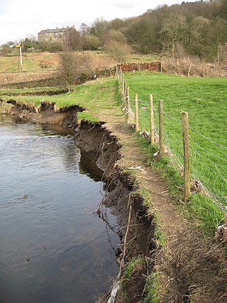
River bank failure can be caused when the gravitational forces acting on a bank exceed the forces which hold the sediment together. Failure depends on sediment type, layering, and moisture content.
The North Jiangsu Main Irrigation Canal is located in the lower reaches of the Huai River, one of the major rivers in the north of Jiangsu Province, China. It originates at Gaoliangjian on Hongze Lake and runs through Hongze, Qingpu, Huai'an, Funing, Sheyang and Binghai county(or district) and joins the artificial estuary of Biandan Harbour. The canal is 168 km in length and can irrigate 1,720,000 hectares of farmland. The construction program was organized and directed by the headquarters of the Jiangsu Huai River management program between October 1951 and May 1952.
DHI is an international water software development and engineering consultancy firm with headquarters in Denmark. The not-for-profit organisation addresses all challenges in water environments through consultancy services, MIKE Powered by DHI water modelling software, business applications, data portals and operational services. DHI has 30 offices throughout the world, with software development centres in Singapore and Denmark, and approximately 1050 employees.
This page is based on this Wikipedia article Text is available under the CC BY-SA 4.0 license; additional terms may apply. Images, videos and audio are available under their respective licenses.