Macellum Liviae ("market of Livia") was a shopping complex built by Augustus in the name of his wife Livia built on the Esquiline Hill in Rome.
Contents


Macellum Liviae ("market of Livia") was a shopping complex built by Augustus in the name of his wife Livia built on the Esquiline Hill in Rome.
Probably to be identified with τὸ τεμένισμα τὸ Λίουιον ὠνομασμένον (to temenisma to Liouion ōnomasmenon), which Tiberius dedicated at the beginning of 7 BC. [1] A restoration between 364 and 378 by Valentinian I, Valens and Gratian is recorded in an inscription, [2] and either this macellum or the Macellum Magnum is marked on fragment 4 of the Severan Marble Plan of Rome. [3]
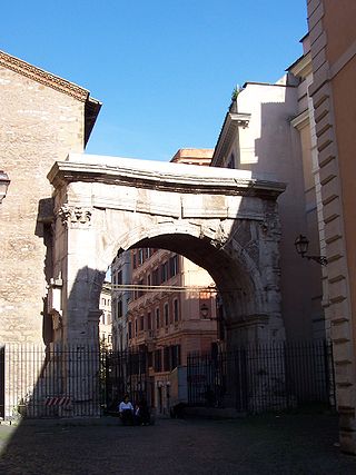
In the Chronicle of Benedict of Soracte under the year 921, [4] the aecclesia Sancti Eusebii iuxta macellum parvum (church of Sant'Eusebio next to the small market) is mentioned. [5] In the Liber Pontificalis the church of Santa Maria Maggiore was described as iuxta macellum Libiae (next to Libia's market), [6] and that of San Vito in Macello; [7] and the processional route described by the Lateran canon Benedict, the Ordo Benedicti of 1143, notes intrans sub arcum [8] ubi dicitur macellum Livianum ("ientering under the arch [of Gallienus] where it is called the Livian market"). [9]
Ruins corresponding with these literary indications have been found just outside the porta Esquilina, north of the road, which may well have been those of this macellum. They consist of an open court, 80 m × 25 m (262 ft × 82 ft), built of brick in opus reticulatum , and parallel with the line of the Servian Wall. This was surrounded with a porticus and shops for various kinds of wares. The southern part of this area seems to have been encroached upon by private dwellings as early as the third century. [10]

Pope Benedict XIV, born Prospero Lorenzo Lambertini, was head of the Catholic Church and ruler of the Papal States from 17 August 1740 to his death in May 1758.

Monte Cassino is a rocky hill about 130 kilometres (80 mi) southeast of Rome, in the Latin Valley, Italy, 2 kilometres west of Cassino and at an elevation of 520 m (1,710 ft). Site of the Roman town of Casinum, it is widely known for its abbey, the first house of the Benedictine Order, having been established by Benedict of Nursia himself around 529. It was for the community of Monte Cassino that the Rule of Saint Benedict was composed.
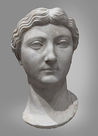
Livia Drusilla was Roman empress from 27 BC to 14 AD as the wife of Emperor Caesar Augustus. She was known as Julia Augusta after her formal adoption into the Julian family in AD 14.
Capua is a city and comune in the province of Caserta, in the region of Campania, southern Italy, situated 25 km (16 mi) north of Naples, on the northeastern edge of the Campanian plain.

The Palatine Hill, which relative to the seven hills of Rome is the centremost, is one of the most ancient parts of the city and has been called "the first nucleus of the Roman Empire." The site is now mainly a large open-air museum while the Palatine Museum houses many finds from the excavations here and from other ancient Italian sites.

The Forum Boarium was the cattle market or forum venalium of ancient Rome. It was located on a level piece of land near the Tiber between the Capitoline, the Palatine and Aventine hills. As the site of the original docks of Rome, the Forum Boarium experienced intense commercial activity.

The Servian Wall was an ancient Roman defensive barrier constructed around the city of Rome in the early 4th century BC. The wall was built of volcanic tuff and was up to 10 m (33 ft) in height in places, 3.6 m (12 ft) wide at its base, 11 km (6.8 mi) long, and is believed to have had 16 main gates, of which only one or two have survived, and enclosed a total area of 246 hectares. In the 3rd century AD it was superseded by the construction of the larger Aurelian Walls as the city of Rome grew beyond the boundary of the Servian Wall.

The Forum Piscarium was the fish market of ancient Rome, north of the Roman Forum, between the Sacra Via and the Argiletum. It was burned in 210 BC and rebuilt the next year. In 179 BC it was incorporated in the general Macellum, built by Marcus Fulvius Nobilior in the same region.

The Basilica Aemilia was a civil basilica in the Roman Forum, in Rome, Italy. Today only the plan and some rebuilt elements can be seen. The Basilica was 100 meters (328 ft) long and about 30 meters (98 ft) wide. Along the sides were two orders of 16 arches, and it was accessed through one of three entrances.
The Via Labicana was an ancient road of Italy, leading east-southeast from Rome. It seems possible that the road at first led to Tusculum, that it was then extended to Labici, and later still became a road for through traffic; it may even have superseded the Via Latina as a route to the southeast, for, while the distance from Rome to their main junction at Ad Bivium is practically identical, the summit level of the former is 22 metres (72 ft) lower than that of the latter, a little to the west of the pass of Mount Algidus. After their junction it is probable that the road bore the name Via Latina rather than Via Labicana. The course of the road after the first six miles from Rome is not identical with that of any modern road, but can be clearly traced by remains of pavement and buildings along its course.

Prima Porta is the 58th zona of Rome, identified by the initials Z. LVIII. The name Prima Porta came from an arch of the aqueduct that brought water to the Villa of Livia, which formed over Via Flaminia a sort of gateway which travellers saw as the first indication of having reached Rome (Piperno).

The Pons Cestius is an ancient Roman bridge connecting the right bank of the Tiber with the west of the Tiber Island in Rome, Italy. In Late Antiquity, the bridge was replaced and renamed the Pons Gratiani. It is also known as Ponte San Bartolomeo. No more than one third of the present stone bridge is of ancient material, as it was entirely rebuilt and extended in the 19th century, after numerous earlier restorations.

The Villa of Livia is an ancient Roman villa at Prima Porta, 12 kilometres (7.5 mi) north of Rome, Italy, along the Via Flaminia. It may have been part of Livia Drusilla's dowry that she brought when she married Octavian, her second husband, in 39 BC. However, it may also have been a gift given to her by Octavian upon their betrothal. The ancient sources tell us that Livia returned to this villa following the marriage. It was her sumptuous country residence complementing her house on the Palatine Hill in Rome.

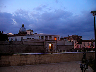
The Porta Esquilina was a gate in the Servian Wall, of which the Arch of Gallienus is extant today. Tradition dates it back to the 6th century BC, when the Servian Wall was said to have been built by the Roman king Servius Tullius. However modern scholarship and evidence from archaeology indicate a date in the fourth century BC. The archway of the gate was rededicated in 262 as the Arch of Gallienus.

The Lateran Obelisk is the largest standing ancient Egyptian obelisk in the world, and it is also the tallest obelisk in Italy. It originally weighed 413 tonnes, but after collapsing and being re-erected 4 metres (13 ft) shorter, now weighs around 300 tonnes. It is located in Rome, in the square across from the Archbasilica of St. John Lateran and the San Giovanni Addolorata Hospital.
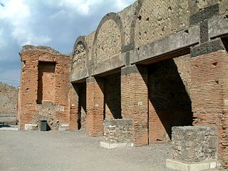
A macellum is an ancient Roman indoor market building that sold mostly provisions. The building normally sat alongside the forum and basilica, providing a place in which a market could be held. Each macellum sold different kinds of produce, depending on local availability, but it was not uncommon to import these comestibles, especially at ports like Pompeii.

Santi Vito e Modesto is a Roman Catholic church, and appears to have two facades, a 20th-century marble facade on Via Carlo Alberto, but a rustic brick older entrance, in reality the apse, on the Via San Vito in the Rione Esquilino of Rome, Italy. It has also been called Santi Vito, Modesto e Crescenzia. It is located, adjacent to the Servian Wall, near the former Monastery of the Viperesche.

The Church of San Lorenzo in Piscibus is a 12th-century small church in the Borgo rione of Rome. It is located near Saint Peter's Square and Vatican City, but its façade is not visible from the main street, Via della Conciliazione.
The Arch of Gratian, Valentinian and Theodosius was a triumphal arch built between 379 and 383 AD in Rome. It was situated at the south end of the Pons Aelius, near to the site later occupied by the church of San Celso. It formed as a monumental entrance arch to the bridge.

A tholos, from Ancient Greek θόλος, meaning "dome"), in Latin tholus, is an architectural feature that was widely used in the classical world. It is a round structure, usually built upon a couple of steps, with a ring of columns supporting a domed roof. It differs from a monopteros, a circular colonnade supporting a roof but without any walls, which therefore does not have a cella.