John Rae was a Scottish Orcadian surgeon who explored parts of northern Canada.

Great Slave Lake is the second-largest lake in the Northwest Territories of Canada, the deepest lake in North America at 614 metres, and the tenth-largest lake in the world. It is 469 km (291 mi) long and 20 to 203 km wide. It covers an area of 27,200 km2 (10,502 sq mi) in the southern part of the territory. Its given volume ranges from 1,070 km3 (260 cu mi) to 1,580 km3 (380 cu mi) and up to 2,088 km3 (501 cu mi) making it the 10th or 12th largest by volume.

Events from the year 1793 in Canada.

The Beaufort Sea is a marginal sea of the Arctic Ocean, located north of the Northwest Territories, the Yukon, and Alaska, and west of Canada's Arctic islands. The sea is named after Sir Francis Beaufort, a hydrographer. The Mackenzie River, the longest in Canada, empties into the Canadian part of the Beaufort Sea west of Tuktoyaktuk, which is one of the few permanent settlements on the sea's shores.

The Canadian Northern Railway (CNoR) was a historic Canadian transcontinental railway. At its 1923 merger into the Canadian National Railway, the CNoR owned a main line between Quebec City and Vancouver via Ottawa, Winnipeg, and Edmonton.

A bird observatory is a centre for the study of bird migration and bird populations. They are usually focused on local birds, but may also include interest in far-flung areas. Most bird observatories are small operations with a limited staff, many volunteers and a not-for-profit educational status. Many bird observatories conduct bird ringing or bird banding.
The vastness of Canada's Northwest Territories meant that for much of its history it was divided into several districts for ease of administration. The number and size of these territorial districts varied as other provinces and territories of Canada were created and expanded. The districts of the Northwest Territories were abolished in 1999 with the creation of Nunavut territory and the contraction of the Northwest Territories to its current size.

Mackenzie King Island is one of the Queen Elizabeth Islands in northern Canada. It lies north of Melville Island and south of Borden Island, and like them is divided. Most of the island is in Northwest Territories, while its easternmost portion lies in Nunavut. The border runs along the 110th meridian west.
Mackenzie, MacKenzie, or McKenzie may refer to:

The British Arctic territories, now known as the Arctic Archipelago were claimed by the United Kingdom in North America. The region was part of British North America.
The Artificial Reef Society of British Columbia (ARSBC) is a registered non-profit society based in Vancouver, British Columbia (BC), and is a registered tax-deductible charity in Canada.

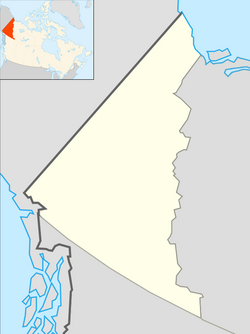
The Northwest Territories is a territory in Northern Canada, specifically in Northwestern Canada between Yukon Territory and Nunavut including part of Victoria Island, Melville Island, and other islands on the western Arctic Archipelago. Originally a much wider territory enclosing most of central and northern Canada, the Northwest Territories was created in 1870 from the Hudson's Bay Company's holdings that were sold to Canada from 1869-1870. In addition, Alberta and Saskatchewan were formed from the territory in 1905. In 1999, it was divided again: the eastern portion became the new territory of Nunavut. Yellowknife stands as its largest city and capital. It has a population of 42,800 and has an area of 532,643 sq mi (1,379,540 km2). The current territory lies west of Nunavut, north of latitude 60° north, and east of Yukon.

Foster Bay is a large bay of the Greenland Sea in King Christian X Land, Eastern Greenland. Administratively it belongs to the NE Greenland National Park area.

Djerassi Glacier is a 2.8 km long and 1 km wide steep valley glacier situated south of Gorichane Glacier, west of the head of Malpighi Glacier, northwest of the head of Mackenzie Glacier, and north-northeast of Pirogov Glacier on Brabant Island in the Palmer Archipelago, Antarctica. It drains the west slopes of Harvey Heights and the north slopes of Mount Parry, and flows northwestwards into Lanusse Bay north of Venchan Peak.
Pirogov Glacier is a 5 km long and 1.5 km wide glacier situated south of Djerassi Glacier, west of the head of Mackenzie Glacier and northwest of Balanstra Glacier on Brabant Island in the Palmer Archipelago, Antarctica. It drains the south-southwest slopes of Mount Parry and flows westwards to enter Dallmann Bay south of Minot Point.
The Rae–Richardson Polar Expedition of 1848 was an early British effort to determine the fate of the lost Franklin Polar Expedition. Led overland by Sir John Richardson and John Rae, the team explored the accessible areas along Franklin's proposed route near the Mackenzie and Coppermine rivers.
Kendall Island is one of the irregularly shaped, uninhabited Canadian arctic islands in the Northwest Territories, Canada. It is located in Mackenzie Bay at the northern tip of the Mackenzie River Delta. Richards Island is to the southwest of Kendall Island. Kugmallit Bay is bounded by Garry, Pelly Island and Kendall Islands. The northeast portion of the island is high.

Cape Robertson is a cape which marks the west side of the entrance to Jessie Bay, in the north-west part of Laurie Island, in the South Orkney Islands of Antarctica.
The Waihemo by-election was a by-election in the New Zealand electorate of Waihemo, a rural seat in Otago, in the South Island.