This article has multiple issues. Please help improve it or discuss these issues on the talk page . (Learn how and when to remove these messages)
|
Madhugiri | |
|---|---|
city | |
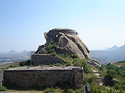 Madhugiri Fort | |
 Madhugiri Location in Karnataka, India | |
| Coordinates: 13°40′N77°13′E / 13.66°N 77.21°E | |
| Country | |
| State | Karnataka |
| District | Tumakuru [1] |
| Government | |
| • Type | municipal council |
| Elevation | 787 m (2,582 ft) |
| Population (2001) | |
• Total | 29,215 |
| Languages | |
| • Official | Kannada |
| Time zone | UTC+5:30 (IST) |
| PIN | |
| Vehicle registration | KA-64 |
Madhugiri is a city in Tumkur district in the Indian state of Karnataka. The city derives its name from a hillock, Madhu-giri (honey-hill) which lies to its south. Madhugiri is one of the 34 educational districts of the Karnataka state. [2]