Magic Island (Hawaii)

Last updated
Magic Island
Honolulu04.JPG
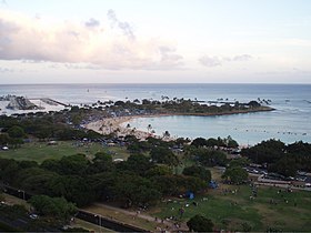
Aerial view of Magic Island, featuring Ala Wai Yacht Harbor
Magic Island (Hawaii)
Location Honolulu, Hawaii
Coordinates 21°17′05″N157°50′48″W / 21.284596°N 157.846595°W / 21.284596; -157.846595 Coordinates: 21°17′05″N157°50′48″W / 21.284596°N 157.846595°W / 21.284596; -157.846595

Magic Island is a small man-made peninsula in Honolulu, Hawaii, adjacent to Ala Moana Beach Park and the Ala Wai Yacht Harbor. [1] It was created in 1964 as the site of a resort complex, but was subsequently converted to a park. [2] The name was changed to "Aina Moana," but the new name is used infrequently. [3]

The park on Magic Island is a popular spot where people gather for picnics, frisbee, socializing, and occasional festival or drama performances. Because it was a preferred location among homeless squatters, overnight camping was recently banned in the park.

Each year, the Ala Moana Center puts on a fireworks show over Magic Island for the Fourth of July that draws numerous spectators to the surrounding parks. In conjunction with the show, the Ala Moana Center ropes off a portion of its parking lot for a Fourth of July concert featuring many local bands.

The park's hours are from sunrise to sunset daily.

Magic Island during the day Magic Island.jpg
Magic Island during the day
Fireworks over Magic Island Fireworks Magic Island.jpg
Fireworks over Magic Island

Related Research Articles

Honolulu State capital city in Hawaii, United States

Honolulu is the capital and largest city of the U.S. state of Hawaii, which is located in the Pacific Ocean. It is an unincorporated county seat of the consolidated City and County of Honolulu, situated along the southeast coast of the island of Oʻahu, and is the westernmost and southernmost major U.S. city. Honolulu is Hawaii's main gateway to the world. It is also a major hub for international business, finance, hospitality, and military defense in both the state and Oceania. The city is characterized by an eclectic mix of various Asian, Western, and Pacific cultures, as reflected in its diverse demography, cuisine, and traditions.

Oahu Third-largest of the Hawaiian Islands and site of the state capital Honolulu

Oahu, also known as "The Gathering Place", is the third-largest of the Hawaiian Islands. It is home to roughly one million people—about two-thirds of the population of the U.S. state of Hawaii. The island lies within Honolulu County and the state capital, Honolulu, is on Oahu's southeast coast.

Waikiki Neighborhood of Honolulu in Hawaii, United States

Waikiki is a neighborhood of Honolulu on the south shore of the island of Oʻahu in the U.S. state of Hawaii.

Kailua, Hawaii Census-designated place in Hawaii, United States

Kailua is a census-designated place (CDP) in Honolulu County, Hawaii, United States. It lies in the Koʻolaupoko District of the island of Oʻahu on the windward coast at Kailua Bay. It is in the judicial district and the ahupua'a named Ko'olaupoko. It is 12 miles (19 km) northeast of Honolulu – over Nu‘uanu Pali. The population was 38,635 at the 2010 census.

Mākaha, Hawaii Census-designated place in Hawaii, United States

Mākaha is a census-designated place (CDP) in Honolulu County, Hawaiʻi, United States. It is a town located along the Pacific coast, west of the Mākaha Valley, and at the foot of Mt. Ka'ala in the Wai’anae Mountain Range. It is the last of the leeward towns on O'ahu. North of Mākaha is little development, i.e. no towns, no gas stations, or restaurants. The population of Mākaha was 8,278 at the 2010 census. It is located 35 miles northwest of Honolulu, but is a part of Honolulu County.

Diamond Head, Hawaii Mountain on Oahu in Hawaii, United States of America

Diamond Head is a volcanic tuff cone on the Hawaiian island of Oʻahu and known to Hawaiians as Lēʻahi. The Hawaiian name is most likely derived from lae plus ʻahi (tuna) because the shape of the ridgeline resembles the shape of a tuna's dorsal fin. Its English name was given by British sailors in the 19th century, who mistook calcite crystals on the adjacent beach for diamonds.

Ala Moana Center Architectural structure and shopping mall in Honolulu, Hawaii

The Ala Moana Center, commonly known simply as Ala Moana, is a large open-air shopping mall in the Ala Moana neighborhood of Honolulu, Hawaii. Owned by Brookfield Retail Group, Ala Moana is the ninth largest shopping mall in the United States and the largest open-air shopping center in the world.

Ala Moana Beach Park

Ala Moana Beach Park is a free public park on the island of Oahu, U.S. state of Hawaii, located between Waikiki and downtown Honolulu. This 100-acre (0.40 km2) park has a wide gold-sand beach that is over a half-mile long.

King Kamehameha I Day

King Kamehameha I Day on June 11 is a public holiday in the U.S. state of Hawaii. It honors Kamehameha the Great, the monarch who first established the unified Kingdom of Hawaiʻi—comprising the Hawaiian Islands of Niʻihau, Kauaʻi, Oʻahu, Molokaʻi, Lānaʻi, Kahoʻolawe, Maui, and Hawaiʻi. In 1883 a statue of King Kamehameha was dedicated in Honolulu by King David Kalākaua. There are duplicates of this statue in Emancipation Hall at the Capitol Visitor Center in Washington, D.C. and in Hilo, island of Hawaiʻi.

Manoa Valley and a residential neighborhood of Honolulu, Hawaiʻi, United States

Mānoa is a valley and a residential neighborhood of Honolulu, Hawaiʻi. The neighborhood is approximately three miles east and inland from downtown Honolulu and less than a mile from Ala Moana and Waikiki at 21°18.87916′N157°48.4846′W.

Ala Moana, Honolulu

Ala Moana is a commercial, retail, and residential district of Honolulu, Hawaii. It is nestled between Waikiki and Moiliili to the east, and Kakaʻako and Honolulu Harbor to the west. King Street, to the north, marks the border with the neighborhood of Makiki.

Kewalo Basin

Kewalo Basin is a commercial boat harbor that serves as home to some of Honolulu's commercial fishing fleet, and charter and excursion vessels that serve the Hawaii tourist market. Pre-European contact, the area was historically used for human sacrifice. The land was given to Ihu by Kamehameha I and inherited by his daughter Kamakeʻe and her husband Jonah Piikoi. On the ocean side of the harbor is a small beach park on the Honolulu waterfront, located adjacent to the larger Ala Moana Beach Park. This park is good for swimming, picnicking and sightseeing. It can be accessed from the corners of Ala Moana Boulevard and Ward Avenue.

Hawaii Department of Public Safety

The Hawaii Department of Public Safety is a department within the executive branch of the government of the U.S. state of Hawaii. It is headquartered in the 919 Ala Moana Boulevard building in Honolulu, Hawaii. The department's mission statement is "To uphold justice and public safety by providing correctional and law enforcement services to Hawaii’s communities with professionalism, integrity and fairness.". The Department of Public Safety is made up of three divisions: Administration, Corrections, and Law Enforcement.

Hawaii Route 92

Route 92 is a major east–west highway on the island of Oahu which begins at exit 15 off Interstate H-1 (H-1) in Honolulu and ends 0.6 miles (0.97 km) east of the Ala Wai Canal crossing in Waikiki. The western portion, west of Richards Street, is locally known as the Nimitz Highway. East of Richards Street, Route 92 is locally known as Ala Moana Boulevard.

Honolulu County, Hawaii County in Hawaii, US

Honolulu County is a consolidated city–county in the U.S. state of Hawaii. The city–county includes both the city of Honolulu and the rest of the island of Oʻahu, as well as several minor outlying islands, including all of the Northwestern Hawaiian Islands except Midway Atoll.

The Ala Moana Hotel is a hotel in Honolulu, Hawaii, opened in 1970. It adjoins the Ala Moana Shopping Center and is across the street from the Hawaii Convention Center as well as the Ala Moana Beach Park.

Duke Paoa Kahanamoku Lagoon Man-made wading pool in Waikiki, Honolulu, United States

Duke Paoa Kahanamoku Lagoon is a small, man-made wading pool in the Waikiki neighborhood of Honolulu, on the south shore of the island of Oʻahu near the Ala Wai Small Boat Harbor and Fort DeRussy Military Reservation. The Hilton Hawaiian Village is adjacent to the lagoon.

Hoʻolulu

Hoʻolulu (1794–1844) was a member of the nobility during the formation of the Kingdom of Hawaii. He was a trusted advisor to King Kamehameha I, also known as "Kamehameha the Great", and was one of the select few to know his secret resting place. His descendants continue the tradition of guarding royal burials. A major cultural site in Hilo, Hawaii is named after him.

The Sullivan Family of Companies is a privately run American supermarket, retailer and restaurant franchiser headquartered in Honolulu, Hawaii. The family-owned business is run by Jenai S. Wall, the daughter of Maurice J. "Sully" Sullivan, who founded the Foodland supermarket chain, which she expanded after his death. Although all of the properties are under the same roof, each is run separately.

Saints Constantine and Helen Greek Orthodox Cathedral of the Pacific (Honolulu) Church in Hawaii, United States

Saints Constantine and Helen Greek Orthodox Cathedral of the Pacific is a Greek Orthodox cathedral in Honolulu, Hawaii.

References

  1. "Magic Island Lagoon | Hawaii Beach Safety". hawaiibeachsafety.com. Retrieved 2018-11-13.
  2. Kido, H. (2014). HISTORIC AMERICAN LANDSCAPES SURVEY : ALA MOANA PARK. http://lcweb2.loc.gov/master/pnp/habshaer/hi/hi1000/hi1008/data/hi1008data.pdf: National Park Service. pp. 6–7.CS1 maint: location (link)
  3. 1895-1986., Pukui, Mary Kawena (1974). Place names of Hawaii . Elbert, Samuel H. (Samuel Hoyt), 1907-1997,, Mookini, Esther T. (Rev. and enl. ed.). Honolulu: University Press of Hawaii. ISBN   082480208X. OCLC   1042464.CS1 maint: numeric names: authors list (link)